93.95.214.171 - IP Lookup: Free IP Address Lookup, Postal Code Lookup, IP Location Lookup, IP ASN, Public IP
Country:
 Netherlands
Region:
City:
Location:
Time Zone:
Postal Code:
ISP:
ASN:
language:
User-Agent:
Proxy IP:
Blacklist:
IP information under different IP Channel
ip-api
Country
Region
City
ASN
Time Zone
ISP
Blacklist
Proxy
Latitude
Longitude
Postal
Route
db-ip
Country
Region
City
ASN
Time Zone
ISP
Blacklist
Proxy
Latitude
Longitude
Postal
Route
IPinfo
Country
Region
City
ASN
Time Zone
ISP
Blacklist
Proxy
Latitude
Longitude
Postal
Route
IP2Location
93.95.214.171Country
nlRegion
fryslan
City
dokkum
Time Zone
Europe/Amsterdam
ISP
Language
User-Agent
Latitude
Longitude
Postal
ipdata
Country
Region
City
ASN
Time Zone
ISP
Blacklist
Proxy
Latitude
Longitude
Postal
Route
Popular places and events near this IP address
Dongeradeel
Municipality in Friesland, Netherlands
Distance: Approx. 1255 meters
Latitude and longitude: 53.33333333,6
Dongeradeel (Dutch: [ˈdɔŋəraːˌdeːl] ; West Frisian: Dongeradiel [ˈdoŋəraˌdiəl] ) is a former municipality in the northern Netherlands. In 2019 it merged with the municipalities of Ferwerderadiel and Kollumerland en Nieuwkruisland to form the new municipality Noardeast-Fryslân.
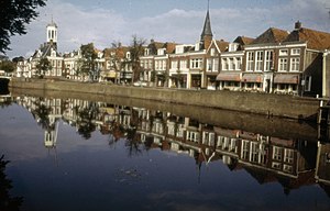
Dokkum
City in Friesland, Netherlands
Distance: Approx. 533 meters
Latitude and longitude: 53.32694444,5.99805556
Dokkum is a Dutch fortified city in the municipality of Noardeast-Fryslân in the province of Friesland. It has 12,669 inhabitants (February 8, 2020). The fortifications of Dokkum are well preserved and are known as the bolwerken (bulwarks).

Aalsum, Friesland
Village in Friesland, Netherlands
Distance: Approx. 1863 meters
Latitude and longitude: 53.33833333,6.00444444
Aalsum (West Frisian: Ealsum) is a village in the Dutch province of Friesland. It is located in the municipality Noardeast-Fryslân, about 1 km north of Dokkum. It had a population of around 125 in January 2017 Aalsum is built on a partially excavated terp, around a church originally dedicated to St.

Wâlterswâld
Village in Friesland, Netherlands
Distance: Approx. 3456 meters
Latitude and longitude: 53.3,6.03333333
Wâlterswâld (Dutch: Wouterswoude) is a village in Dantumadiel municipality, Friesland, the Netherlands. The village had a population of approximately 920 in 2017. The village as two residential centers, a northern and southern center.

Boarnwert
Village in Friesland, Netherlands
Distance: Approx. 3186 meters
Latitude and longitude: 53.33361111,5.95305556
Boarnwert (Dutch: Bornwird) is a small village in Noardeast-Fryslân in the province of Friesland, the Netherlands. It had a population of around 119 in January 2017. Before 2019, the village was part of the Dongeradeel municipality.

Hiaure
Village in Friesland, Netherlands
Distance: Approx. 3227 meters
Latitude and longitude: 53.34722222,5.9725
Hiaure (West Frisian: De Lytse Jouwer) is a small village in Noardeast-Fryslân in the province of Friesland, the Netherlands. It had a population of around 65 in January 2017. Before 2019, the village was part of the Dongeradeel municipality.

Raard
Village in Friesland, Netherlands
Distance: Approx. 3430 meters
Latitude and longitude: 53.32611111,5.94583333
Raard is a village in Noardeast-Fryslân in the province of Friesland, the Netherlands. It had a population of around 223 in January 2017. Before 2019, the village was part of the Dongeradeel municipality.

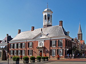
De Hoop, Dokkum
Smock mill in Friesland, Netherlands
Distance: Approx. 95 meters
Latitude and longitude: 53.32277778,5.99805556
De Hoop (English: The Hope) is a smock mill in Dokkum, Friesland, Netherlands which was built in 1849 and has been restored to working order. The mill is listed as a Rijksmonument, number 13186.

Zeldenrust, Dokkum
Distance: Approx. 302 meters
Latitude and longitude: 53.32444444,5.99444444
Zeldenrust is a smock mill in Dokkum, Friesland, Netherlands which was built in 1862 and has been restored to working order. The mill is listed as a Rijksmonument, number 13097.

De Mearmin
Smock mill in Friesland, Netherlands
Distance: Approx. 3299 meters
Latitude and longitude: 53.29388889,6.01166667
De Mearmin, formerly also known as Geestermermeermolen, is a smock mill in Damwâld, Friesland, Netherlands, which was built in 1968 at Dokkum. The mill is listed as a Rijksmonument, number 467708. Between 2014 and 2016, the mill was dismantled, restored and moved to a new site in Damwâld.

Protestant church of Damwâld-Moarrewâld
Church
Distance: Approx. 3523 meters
Latitude and longitude: 53.29055556,5.99694444
The Protestant church of Damwâld-Moarrewâld or Saint Boniface’s church is a religious building in Damwâld, one of the medieval churches in Friesland. It is a Romanesque church built c. 1200 out of red brick with a straight closed choir dating from the early 16th century and a tower from the 13th century.

Betterwird
Hamlet in Friesland, Netherlands
Distance: Approx. 2117 meters
Latitude and longitude: 53.33146,5.96919
Betterwird or Betterwurd is a hamlet in the municipality of Noardeast-Fryslân in Friesland, the Netherlands. Before 2019, the village was part of the Dongeradeel municipality. Betterwird is not a statistical entity, and the postal authorities have placed it under Bornwird.
Weather in this IP's area
haze
2 Celsius
-2 Celsius
2 Celsius
3 Celsius
1024 hPa
80 %
1024 hPa
1024 hPa
9000 meters
6.17 m/s
100 degree
75 %