Country:
 Great Britain
Region:
City:
Latitude and Longitude:
Time Zone:
Postal Code:
IP information under different IP Channel
ip-api
Country
Region
City
ASN
Time Zone
ISP
Blacklist
Proxy
Latitude
Longitude
Postal
Route
IPinfo
Country
Region
City
ASN
Time Zone
ISP
Blacklist
Proxy
Latitude
Longitude
Postal
Route
MaxMind
Country
Region
City
ASN
Time Zone
ISP
Blacklist
Proxy
Latitude
Longitude
Postal
Route
Luminati
Country
GBASN
Time Zone
Europe/London
ISP
Voiceflex Ltd
Latitude
Longitude
Postal
db-ip
Country
Region
City
ASN
Time Zone
ISP
Blacklist
Proxy
Latitude
Longitude
Postal
Route
ipdata
Country
Region
City
ASN
Time Zone
ISP
Blacklist
Proxy
Latitude
Longitude
Postal
Route
Popular places and events near this IP address

Regent Street
Shopping street in London
Distance: Approx. 60 meters
Latitude and longitude: 51.5108,-0.1387
Regent Street is a major shopping street in the West End of London. It is named after George, the Prince Regent (later George IV) and was laid out under the direction of the architect John Nash and James Burton. It runs from Waterloo Place in St James's at the southern end, through Piccadilly Circus and Oxford Circus, to All Souls Church.
List of cathedrals in England
Distance: Approx. 26 meters
Latitude and longitude: 51.51123,-0.13792
This is a list of cathedrals in England, the Isle of Man, Guernsey and Jersey, as well as Gibraltar. Former and intended cathedrals are listed separately. A cathedral church is a Christian place of worship that is the chief, or "mother" church of a diocese and is distinguished as such by being the location for the cathedra or bishop's seat.

Golden Square
Square in Soho, London
Distance: Approx. 88 meters
Latitude and longitude: 51.51166667,-0.13722222
Golden Square, in Soho, the City of Westminster, London, is a mainly hardscaped garden square planted with a few mature trees and raised borders in Central London flanked by classical office buildings. Its four approach ways are north and south but it is centred 125 metres east of Regent Street and double that NNE of Piccadilly Circus. A small block south is retail/leisure street Brewer Street.
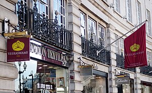
Veeraswamy
Indian restaurant in London
Distance: Approx. 112 meters
Latitude and longitude: 51.51,-0.13805556
Veeraswamy is an Indian restaurant in London, located at 99-101 Regent Street. It was opened in 1926 by Edward Palmer, an Anglo-Indian retired British Indian Army officer, the grandson of an English general and an Indian princess. It is the oldest surviving Indian restaurant in the United Kingdom.

New Gallery (London)
Building in London, England, originally an art gallery, then cinema, church, store
Distance: Approx. 88 meters
Latitude and longitude: 51.5106,-0.139
The New Gallery is a Crown Estate-owned Grade II Listed building at 121 Regent Street, London, which originally was an art gallery from 1888 to 1910, The New Gallery Restaurant from 1910 to 1913, The New Gallery Cinema from 1913 to 1953, and a Seventh-day Adventist Church from 1953 to 1992. After having been empty for more than ten years, the building was a Habitat furniture store from 2006 to 2011, and since September 2012 it is a flagship store for Burberry.

The Cat's Whisker
Coffee bar in Kingly Street, Soho, London
Distance: Approx. 130 meters
Latitude and longitude: 51.51208333,-0.13861111
The Cat's Whisker was a coffee bar situated at 1 Kingly Street, Soho, London, during the mid-late 1950s. It offered London youngsters Spanish dancing, live rock 'n roll, and skiffle. It saw the invention of a new style of 'dancing' known as hand-jive, dancing using hand gestures only as there was no space to maneuver in the crowded basement.
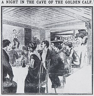
The Cave of the Golden Calf
Night club in London, England
Distance: Approx. 116 meters
Latitude and longitude: 51.5107,-0.1395
The Cave of the Golden Calf was a night club in London. In existence for only two years immediately before the First World War, it epitomised decadence, and still inspires cultural events. Its name is a reference to the Golden Calf of the Biblical story, a symbol of impermissible worship.
Titanic (restaurant)
Restaurant in London, England
Distance: Approx. 125 meters
Latitude and longitude: 51.51083333,-0.13611111
Titanic was a restaurant near Piccadilly Circus within the Regent Palace Hotel in London that was open between December 1998 and January 2002. It was operated by chef Marco Pierre White as a joint venture with the Forte Group. It became a known celebrity hang-out, but went through two legal battles; first with shipbuilders Harland and Wolff and then with Oliver Peyton, proprietor of the Atlantic Bar and Grill which was also within the same hotel.

Vigo Street
Distance: Approx. 109 meters
Latitude and longitude: 51.5103,-0.139
Vigo Street (originally Vigo Lane) is a short street in central London that is named after the Anglo-Dutch naval victory over the French and Spanish in the 1702 Battle of Vigo Bay. It has important literary connections.

Church of Our Lady of the Assumption and St Gregory
Catholic parish church in London
Distance: Approx. 26 meters
Latitude and longitude: 51.51123,-0.13792
The Church of Our Lady of the Assumption and St Gregory is a Catholic church on Warwick Street, Westminster. It is the oldest Catholic church in England (excluding those used as Anglican churches and then returned to Catholic usage). It was formerly known as the Royal Bavarian Chapel, because like several Catholic churches in London it originated as a chapel within a foreign embassy.
Stork Club, London
Nightclub in London, England
Distance: Approx. 121 meters
Latitude and longitude: 51.50991944,-0.13779167
The Stork Club was a nightclub in Swallow Street in London's West End. In the late 1950s, it was run by "nightclub king" Al Burnett, and notable guests included Harold Macmillan, John Profumo, Peter Sellers, Frank Sinatra, Lana Turner, Bette Davis, Ava Gardner, Elizabeth Taylor, King Hussein of Jordan, and Jean Simmons. The resident band for seven years was the Denny Termer trio, with Bill Bramwell on bass and Monty Babson on drums It was later owned by Oscar Owide, eventually becoming a brothel, before closing its doors in 2001.
Murray's Cabaret Club
London cabaret club 1913 - 1975
Distance: Approx. 124 meters
Latitude and longitude: 51.5121,-0.1382
Murray's Cabaret Club was a cabaret club in Beak Street in Soho, central London, England.
Weather in this IP's area
broken clouds
15 Celsius
15 Celsius
14 Celsius
15 Celsius
995 hPa
92 %
995 hPa
991 hPa
10000 meters
3.09 m/s
220 degree
75 %
07:09:46
18:27:08