Country:
Region:
City:
Latitude and Longitude:
Time Zone:
Postal Code:
IP information under different IP Channel
ip-api
Country
Region
City
ASN
Time Zone
ISP
Blacklist
Proxy
Latitude
Longitude
Postal
Route
Luminati
Country
Region
zh
City
zweidlendorf
ASN
Time Zone
Europe/Zurich
ISP
Monzoon Networks AG
Latitude
Longitude
Postal
IPinfo
Country
Region
City
ASN
Time Zone
ISP
Blacklist
Proxy
Latitude
Longitude
Postal
Route
db-ip
Country
Region
City
ASN
Time Zone
ISP
Blacklist
Proxy
Latitude
Longitude
Postal
Route
ipdata
Country
Region
City
ASN
Time Zone
ISP
Blacklist
Proxy
Latitude
Longitude
Postal
Route
Popular places and events near this IP address

Weiach
Municipality in Zurich, Switzerland
Distance: Approx. 2867 meters
Latitude and longitude: 47.55,8.43333333
Weiach is a municipality in the district of Dielsdorf in the canton of Zürich in Switzerland.
Stadel bei Niederglatt
Municipality in Zurich, Switzerland
Distance: Approx. 2820 meters
Latitude and longitude: 47.53333333,8.46666667
Stadel is a municipality in the district of Dielsdorf in the canton of Zürich in Switzerland.

Kaiserstuhl, Aargau
Former municipality in Aargau, Switzerland
Distance: Approx. 4054 meters
Latitude and longitude: 47.56666667,8.41666667
Kaiserstuhl is a village and former municipality in the district of Zurzach in the canton of Aargau in Switzerland. The small town is listed as a heritage site of national significance. On 1 January 2022 the former municipalities of Bad Zurzach, Baldingen, Böbikon, Kaiserstuhl, Rekingen, Rietheim, Rümikon and Wislikofen merged into the new municipality of Zurzach.

Glattfelden
Municipality in Zurich, Switzerland
Distance: Approx. 2475 meters
Latitude and longitude: 47.56666667,8.5
Glattfelden is a municipality in the district of Bülach in the canton of Zürich in Switzerland, and belongs to the Glatt Valley (German: Glattal).
Wasterkingen
Municipality in Zurich, Switzerland
Distance: Approx. 2760 meters
Latitude and longitude: 47.58333333,8.46666667
Wasterkingen is a municipality in the district of Bülach in the canton of Zürich in Switzerland.
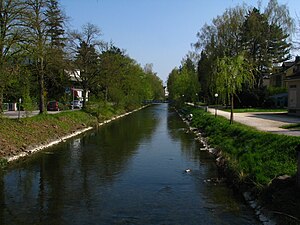
Glatt (Rhine)
River in Switzerland
Distance: Approx. 1719 meters
Latitude and longitude: 47.574,8.4709
Glatt (German pronunciation: [ˈɡlat]) is the name of a lesser affluent to the High Rhine in the Unterland of the canton of Zurich, Switzerland. It is 35.7 kilometres (22.2 mi) long and flows out from the Greifensee through the Glatt Valley, discharging into the Rhine by Glattfelden. Whereas the upper reaches are only gently inclined, the stream gets steeper beneath, forming banks of bed load.
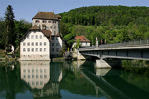
Hohentengen am Hochrhein
Municipality in Baden-Württemberg, Germany
Distance: Approx. 2947 meters
Latitude and longitude: 47.57,8.43388889
Hohentengen is a municipality in the district of Waldshut in Baden-Württemberg in Germany.
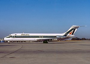
Alitalia Flight 404
1990 aviation accident
Distance: Approx. 2070 meters
Latitude and longitude: 47.54722222,8.4475
Alitalia Flight 404 (AZ404/AZA404) was an international passenger flight scheduled to fly from Linate Airport in Milan, Italy, to Zürich Airport in Zürich, Switzerland, which crashed on 14 November 1990. The McDonnell Douglas DC-9-32, operated by Alitalia, crashed into the woodlands of Weiach as it approached Zurich Airport, killing all 46 occupants on board. A Swiss investigation concluded that the accident was caused by a short circuit, which led to the failure of the aircraft's NAV receiver.
Zweidlen railway station
Railway station in Switzerland
Distance: Approx. 1317 meters
Latitude and longitude: 47.57038889,8.46788889
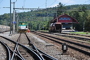
Zweidlen railway station (German: Bahnhof Zweidlen) is a railway station in the Swiss canton of Zürich and municipality of Glattfelden. It is located on the Winterthur to Koblenz line, and is served by Zürich S-Bahn line S36.
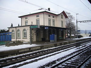
Eglisau railway station
Railway station in the canton of Zürich, Switzerland
Distance: Approx. 3871 meters
Latitude and longitude: 47.57238889,8.51661111
Eglisau railway station (German: Bahnhof Eglisau) is a railway station in the Swiss canton of Zurich and municipality of Eglisau. The station is located on the Winterthur to Koblenz line, at that line's junction with the Eglisau to Neuhausen line. Both lines are owned by Swiss Federal Railways.

Eglisau railway bridge
Distance: Approx. 3700 meters
Latitude and longitude: 47.57738,8.509941
The Eglisau railway bridge, or Eisenbahnbrücke Eglisau, is a single-track railway bridge which carries the Eglisau to Neuhausen line across the Rhine in Switzerland. Both ends of the bridge lie within the municipality of Eglisau and the canton of Zurich.
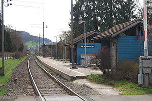
Kaiserstuhl AG railway station
Railway station in Switzerland
Distance: Approx. 3862 meters
Latitude and longitude: 47.56638889,8.41919444
Kaiserstuhl AG railway station (German: Bahnhof Kaiserstuhl AG) is a railway station in the Swiss canton of Aargau and municipality of Kaiserstuhl. The station is located on the Winterthur to Koblenz line of Swiss Federal Railways and is served by Zurich S-Bahn line S36. The ZVV busline 515 connects Kaiserstuhl with Bülach as well.
Weather in this IP's area
broken clouds
9 Celsius
7 Celsius
8 Celsius
10 Celsius
1027 hPa
91 %
1027 hPa
975 hPa
10000 meters
3.58 m/s
4.92 m/s
42 degree
75 %
07:13:24
17:05:54
