93.92.0.51 - IP Lookup: Free IP Address Lookup, Postal Code Lookup, IP Location Lookup, IP ASN, Public IP
Country:
Region:
City:
Location:
Time Zone:
Postal Code:
ISP:
ASN:
language:
User-Agent:
Proxy IP:
Blacklist:
IP information under different IP Channel
ip-api
Country
Region
City
ASN
Time Zone
ISP
Blacklist
Proxy
Latitude
Longitude
Postal
Route
db-ip
Country
Region
City
ASN
Time Zone
ISP
Blacklist
Proxy
Latitude
Longitude
Postal
Route
IPinfo
Country
Region
City
ASN
Time Zone
ISP
Blacklist
Proxy
Latitude
Longitude
Postal
Route
IP2Location
93.92.0.51Country
Region
norrbottens lan
City
kalix
Time Zone
Europe/Stockholm
ISP
Language
User-Agent
Latitude
Longitude
Postal
ipdata
Country
Region
City
ASN
Time Zone
ISP
Blacklist
Proxy
Latitude
Longitude
Postal
Route
Popular places and events near this IP address

Kalix Municipality
Municipality in Norrbotten County, Sweden
Distance: Approx. 571 meters
Latitude and longitude: 65.85,23.16666667
Kalix Municipality (Swedish: Kalix kommun, Finnish: Kainuun kunta) is a municipality in Norrbotten County in northern Sweden. Its seat is located in Kalix. In 1924 Töre Municipality was detached from Nederkalix Municipality, forming a municipality of its own.

Kalix
Municipality in Norrbotten County, Sweden
Distance: Approx. 571 meters
Latitude and longitude: 65.85,23.16666667
Kalix (Swedish: Kalix; Kalix dialect: Kôlis, pronounced [ˈcʰ(j)ɞɽɪs], phonemically /kɞɽis/; Finnish: Kainuu; Meänkieli: Kainus) is a locality and the seat of the Kalix Municipality in Norrbotten County, Sweden. The name Kalix is believed to originate from the Sami word Gáláseatnu, or "Kalasätno", meaning "The cold river" the ancient name of the Kalix River. It had 7,299 inhabitants in 2005, out of 17,300 inhabitants in the municipality of Kalix.
Ytterbyn
Human settlement
Distance: Approx. 6125 meters
Latitude and longitude: 65.79833333,23.17166667
Ytterbyn is a village in Kalix Municipality, Norrbotten, Sweden. It forms part of the locality Nyborg.
Gammelgården
Place in Norrbotten, Sweden
Distance: Approx. 6544 meters
Latitude and longitude: 65.88333333,23.03333333
Gammelgården is a locality situated in Kalix Municipality, Norrbotten County, Sweden with 297 inhabitants in 2010.
Bredviken
Place in Norrbotten, Sweden
Distance: Approx. 3508 meters
Latitude and longitude: 65.83333333,23.21666667
Bredviken is a locality situated in Kalix Municipality, Norrbotten County, Sweden with 365 inhabitants in 2010.

Karlsborg, Kalix Municipality
Place in Norrbotten, Sweden
Distance: Approx. 8261 meters
Latitude and longitude: 65.8,23.28333333
Karlsborg (Swedish pronunciation: [ˈkɑ̂ːɭsbɔrj]; Kalix Language: kjalsbåri) locality situated in Kalix Municipality, Norrbotten County, Sweden with 351 inhabitants in 2010. Their bandy club Karlsborgs BK has played in the highest division.
Nyborg, Sweden
Place in Norrbotten, Sweden
Distance: Approx. 8005 meters
Latitude and longitude: 65.78333333,23.2
Nyborg (pronounced : Newbury) is a locality situated in Kalix Municipality, Norrbotten County, Sweden with 833 inhabitants in 2010. Their bandy club is called Nyborgs SK. Nyborg was originally the name of a now disfunct saw mill, but has become used for the two villages Ytterbyn and Målsön which are so close together that they count as one locality.
Risögrund
Place in Norrbotten, Sweden
Distance: Approx. 7278 meters
Latitude and longitude: 65.8,23.25
Risögrund is a locality situated in Kalix Municipality, Norrbotten County, Sweden with 697 inhabitants in 2010.
Rolfs
Place in Norrbotten, Sweden
Distance: Approx. 1845 meters
Latitude and longitude: 65.85,23.11666667
Rolfs (Kalix Language: rårs) is a locality situated in Kalix Municipality, Norrbotten County, Sweden with 1,061 inhabitants in 2010.

Kalix River
River in Sweden
Distance: Approx. 2507 meters
Latitude and longitude: 65.83333333,23.18333333
The Kalix River (in Kalix dialect: kölisälva, Swedish: proper Kalix älv or in everyday language Kalixälven, Northern Sami: Gáláseatnu, In Meänkieli the lower part of the river is called Kaihnuunväylä, while the upper part is called Kaalasväylä) is one of the four major rivers of Norrland, northern Sweden, that are untouched by water power constructions. It is 461 kilometres long, flowing up to the Kebnekaise mountain range in Kiruna Municipality. In the southeast it flows through Lappland; and to the south through Norrbotten County, discharging in the Gulf of Bothnia south-east of Kalix.

Kalix Church
Church in Kalix, Sweden
Distance: Approx. 1110 meters
Latitude and longitude: 65.85388889,23.13222222
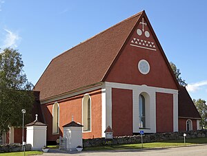
Kalix Church (Swedish: Kalix kyrka, sometimes Nederkalix kyrka) is a medieval Lutheran church in Kalix in Norrbotten County, Sweden. It belongs to the Diocese of Luleå. The church is the northernmost medieval church of Sweden.

Capitulation of Kalix
1809 battle of the Finnish War
Distance: Approx. 571 meters
Latitude and longitude: 65.85,23.16666667
The Capitulation of Kalix took place during the Finnish War, on 25 March 1809, when 3,800–4,500 Swedish and Finnish troops under Hans Henrik Gripenberg surrendered to a much larger Russian army under Pavel Andreyevich Shuvalov, as part of a large Russian threefold attack against Sweden. The capitulation was characterised by the Swedish High Command as treacherous and Gripenberg was soon court-martialed.
Weather in this IP's area
overcast clouds
-2 Celsius
-7 Celsius
-2 Celsius
-2 Celsius
1011 hPa
66 %
1011 hPa
1007 hPa
10000 meters
5.03 m/s
11.29 m/s
275 degree
100 %