Country:
Region:
City:
Latitude and Longitude:
Time Zone:
Postal Code:
IP information under different IP Channel
ip-api
Country
Region
City
ASN
Time Zone
ISP
Blacklist
Proxy
Latitude
Longitude
Postal
Route
Luminati
Country
ASN
Time Zone
Europe/Warsaw
ISP
Kujawsko-Pomorskie Centrum Kompetencji Cyfrowych Sp. z o.o. w Likwidacji
Latitude
Longitude
Postal
IPinfo
Country
Region
City
ASN
Time Zone
ISP
Blacklist
Proxy
Latitude
Longitude
Postal
Route
db-ip
Country
Region
City
ASN
Time Zone
ISP
Blacklist
Proxy
Latitude
Longitude
Postal
Route
ipdata
Country
Region
City
ASN
Time Zone
ISP
Blacklist
Proxy
Latitude
Longitude
Postal
Route
Popular places and events near this IP address

Drwęca
River in Poland
Distance: Approx. 1920 meters
Latitude and longitude: 52.99916667,18.68972222
The Drwęca (Polish: [ˈdrvɛnt͡sa]; German: Drewenz; Lithuanian: Druvinčia) is a river in northern Poland. It becomes a tributary of the Vistula river near the city of Toruń, forming a part of the city's administrative boundary. It has a length of 231 km and a basin area of 5,697 km2, all in Poland.

Toruń Główny railway station
Railway station in Toruń, Poland
Distance: Approx. 3499 meters
Latitude and longitude: 53,18.61416667
Toruń Główny railway station (English: Toruń Main Station) is the most important railway station serving the city of Toruń, in the Kuyavian-Pomeranian Voivodeship, Poland. The station is located on the Poznań–Skandawa railway and Kutno–Piła railway. The train services are operated by PKP, Przewozy Regionalne and Arriva.

Baj Pomorski Theatre
Distance: Approx. 4076 meters
Latitude and longitude: 53.0104,18.6125

Złotoria, Kuyavian-Pomeranian Voivodeship
Village in Kuyavian-Pomeranian Voivodeship, Poland
Distance: Approx. 2548 meters
Latitude and longitude: 52.98333333,18.7
Złotoria [zwɔˈtɔrja] is a village in the administrative district of Gmina Lubicz, within Toruń County, Kuyavian-Pomeranian Voivodeship, in north-central Poland. It lies approximately 8 km (5 mi) south-west of Lubicz and 8 km (5 mi) south-east of Toruń. It is located in the historic Dobrzyń Land.

Brzoza, Toruń County
Village in Kuyavian-Pomeranian Voivodeship, Poland
Distance: Approx. 3650 meters
Latitude and longitude: 52.96194444,18.68888889
Brzoza [ˈbʐɔza], meaning birch, is a village in the administrative district of Gmina Wielka Nieszawka, within Toruń County, Kuyavian-Pomeranian Voivodeship, in north-central Poland. It lies approximately 13 kilometres (8 mi) east of Wielka Nieszawka and 10 km (6 mi) south-east of Toruń. It is located in the historic region of Kuyavia.

Expressway S10 (Poland)
Road in Poland
Distance: Approx. 3164 meters
Latitude and longitude: 52.972786,18.700254
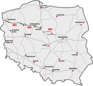
Expressway S10 or express road S10 (in Polish droga ekspresowa S10) is Polish highway which, when completed, will serve as a direct route between Szczecin and Warsaw. It has been planned to run from the interchange with Motorway A6 on the eastern outskirts of Szczecin, through Bydgoszcz and Toruń, to the interchange with express road S50 near Płock, west of Warsaw. Its planned length is 460 km (290 mi).

Siege of Thorn (1703)
Siege of the Great Northern War
Distance: Approx. 4268 meters
Latitude and longitude: 53.01666944,18.61666944
The siege of Thorn was set during the Great Northern War, between Sweden and Saxony from May to October 14, 1703. The Swedish army was commanded by Charles XII of Sweden and the Saxon by General von Kanitz. The siege ended with a victory for Sweden, and the whole garrison surrendered to the Swedes.

Medieval Town of Toruń
UNESCO World Heritage Site in Kuyavian-Pomeranian Voivodeship, Poland
Distance: Approx. 3662 meters
Latitude and longitude: 53.01,18.61944444
Medieval Town of Toruń (Polish: zespół staromiejski Torunia) is the oldest historic district of the city of Toruń. It is one of Poland's World Heritage Sites (added in 1997). According to UNESCO, its value lies in its being "a small historic trading city that preserves to a remarkable extent its original street pattern and outstanding early buildings, and which provides an exceptionally complete picture of the medieval way of life".

Toruń Castle
Castle in Poland
Distance: Approx. 4118 meters
Latitude and longitude: 53.00944444,18.61083333
Toruń Castle is a 13th- or 14th-century castle of the Teutonic Order located in Toruń, Poland. The castle is part of the Medieval Town of Toruń, one of the World Heritage Sites in Poland and Historic Monuments of Poland.

Crane Tower
Distance: Approx. 4205 meters
Latitude and longitude: 53.0085,18.6085
Crane Tower is one of the nine remaining defensive towers within the city walls of Toruń, Poland.

Confectionery Factory "Kopernik"
Confectionery company, 1763, Toruń, Poland
Distance: Approx. 3778 meters
Latitude and longitude: 53.0225,18.6425
The Confectionery Factory "Kopernik" is a firm producing gingerbread and other sweets, based in Toruń, Poland. Its headquarters is located at 34 Stanisława Żółkiewskiego street in Toruń. Still operating today, it is the oldest confectionery company in Poland, established in 1763.

Museum of Toruń Gingerbread
Food museum in Toruń, Poland
Distance: Approx. 4349 meters
Latitude and longitude: 53.01118,18.60852
The Museum of Toruń Gingerbread (Polish: Muzeum Toruńskiego Piernika) is a museum dedicated to Toruń gingerbread. It claims to be the largest gingerbread museum in Europe. Opened in 2015, it is a branch of the District Museum in Toruń and was created with the cooperation with Kopernik, the oldest Polish confectionery company.
Weather in this IP's area
broken clouds
5 Celsius
5 Celsius
5 Celsius
7 Celsius
1025 hPa
70 %
1025 hPa
1019 hPa
10000 meters
0.89 m/s
2.68 m/s
82 degree
73 %
06:47:08
16:10:36