Country:
Region:
City:
Latitude and Longitude:
Time Zone:
Postal Code:
IP information under different IP Channel
ip-api
Country
Region
City
ASN
Time Zone
ISP
Blacklist
Proxy
Latitude
Longitude
Postal
Route
Luminati
Country
Region
42
City
louny
ASN
Time Zone
Europe/Prague
ISP
ISP Alliance a.s.
Latitude
Longitude
Postal
IPinfo
Country
Region
City
ASN
Time Zone
ISP
Blacklist
Proxy
Latitude
Longitude
Postal
Route
db-ip
Country
Region
City
ASN
Time Zone
ISP
Blacklist
Proxy
Latitude
Longitude
Postal
Route
ipdata
Country
Region
City
ASN
Time Zone
ISP
Blacklist
Proxy
Latitude
Longitude
Postal
Route
Popular places and events near this IP address
Louny
Town in the Czech Republic
Distance: Approx. 260 meters
Latitude and longitude: 50.35722222,13.79694444
Louny (Czech pronunciation: [ˈlounɪ]; German: Laun) is a town in the Ústí nad Labem Region of the Czech Republic. It has about 18,000 inhabitants. It lies on the Ohře river.

Chlumčany (Louny District)
Municipality in Ústí nad Labem, Czech Republic
Distance: Approx. 3982 meters
Latitude and longitude: 50.335,13.84333333
Chlumčany (German: Klumtschan) is a municipality and village in Louny District in the Ústí nad Labem Region of the Czech Republic. It has about 600 inhabitants.

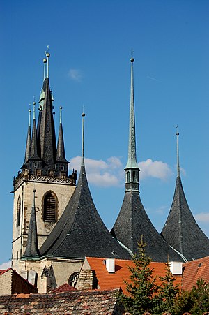
St. Nicholas Church, Louny
Church in Louny, Czech Republic
Distance: Approx. 373 meters
Latitude and longitude: 50.35725,13.79528
St. Nicholas Church in Louny (Czech: Chrám svatého Mikuláše v Lounech) is a Roman Catholic, parochial church dedicated to Saint Nicholas, located in Louny, Czech Republic. The 1517 fire destroyed the nave and damaged the tower of the original church.

Blšany u Loun
Municipality in Ústí nad Labem, Czech Republic
Distance: Approx. 3919 meters
Latitude and longitude: 50.34694444,13.85277778
Blšany u Loun (German: Pschan) is a municipality and village in Louny District in the Ústí nad Labem Region of the Czech Republic. It has about 400 inhabitants. Blšany u Loun lies approximately 5 kilometres (3 mi) east of Louny, 38 km (24 mi) south of Ústí nad Labem, and 50 km (31 mi) north-west of Prague.

Černčice (Louny District)
Municipality in Ústí nad Labem, Czech Republic
Distance: Approx. 3209 meters
Latitude and longitude: 50.36138889,13.84527778
Černčice is a municipality and village in Louny District in the Ústí nad Labem Region of the Czech Republic. It has about 1,300 inhabitants. Černčice lies approximately 4 kilometres (2 mi) east of Louny, 36 km (22 mi) south-west of Ústí nad Labem, and 52 km (32 mi) north-west of Prague.

Cítoliby
Market town in Ústí nad Labem, Czech Republic
Distance: Approx. 2931 meters
Latitude and longitude: 50.33277778,13.81222222
Cítoliby (until 1923 Citoliby; German: Zittolib) is a market town in Louny District in the Ústí nad Labem Region of the Czech Republic. It has about 1,100 inhabitants.

Dobroměřice
Municipality in Ústí nad Labem, Czech Republic
Distance: Approx. 1425 meters
Latitude and longitude: 50.37027778,13.79472222
Dobroměřice is a municipality and village in Louny District in the Ústí nad Labem Region of the Czech Republic. It has about 1,400 inhabitants. Dobroměřice lies approximately 3 kilometres (2 mi) north of Louny, 37 km (23 mi) southwest of Ústí nad Labem, and 56 km (35 mi) northwest of Prague.
Lenešice
Municipality in Ústí nad Labem, Czech Republic
Distance: Approx. 3103 meters
Latitude and longitude: 50.37527778,13.76611111
Lenešice (German: Leneschitz) is a municipality and village in Louny District in the Ústí nad Labem Region of the Czech Republic. It has about 1,400 inhabitants. Lenešice lies approximately 4 kilometres (2 mi) north-west of Louny, 37 km (23 mi) south-west of Ústí nad Labem, and 57 km (35 mi) north-west of Prague.

Líšťany (Louny District)
Municipality in Ústí nad Labem, Czech Republic
Distance: Approx. 5065 meters
Latitude and longitude: 50.3125,13.8
Líšťany is a municipality and village in Louny District in the Ústí nad Labem Region of the Czech Republic. It has about 500 inhabitants. Líšťany lies approximately 5 kilometres (3 mi) south of Louny, 43 km (27 mi) south-west of Ústí nad Labem, and 52 km (32 mi) north-west of Prague.
Obora (Louny District)
Municipality in Ústí nad Labem, Czech Republic
Distance: Approx. 4765 meters
Latitude and longitude: 50.37333333,13.86305556
Obora is a municipality and village in Louny District in the Ústí nad Labem Region of the Czech Republic. It has about 400 inhabitants. Obora lies approximately 6 kilometres (4 mi) east of Louny, 35 km (22 mi) south of Ústí nad Labem, and 50 km (31 mi) north-west of Prague.

Veltěže
Municipality in Ústí nad Labem, Czech Republic
Distance: Approx. 5343 meters
Latitude and longitude: 50.35333333,13.87527778
Veltěže is a municipality and village in Louny District in the Ústí nad Labem Region of the Czech Republic. It has about 400 inhabitants. Veltěže lies approximately 7 kilometres (4 mi) east of Louny, 37 km (23 mi) south of Ústí nad Labem, and 48 km (30 mi) north-west of Prague.
Vršovice (Louny District)
Municipality in Ústí nad Labem, Czech Republic
Distance: Approx. 3196 meters
Latitude and longitude: 50.36861111,13.84222222
Vršovice is a municipality and village in Louny District in the Ústí nad Labem Region of the Czech Republic. It has about 200 inhabitants. Vršovice lies approximately 4 kilometres (2 mi) north-east of Louny, 35 km (22 mi) south-west of Ústí nad Labem and 53 km (33 mi) north-west of Prague.
Weather in this IP's area
clear sky
7 Celsius
4 Celsius
5 Celsius
8 Celsius
1026 hPa
90 %
1026 hPa
1003 hPa
10000 meters
3.13 m/s
4.02 m/s
299 degree
4 %
07:19:20
16:19:47


