Country:
Region:
City:
Latitude and Longitude:
Time Zone:
Postal Code:
IP information under different IP Channel
ip-api
Country
Region
City
ASN
Time Zone
ISP
Blacklist
Proxy
Latitude
Longitude
Postal
Route
Luminati
Country
ASN
Time Zone
Europe/Gibraltar
ISP
Entain Corporate Services Limited
Latitude
Longitude
Postal
IPinfo
Country
Region
City
ASN
Time Zone
ISP
Blacklist
Proxy
Latitude
Longitude
Postal
Route
db-ip
Country
Region
City
ASN
Time Zone
ISP
Blacklist
Proxy
Latitude
Longitude
Postal
Route
ipdata
Country
Region
City
ASN
Time Zone
ISP
Blacklist
Proxy
Latitude
Longitude
Postal
Route
Popular places and events near this IP address

Gibraltar Defence Police
Civil police force for the MoD in Girbraltar
Distance: Approx. 391 meters
Latitude and longitude: 36.14048,-5.356641
The Gibraltar Defence Police (GDP) is a civil police force which provides a policing and security service for the Ministry of Defence in Gibraltar. Prior to 17 December 2009 it was known as the Gibraltar Services Police (GSP).
Bwin.Party Digital Entertainment
Former online gambling company
Distance: Approx. 98 meters
Latitude and longitude: 36.142633,-5.358695
Bwin.Party Digital Entertainment was an online gambling company, formed by the March 2011 merger of PartyGaming plc and Bwin Interactive Entertainment AG. Formerly the world's largest publicly traded online gambling firm, it was best known for its online poker room PartyPoker, World Poker Tour and its sports betting brand Bwin (officially styled bwin). The company was headquartered in Gibraltar and quoted on the London Stock Exchange. PartyGaming Plc was founded in 1997 with the launch of Starluck Casino.

Westside, Gibraltar
Area of Gibraltar
Distance: Approx. 375 meters
Latitude and longitude: 36.14305556,-5.35472222
Westside is an area of the British overseas territory of Gibraltar. It lies between the western slopes of the Rock of Gibraltar and the eastern shores of the Bay of Gibraltar. In 2012, it was inhabited by 26,572 people and contained 78.15% of the territory's population of 34,000.
Westside School, Gibraltar
Co-ed comprehensive school in Gibraltar
Distance: Approx. 269 meters
Latitude and longitude: 36.1442,-5.356
Westside School or simply Westside is a comprehensive school in the British territory of Gibraltar. The school opened in 1982, and was built in order to provide education to the students of the former Girls' Comprehensive School, previously spread over three different sites, and itself an amalgamation of four girls' schools: Loreto High School, St. Joseph's Secondary School, St.

St Bernard's Hospital
Hospital in Europort Avenue, Gibraltar
Distance: Approx. 58 meters
Latitude and longitude: 36.143405,-5.359491
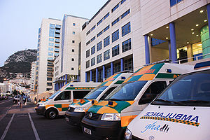
St Bernard's Hospital is the only public hospital and teaching hospital in the British overseas territory of Gibraltar.

American War Memorial, Gibraltar
Monument in Line Wall Road, Gibraltar
Distance: Approx. 397 meters
Latitude and longitude: 36.143322,-5.35445
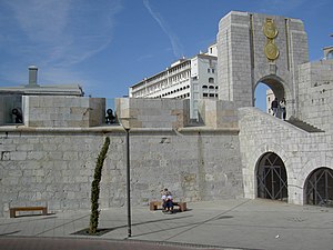
The American War Memorial (also known as the American Steps or more formally the Naval Monument at Gibraltar) is a World War I memorial in the British Overseas Territory of Gibraltar. It was built for the American Battle Monuments Commission in 1933, and incorporated into the main city wall, the Line Wall Curtain. It commemorated the successful alliance of the United States and the United Kingdom in their naval exploits in the vicinity of Gibraltar during the Great War.

Queensway, Gibraltar
Coastal road in Gibraltar
Distance: Approx. 392 meters
Latitude and longitude: 36.140894,-5.355926
Queensway is a main coastal road in the British Overseas Territory of Gibraltar and the only road servicing the oldest leisure marina on The Rock, Queensway Quay. It connects the marina with the industrial park in the southern end of the Gibraltar Harbour.

Fourth siege of Gibraltar
Conflict between Castilian and Moorish forces (1333)
Distance: Approx. 256 meters
Latitude and longitude: 36.1456,-5.3577
The fourth siege of Gibraltar, fought from June until August 1333, pitted a Christian army under King Alfonso XI of Castile against a large Moorish army led by Muhammed IV of Granada and Abd al-Malik Abd al-Wahid of Fes. It followed on immediately from the third siege of Gibraltar, fought earlier in 1333. The siege began inauspiciously with a disastrous landing by Castilian forces on the west side of Gibraltar, before developing into a stalemate in which neither side had the strength to capture Gibraltar, nor to break out or lift the siege.
Orange Bastion
Distance: Approx. 392 meters
Latitude and longitude: 36.143455,-5.354505
The Orange Bastion is one of the many bastions in the British Overseas Territory of Gibraltar, which served to protect it against its many sieges. It is located along the Line Wall Curtain and was built to protect Gibraltar Harbour against enemy attack.

Prince Albert's Front
Distance: Approx. 402 meters
Latitude and longitude: 36.1424,-5.3546
Prince Albert's Front is a curtain wall that formerly comprised part of the seafront fortifications of Gibraltar. It runs between the King's Bastion and Orange Bastion. The Front was constructed in 1842 after a report by Major General Sir John Thomas Jones recommended improving Gibraltar's seafront defences to guard against the threat of an amphibious assault.
Calpe Rowing Club
Rowing club in Gibraltar
Distance: Approx. 234 meters
Latitude and longitude: 36.14146,-5.358212
Calpe Rowing Club is a rowing club near the Port of Gibraltar, based at 6 Europort Road, Gibraltar. The boathouse is next door to the Mediterranean Rowing Club.
Mediterranean Rowing Club
Rowing club in Gibraltar
Distance: Approx. 213 meters
Latitude and longitude: 36.1416,-5.3586
Mediterranean Rowing Club is a rowing club near the Port of Gibraltar, based at 4 Europort Road, Gibraltar. The boathouse is next door to the Calpe Rowing Club.
Weather in this IP's area
few clouds
21 Celsius
21 Celsius
20 Celsius
21 Celsius
1022 hPa
75 %
1022 hPa
1021 hPa
10000 meters
2.57 m/s
100 degree
20 %
07:48:25
18:21:39
