Country:
Region:
City:
Latitude and Longitude:
Time Zone:
Postal Code:
IP information under different IP Channel
ip-api
Country
Region
City
ASN
Time Zone
ISP
Blacklist
Proxy
Latitude
Longitude
Postal
Route
Luminati
Country
ASN
Time Zone
Europe/Berlin
ISP
Bringe Informationstechnik GmbH
Latitude
Longitude
Postal
IPinfo
Country
Region
City
ASN
Time Zone
ISP
Blacklist
Proxy
Latitude
Longitude
Postal
Route
db-ip
Country
Region
City
ASN
Time Zone
ISP
Blacklist
Proxy
Latitude
Longitude
Postal
Route
ipdata
Country
Region
City
ASN
Time Zone
ISP
Blacklist
Proxy
Latitude
Longitude
Postal
Route
Popular places and events near this IP address

Wolfartsweier
Borough of Karlsruhe in Baden-Württemberg, Germany
Distance: Approx. 2885 meters
Latitude and longitude: 48.97444444,8.45361111
Wolfartsweier is a village and a quarter of Karlsruhe, Baden-Württemberg, Germany. Its population is 3,068 (2020). It was first mentioned in 1261 AD under the name of "Wolvoldeswilere".

Karlsbad (Baden)
Municipality in Baden-Württemberg, Germany
Distance: Approx. 4844 meters
Latitude and longitude: 48.91444444,8.50638889
Karlsbad (German: [ˈkaʁlsˌbaːt] ; South Franconian: Kallsbad) is a municipality in the district of Karlsruhe, in Baden-Württemberg, Germany.
Turmberg
Hil in Durlach, Germany
Distance: Approx. 5213 meters
Latitude and longitude: 48.99677778,8.48547222
The Turmberg (German: "Tower Hill") is a hill (elevation: 256 m) located in Durlach, a suburb of Karlsruhe in Germany. It is home to a castle ruin. The Turmberg can be reached by the Turmbergbahn, a funicular railway.

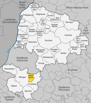
Waldbronn
Municipality in Baden-Württemberg, Germany
Distance: Approx. 2982 meters
Latitude and longitude: 48.92444444,8.47583333
Waldbronn is a municipality in the district of Karlsruhe, in Baden-Württemberg, Germany. It is situated in the northern Black Forest, 11 kilometres (7 miles) southeast of Karlsruhe.
Battle of Ettlingen
Battle of the French Revolutionary Wars
Distance: Approx. 4561 meters
Latitude and longitude: 48.94333333,8.40916667
The Battle of Ettlingen or Battle of Malsch (9 July 1796) was fought during the French Revolutionary Wars between the armies of the First French Republic and Habsburg Austria near the town of Malsch, 9 kilometres (6 mi) southwest of Ettlingen. The Austrians under Archduke Charles, Duke of Teschen tried to halt the northward advance of Jean Victor Marie Moreau's French Army of Rhin-et-Moselle along the east bank of the Rhine River. After a tough fight, the Austrian commander found that his left flank was turned.
Wattkopf
Distance: Approx. 3352 meters
Latitude and longitude: 48.93333333,8.43333333
Wattkopf is a mountain of Baden-Württemberg, Germany.

Karlsburg Castle
Distance: Approx. 5294 meters
Latitude and longitude: 48.99850278,8.47382778
Karlsburg Castle in the Durlach district of Karlsruhe characterizes the history of the Baden since 1563. Only the Prinzessinnenbau ("Princesses' wing") of the historical building still stands. Pforzheim was the residence of Margrave Charles II, until he decided in 1563 to move to Durlach.

Ettlingen Palace
Distance: Approx. 4873 meters
Latitude and longitude: 48.94027778,8.40583333
Ettlingen Palace is a baroque palace in the centre of Ettlingen, a small city in Baden-Württemberg, Germany.

Grünwettersbach
District of Karlsruhe
Distance: Approx. 1499 meters
Latitude and longitude: 48.95,8.45
Since its incorporation in 1975, Grünwettersbach has been a district in the southeast of Karlsruhe. Together with Palmbach (located further southeast), Grünwettersbach forms the administrative unit Wettersbach. Grünwettersbach is naturally located in the northern Black Forest and has been part of the Central/North Black Forest Nature Park since January 2021.

Palmbach
District of Karlsruhe
Distance: Approx. 948 meters
Latitude and longitude: 48.95,8.48333333
Palmbach is the smallest district of the Baden-Württemberg city of Karlsruhe. The Waldensian town of Palmbach is located on the southeastern edge of the urban area and was incorporated into the city of Karlsruhe on January 1, 1975. Naturally, it is located in the northern Black Forest, is the highest residential area in Karlsruhe and has been part of the Central/North Black Forest Nature Park since January 2021.

Hohenwettersbach
District of Karlsruhe
Distance: Approx. 1766 meters
Latitude and longitude: 48.96666667,8.46666667
Hohenwettersbach is a district of the Baden-Württemberg city of Karlsruhe. It is located east of Durlach on the mountain between Wolfartsweier and Grünwettersbach. Since January 2021, Hohenwettersbach has been part of the Central/North Black Forest Nature Park.

Stupferich
District of Karlsruhe
Distance: Approx. 2163 meters
Latitude and longitude: 48.95,8.5
Stupferich is a district of Karlsruhe. The high-altitude district is one of the Bergdörfer (mountain villages) of Karlsruhe and is located about 100 meters above the city center in the hilly landscape on the southeastern edge of the city area. In terms of natural geography, it belongs to the southern Kraichgau and has been part of the Central/North Black Forest Nature Park since January 2021.
Weather in this IP's area
light rain
6 Celsius
3 Celsius
5 Celsius
8 Celsius
1015 hPa
88 %
1015 hPa
987 hPa
10000 meters
4.81 m/s
11.4 m/s
250 degree
100 %
07:39:06
16:43:28


