93.189.4.203 - IP Lookup: Free IP Address Lookup, Postal Code Lookup, IP Location Lookup, IP ASN, Public IP
Country:
Region:
City:
Location:
Time Zone:
Postal Code:
IP information under different IP Channel
ip-api
Country
Region
City
ASN
Time Zone
ISP
Blacklist
Proxy
Latitude
Longitude
Postal
Route
Luminati
Country
ASN
Time Zone
Europe/London
ISP
Real Hosts Limited
Latitude
Longitude
Postal
IPinfo
Country
Region
City
ASN
Time Zone
ISP
Blacklist
Proxy
Latitude
Longitude
Postal
Route
IP2Location
93.189.4.203Country
Region
england
City
carshalton
Time Zone
Europe/London
ISP
Language
User-Agent
Latitude
Longitude
Postal
db-ip
Country
Region
City
ASN
Time Zone
ISP
Blacklist
Proxy
Latitude
Longitude
Postal
Route
ipdata
Country
Region
City
ASN
Time Zone
ISP
Blacklist
Proxy
Latitude
Longitude
Postal
Route
Popular places and events near this IP address

Carshalton
Suburb of London
Distance: Approx. 345 meters
Latitude and longitude: 51.3652,-0.1676
Carshalton ( kar-SHAWL-tən, -SHOL-) is a town, with a historic village centre, in south London, England, within the London Borough of Sutton. It is situated 9.5 miles (15.3 km) south-southwest of Charing Cross, in the valley of the River Wandle, one of the sources of which is Carshalton Ponds in the middle of the village. Prior to the creation of Greater London in 1965, Carshalton was in the administrative county of Surrey.

Carshalton railway station
National Rail station in London, England
Distance: Approx. 116 meters
Latitude and longitude: 51.3686,-0.1659
Carshalton railway station is a railway station at Carshalton in the London Borough of Sutton in South London. It is located between Sutton and Hackbridge. The station is served by Southern and Thameslink.

Carshalton Urban District
Local government district in England
Distance: Approx. 562 meters
Latitude and longitude: 51.3646,-0.162
Carshalton was a local government district in north east Surrey from 1883 to 1965 around the town of Carshalton. The parish of Carshalton adopted the Local Government Act 1858 in 1883 and a local board was formed to govern the town. The Local Government Act 1894 reconstituted the area as an urban district, and an elected urban district council replaced the local board.
Carshalton Athletic F.C.
Association football club in London, England
Distance: Approx. 337 meters
Latitude and longitude: 51.36969722,-0.17180833
Carshalton Athletic Football Club is an English football club based in Carshalton in the London Borough of Sutton. They currently play in the Isthmian League Premier Division and are based at the War Memorial Sports Ground. The club also field a women's team playing in the London and South East Regional Women's Premier Division and have one of the biggest community clubs in England with over 40 junior teams.

St Philomena's Catholic High School for Girls
Voluntary aided school in Carshalton, Greater London, England
Distance: Approx. 339 meters
Latitude and longitude: 51.365431,-0.169129
St Philomena's Catholic High School for Girls is a school for girls (aged 11–18) in Carshalton in the London Borough of Sutton.

Grove Park (Sutton)
Distance: Approx. 390 meters
Latitude and longitude: 51.3667,-0.1625
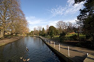
The Grove Park, or The Grove is a public park in Carshalton in the London Borough of Sutton. It is situated close to Carshalton Village in the area approximately bounded by the High Street, North Street and Mill Lane. The southwest corner of the park abuts one of Carshalton's ponds (Lower Pond) from where water flows through the park as the river Wandle.

Carshalton High School for Girls
Academy in Carshalton, London, England
Distance: Approx. 192 meters
Latitude and longitude: 51.36963,-0.16927
Carshalton High School for Girls is an academy school for 11- to 18-year-old girls in Carshalton, Sutton, England. The headteacher is Peter Baumann-Winn It is a popular school, and has achieved many awards for efforts from both students and staff. There are many resources for students at the school, including a drama and dance studio and a brand new Sixth Form common room.

The Wrythe
District of Carshalton, South London, United Kingdom
Distance: Approx. 667 meters
Latitude and longitude: 51.37416667,-0.16555556
The Wrythe is a district of Carshalton, South London in the London Borough of Sutton. It is 9.3 miles (15.0 km) south of Charing Cross and is surrounded by the adjacent areas of Hackbridge to the east, Morden and Mitcham to the north, and Sutton to the west. The area is commonly referred to as Wrythe Green, an old village green at the centre of the neighbourhood.
The Spinney Local Nature Reserve
Nature reserve in England
Distance: Approx. 855 meters
Latitude and longitude: 51.3752,-0.1621
The Spinney, Carshalton (or Nightingale Road Bird Sanctuary) is a 0.4 hectare local nature reserve in Carshalton in the London Borough of Sutton, England. It is owned by Sutton Council and managed by the council and Sutton Nature Conservation Volunteers. It used to be managed by the London Wildlife Trust.
Sutton Ecology Centre Grounds
Distance: Approx. 278 meters
Latitude and longitude: 51.3661,-0.1656
Sutton Ecology Centre Grounds is a 1.3 hectare Local Nature Reserve and Site of Borough Importance for Nature Conservation, Grade 1, in Carshalton in the London Borough of Sutton. It is owned by Sutton Council and managed by the Council together with the Friends of Sutton Ecology Centre. The area was recorded as an orchard called Cook's Orchard from 1590.

Charles Cryer Theatre
Distance: Approx. 608 meters
Latitude and longitude: 51.365941,-0.159602
The Charles Cryer Theatre is a studio theatre located in the High Street in Carshalton in the London Borough of Sutton. The theatre is named after the man who led the campaign to open the Secombe Theatre in neighbouring Sutton. It was opened by Prince Edward in 1991.

Carshalton Council Offices
Municipal building in London, England
Distance: Approx. 544 meters
Latitude and longitude: 51.3647,-0.1622
The Carshalton Council Offices is a former municipal building on The Square, Carshalton, London. The structure, which was briefly the headquarters of Carshalton Urban District Council before becoming a public library, is a Grade II listed building.
Weather in this IP's area
clear sky
3 Celsius
1 Celsius
1 Celsius
4 Celsius
1041 hPa
83 %
1041 hPa
1032 hPa
10000 meters
1.71 m/s
1.52 m/s
199 degree
7 %

