93.189.159.184 - IP Lookup: Free IP Address Lookup, Postal Code Lookup, IP Location Lookup, IP ASN, Public IP
Country:
Region:
City:
Location:
Time Zone:
Postal Code:
IP information under different IP Channel
ip-api
Country
Region
City
ASN
Time Zone
ISP
Blacklist
Proxy
Latitude
Longitude
Postal
Route
Luminati
Country
Region
bw
City
karlsruhe
ASN
Time Zone
Europe/Berlin
ISP
TelemaxX Telekommunikation GmbH
Latitude
Longitude
Postal
IPinfo
Country
Region
City
ASN
Time Zone
ISP
Blacklist
Proxy
Latitude
Longitude
Postal
Route
IP2Location
93.189.159.184Country
Region
baden-wurttemberg
City
gaggenau
Time Zone
Europe/Berlin
ISP
Language
User-Agent
Latitude
Longitude
Postal
db-ip
Country
Region
City
ASN
Time Zone
ISP
Blacklist
Proxy
Latitude
Longitude
Postal
Route
ipdata
Country
Region
City
ASN
Time Zone
ISP
Blacklist
Proxy
Latitude
Longitude
Postal
Route
Popular places and events near this IP address
Rastatt (district)
District in Baden-Württemberg, Germany
Distance: Approx. 4641 meters
Latitude and longitude: 48.8,8.27
Rastatt is a Landkreis (district) in the west of Baden-Württemberg, Germany. Neighbouring districts are (from north clockwise) Karlsruhe, Calw, Freudenstadt and the Ortenaukreis. To the west it borders the French département Bas-Rhin.
Merkur Tower
Distance: Approx. 5533 meters
Latitude and longitude: 48.76446,8.28056
The Merkur Tower (German: Merkur) is an observation tower on the Merkur near Baden-Baden, at 8°16'50" E and 48°45'52" N. The tower has been in use since 8 April 1950 by the former SWF (now SWR) as a transmission tower for FM-radio and, since 1953, television. At the end of the 1970s the tower was completely renovated and its radio equipment modified. An underground equipment room for radiotechnical equipment was built, and a new tower was constructed, adjoining the older tower.

Gaggenau
Town in Baden-Württemberg, Germany
Distance: Approx. 1104 meters
Latitude and longitude: 48.80388889,8.31944444
Gaggenau is a town in the district of Rastatt, in Baden-Württemberg, Germany. It is located some 8 km northeast of Baden-Baden.

Gernsbach
Town in Baden-Württemberg, Germany
Distance: Approx. 4082 meters
Latitude and longitude: 48.76333333,8.33416667
Gernsbach (German pronunciation: [ˈɡɛʁnsbax] ) is a town in the district of Rastatt, in Baden-Württemberg, Germany. It is located on the river Murg, 7 km (4.35 mi) east of Baden-Baden in the Black Forest. Twin towns are Baccarat in France and Pergola, Marche in Italy.

Loffenau
Town in southwestern Germany
Distance: Approx. 4905 meters
Latitude and longitude: 48.7725,8.38555556
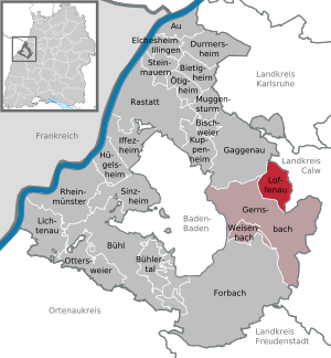
Loffenau is a town in the district of Rastatt in Baden-Württemberg in Germany.
Alt Eberstein
Distance: Approx. 4939 meters
Latitude and longitude: 48.783889,8.270556
The ruins of Alt-Eberstein are the remains of the former Schloss Eberstein (Eberstein Castle), located on a hill near the town of Ebersteinburg and directly upstream of the modern city of Baden-Baden, in the state of Baden-Württemberg, Germany. The original structure was built in 1100 as the primary residence of the Counts of Eberstein, but by the end of the 16th century had been abandoned and much of the castle was torn down to provide materials for other structures. Presently it is a German national monument and a State Palace of Baden-Wuerttemberg.
Bad Rotenfels
Stadtteil of Gaggenau in Baden-Württemberg, Germany
Distance: Approx. 1104 meters
Latitude and longitude: 48.80388889,8.31944444
Bad Rotenfels is a district in the city of Gaggenau, district of Rastatt, in Baden-Württemberg, Germany. It is located some 8 km northeast of Baden-Baden.

Ebersteinburg
Ortsteil of Baden-Baden in Baden-Württemberg, Germany
Distance: Approx. 5149 meters
Latitude and longitude: 48.78,8.27
Ebersteinburg is an Ortsteil of Baden-Baden, Germany. At 426m in elevation it lies between the valleys of the Murg and Oos rivers. The village has a population of 1,300 and since 1972 has been part of the city of Baden-Baden.
Bernstein (Northern Black Forest)
Mountain in Gaggenau, Baden-Württemberg, Germany
Distance: Approx. 4759 meters
Latitude and longitude: 48.8108,8.3961
The Bernstein is a mountain, 693.5 m above sea level (NHN), in the Northern Black Forest within the borough of Gaggenau (estate of Rotenfels), and the borough of Bad Herrenalb, (estate of Bernbach). It is part of the ridge that borders the lower Murg valley on its eastern side. The summit of this mountain is formed by a six-metre-high crag made of bunter sandstone with a flat top, 25 m² in area, from where there are good views.
Mahlberg (mountain)
Mountain in Germany
Distance: Approx. 5105 meters
Latitude and longitude: 48.8357083,8.377
The Mahlberg is a mountain in the northwest of the Northern Black Forest and, at 612.5 m above sea level (NHN), is the highest point in the Baden-Württemberg county of Karlsruhe and the parish of Völkersbach. Its eastern side belongs to the municipality of Malsch in Karlsruhe and the western side to the borough of Gaggenau in the county of Rastatt.

Staufenberg (Gernsbach)
Stadtteil of Gernsbach in Baden-Württemberg, Germany
Distance: Approx. 4211 meters
Latitude and longitude: 48.76611111,8.30777778
Staufenberg is a village in Baden-Württemberg, Germany. It is administratively part of the town of Gernsbach in the Rastatt district.

Scheuern (Gernsbach)
Stadtteil of Gernsbach in Baden-Württemberg, Germany
Distance: Approx. 5056 meters
Latitude and longitude: 48.75555556,8.3475
Scheuern is a suburb of the town of Gernsbach in the Rastatt district, Baden-Württemberg, Germany.
Weather in this IP's area
broken clouds
4 Celsius
3 Celsius
3 Celsius
5 Celsius
1024 hPa
84 %
1024 hPa
977 hPa
10000 meters
2.06 m/s
210 degree
75 %


