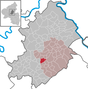
Country:
 Germany
Region:
City:
Latitude and Longitude:
Time Zone:
Postal Code:
IP information under different IP Channel
ip-api
Country
Region
City
ASN
Time Zone
ISP
Blacklist
Proxy
Latitude
Longitude
Postal
Route
IPinfo
Country
Region
City
ASN
Time Zone
ISP
Blacklist
Proxy
Latitude
Longitude
Postal
Route
MaxMind
Country
Region
City
ASN
Time Zone
ISP
Blacklist
Proxy
Latitude
Longitude
Postal
Route
Luminati
Country
DEASN
Time Zone
Europe/Berlin
ISP
VSE NET GmbH
Latitude
Longitude
Postal
db-ip
Country
Region
City
ASN
Time Zone
ISP
Blacklist
Proxy
Latitude
Longitude
Postal
Route
ipdata
Country
Region
City
ASN
Time Zone
ISP
Blacklist
Proxy
Latitude
Longitude
Postal
Route
Popular places and events near this IP address

Hunsrück
Mountain range in Germany
Distance: Approx. 1859 meters
Latitude and longitude: 50,7.5
The Hunsrück (German pronunciation: [ˈhʊnsʁʏk] ) is a long, triangular, pronounced upland in Rhineland-Palatinate, Germany. It is bounded by the valleys of the Moselle-Saar (north-to-west), the Nahe (south), and the Rhine (east). It is continued by the Taunus mountains, past the Rhine and by the Eifel past the Moselle.
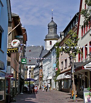
Simmern im Hunsrück
Town in Rhineland-Palatinate, Germany
Distance: Approx. 1193 meters
Latitude and longitude: 49.98333333,7.51666667
Simmern (German pronunciation: [ˈzɪmən]; officially Simmern/Hunsrück) is a town of roughly 7,600 inhabitants (2013) in Rhineland-Palatinate, Germany, the district seat of the Rhein-Hunsrück-Kreis, and the seat of the Verbandsgemeinde Simmern-Rheinböllen. In the Rhineland-Palatinate state development plan, it is set out as a middle centre.

Schönborn family
Noble family of the Holy Roman Empire
Distance: Approx. 3451 meters
Latitude and longitude: 49.9572,7.474
The House of Schönborn [ˈʃøːnbɔrn] is the name of an ancient noble and formerly sovereign family of the Holy Roman Empire. As a former ruling and mediatized family, it belongs to the Hochadel (high nobility). Various members of the family have held high offices of the Roman Catholic Church and the Holy Roman Empire over the course of centuries, including as bishops, prince bishops, cardinals and prince-electors.
Fronhofen
Municipality in Rhineland-Palatinate, Germany
Distance: Approx. 2644 meters
Latitude and longitude: 49.99168,7.46543
Fronhofen is an Ortsgemeinde – a municipality belonging to a Verbandsgemeinde, a kind of collective municipality – in the Rhein-Hunsrück-Kreis district in Rhineland-Palatinate, Germany. It belongs to the Verbandsgemeinde Simmern-Rheinböllen, whose seat is in Simmern.
Keidelheim
Municipality in Rhineland-Palatinate, Germany
Distance: Approx. 870 meters
Latitude and longitude: 49.99111111,7.49944444
Keidelheim is an Ortsgemeinde – a municipality belonging to a Verbandsgemeinde, a kind of collective municipality – in the Rhein-Hunsrück-Kreis (district) in Rhineland-Palatinate, Germany. It belongs to the Verbandsgemeinde Simmern-Rheinböllen, whose seat is in Simmern.
Schönborn, Rhein-Hunsrück
Municipality in Rhineland-Palatinate, Germany
Distance: Approx. 3317 meters
Latitude and longitude: 49.95833333,7.47472222
Schönborn is an Ortsgemeinde – a municipality belonging to a Verbandsgemeinde, a kind of collective municipality – in the Rhein-Hunsrück-Kreis (district) in Rhineland-Palatinate, Germany. It belongs to the Verbandsgemeinde Simmern-Rheinböllen, whose seat is in Simmern.

Külz
Municipality in Rhineland-Palatinate, Germany
Distance: Approx. 2713 meters
Latitude and longitude: 50.0075,7.49555556
Külz is an Ortsgemeinde – a municipality belonging to a Verbandsgemeinde, a kind of collective municipality – in the Rhein-Hunsrück-Kreis (district) in Rhineland-Palatinate, Germany. It belongs to the Verbandsgemeinde Simmern-Rheinböllen, whose seat is in Simmern.

Kümbdchen
Municipality in Rhineland-Palatinate, Germany
Distance: Approx. 1175 meters
Latitude and longitude: 49.99138889,7.51055556
Kümbdchen is an Ortsgemeinde – a municipality belonging to a Verbandsgemeinde, a kind of collective municipality – in the Rhein-Hunsrück-Kreis (district) in Rhineland-Palatinate, Germany. It belongs to the Verbandsgemeinde Simmern-Rheinböllen, whose seat is in Simmern.
Nannhausen
Municipality in Rhineland-Palatinate, Germany
Distance: Approx. 1705 meters
Latitude and longitude: 49.97555556,7.47944444
Nannhausen is an Ortsgemeinde – a municipality belonging to a Verbandsgemeinde, a kind of collective municipality – in the Rhein-Hunsrück-Kreis (district) in Rhineland-Palatinate, Germany. It belongs to the Verbandsgemeinde Simmern-Rheinböllen, whose seat is in Simmern.

Ohlweiler
Municipality in Rhineland-Palatinate, Germany
Distance: Approx. 1916 meters
Latitude and longitude: 49.96611111,7.49861111
Ohlweiler is an Ortsgemeinde – a municipality belonging to a Verbandsgemeinde, a kind of collective municipality – in the Rhein-Hunsrück-Kreis (district) in Rhineland-Palatinate, Germany. It belongs to the Verbandsgemeinde Simmern-Rheinböllen, whose seat is in Simmern.
Simmern (Verbandsgemeinde)
Distance: Approx. 1217 meters
Latitude and longitude: 49.983,7.517
Simmern is a former Verbandsgemeinde ("collective municipality") in the Rhein-Hunsrück district, in Rhineland-Palatinate, Germany. Its seat was in Simmern. On 1 January 2020 it was merged into the new Verbandsgemeinde Simmern-Rheinböllen.
Simmern-Rheinböllen
Distance: Approx. 1478 meters
Latitude and longitude: 49.98,7.52
Simmern-Rheinböllen is a Verbandsgemeinde ("collective municipality") in the Rhein-Hunsrück-Kreis, Rhineland-Palatinate, Germany. The seat of the Verbandsgemeinde is in Simmern. It was formed on 1 January 2020 by the merger of the former Verbandsgemeinden Simmern and Rheinböllen.
Weather in this IP's area
clear sky
13 Celsius
13 Celsius
11 Celsius
14 Celsius
1020 hPa
88 %
1020 hPa
976 hPa
10000 meters
2.57 m/s
70 degree
07:13:46
19:33:00