Country:
Region:
City:
Latitude and Longitude:
Time Zone:
Postal Code:
IP information under different IP Channel
ip-api
Country
Region
City
ASN
Time Zone
ISP
Blacklist
Proxy
Latitude
Longitude
Postal
Route
Luminati
Country
Region
ba
City
beirut
ASN
Time Zone
Asia/Beirut
ISP
Moscanet SAL
Latitude
Longitude
Postal
IPinfo
Country
Region
City
ASN
Time Zone
ISP
Blacklist
Proxy
Latitude
Longitude
Postal
Route
db-ip
Country
Region
City
ASN
Time Zone
ISP
Blacklist
Proxy
Latitude
Longitude
Postal
Route
ipdata
Country
Region
City
ASN
Time Zone
ISP
Blacklist
Proxy
Latitude
Longitude
Postal
Route
Popular places and events near this IP address

United Nations Economic and Social Commission for Western Asia
Regional commissions of the United Nations Economic and Social Council
Distance: Approx. 335 meters
Latitude and longitude: 33.8946,35.5021
The United Nations Economic and Social Commission for West Asia (ESCWA; Arabic: الإسكوا) is one of five regional commissions under the jurisdiction of the United Nations Economic and Social Council. The role of the Commission is to promote economic and social development of Western Asia through regional and subregional cooperation and integration. The Commission is composed of 21 member states, all from the regions of North Africa and the Middle East.

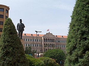
Grand Serail of Beirut
Historic site in Beirut, Lebanon
Distance: Approx. 500 meters
Latitude and longitude: 33.895926,35.500934
The Grand Serail (Arabic: السراي الكبير, al-Sarāy al-Kabir; also known as the Government Palace) is the headquarters of the Prime Minister of Lebanon. It is situated atop a hill in downtown Beirut a few blocks away from the Lebanese Parliament building. The Grand Serail is a historic building, the most important of three Ottoman monuments on the Serail hill, the others being the Council for Development and Reconstruction and the Hamidiyyeh clock tower.

National Evangelical Church of Beirut
Distance: Approx. 357 meters
Latitude and longitude: 33.89471,35.501477
The National Evangelical Church of Beirut (NEC) is a reformed church in Beirut, member of the National Evangelical Church Union of Lebanon.

Ministry of Finance (Lebanon)
Distance: Approx. 484 meters
Latitude and longitude: 33.89583333,35.50361111
The Ministry of Finance (MOF; Arabic: وزارة المالية) is a ministry of the government of Lebanon.

Gibran Khalil Gibran Garden
Public garden in Beirut, Lebanon
Distance: Approx. 348 meters
Latitude and longitude: 33.8942113,35.5003362
The Gibran Khalil Gibran Garden (Arabic: حديقة جبران خليل جبران) is a 6,000-square-meter public garden in the Centre Ville area of Beirut, Lebanon, facing the UN House, the headquarters of ESCWA, the United Nations Economic and Social Commission for Western Asia. The garden, which is named in honor of the Lebanese–American writer, poet and visual artist Kahlil Gibran, features two circular lawns, a fountain, and modern sculpture, including a bust of Gibran. The garden is often used as a venue for peaceful and democratic demonstrations and sit-ins.

Maronite Cathedral of Saint George, Beirut
Church in Beirut, Lebanon
Distance: Approx. 489 meters
Latitude and longitude: 33.895272,35.50531
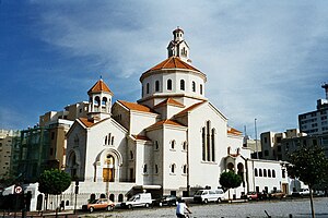
Saint George Maronite Cathedral (Arabic: كاتدرائية مار جرجس للموارنة) is the cathedral of the Maronite Catholic Archeparchy of Beirut, Archdiocese of the city of Beirut, Lebanon. Its construction, with a Neoclassical facade, interior and plan inspired by the Basilica di Santa Maria Maggiore, began in 1884 and ended in 1894. The cathedral was heavily hit and shelled during the Lebanese civil war and was plundered and defaced.

Cathedral of Saint Elias and Saint Gregory the Illuminator
Church in Beirut, Lebanon
Distance: Approx. 501 meters
Latitude and longitude: 33.89294,35.50758
The Cathedral of Saint Elias and Saint Gregory the Illuminator (Armenian: Սուրբ Եղիա – Սուրբ Գրիգոր Լուսաւորիչ եկեղեցի) is a cathedral of the Armenian Catholic Church in Debbas Square in downtown Beirut, Lebanon. Construction was funded in 1928 by Pope Pius XI. It is the cathedra of the Armenian Catholic Patriarchate of Cilicia. The order in which the two eponymous saints are presented in the cathedral's name, Saint Elias and Saint Gregory the Illuminator, is not fixed.

Zuqaq al-Blat
Quarter of Beirut
Distance: Approx. 382 meters
Latitude and longitude: 33.89222222,35.49833333
Zuqaq al-Blat (Arabic: زقاق البلاط) is one of the twelve quarters of Beirut.

Siege of Beirut
Israeli military siege during the 1982 Lebanon War
Distance: Approx. 287 meters
Latitude and longitude: 33.8897,35.5003
During the 1982 Lebanon War, the city of Beirut was besieged by Israel following the breakdown of the ceasefire that had been imposed by the United Nations amidst the Lebanese Civil War. Beginning in mid-June, the two-month-long siege resulted in the expulsion of the Palestinian Liberation Organization (PLO) from Beirut and the rest of Lebanon.

Riad Al Solh Square
Square in Beirut, Lebanon
Distance: Approx. 393 meters
Latitude and longitude: 33.89511111,35.50288889
Riad Al Solh Square (Arabic: ساحة رياض الصلح) is a square in the heart of downtown Beirut, Lebanon.

Maronite Catholic Archeparchy of Beirut
Eastern Catholic jurisdiction in Lebanon
Distance: Approx. 448 meters
Latitude and longitude: 33.895,35.505
The Archeparchy of Beirut (in Latin: Archeparchia Berytensis Maronitarum) is an archeparchial seat of the Maronite Church immediately subject to the Holy See in Lebanon. As of 2012, there were 232,000 baptized. It is currently ruled by Archeparch Paul Abdel Sater.

The Egg, Beirut
Distance: Approx. 393 meters
Latitude and longitude: 33.893495,35.505989
The Egg, or the Dome, is an unfinished cinema building in Beirut, Lebanon. Its construction began in 1965 but was interrupted with the outbreak the Lebanese Civil War in 1975 and the horse-shoe shaped dome that remains today is now a landmark in Beirut. Youssef El Zein, founder of GroupZein S.A.L, was assigned for the interior works.
Weather in this IP's area
few clouds
23 Celsius
23 Celsius
21 Celsius
23 Celsius
1018 hPa
64 %
1018 hPa
1012 hPa
10000 meters
3.09 m/s
20 degree
20 %
06:01:07
16:42:03