93.180.144.199 - IP Lookup: Free IP Address Lookup, Postal Code Lookup, IP Location Lookup, IP ASN, Public IP
Country:
 Bosnia & Herzegovina
Region:
City:
Location:
Time Zone:
Postal Code:
ISP:
ASN:
language:
User-Agent:
Proxy IP:
Blacklist:
IP information under different IP Channel
ip-api
Country
Region
City
ASN
Time Zone
ISP
Blacklist
Proxy
Latitude
Longitude
Postal
Route
db-ip
Country
Region
City
ASN
Time Zone
ISP
Blacklist
Proxy
Latitude
Longitude
Postal
Route
IPinfo
Country
Region
City
ASN
Time Zone
ISP
Blacklist
Proxy
Latitude
Longitude
Postal
Route
IP2Location
93.180.144.199Country
baRegion
republika srpska
City
kozarska dubica
Time Zone
Europe/Sarajevo
ISP
Language
User-Agent
Latitude
Longitude
Postal
ipdata
Country
Region
City
ASN
Time Zone
ISP
Blacklist
Proxy
Latitude
Longitude
Postal
Route
Popular places and events near this IP address
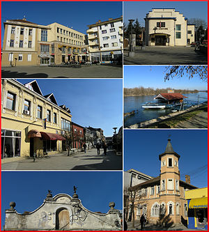
Dubica, Bosnia and Herzegovina
Town and municipality
Distance: Approx. 439 meters
Latitude and longitude: 45.18055556,16.81055556
Kozarska Dubica (Serbian Cyrillic: Козарска Дубица), formerly Bosanska Dubica (Serbian Cyrillic: Босанска Дубица) is a town and municipality in Republika Srpska, Bosnia and Herzegovina. As of 2013, it has a population of 21,542 inhabitants, while the town of Kozarska Dubica has a population of 11,566 inhabitants.

Hadžibajir
Village in Republika Srpska, Bosnia and Herzegovina
Distance: Approx. 3026 meters
Latitude and longitude: 45.15,16.81666667
Hadžibajir (Serbian Cyrillic: Хаџибајир) is a village in the municipality of Kozarska Dubica, Republika Srpska, Bosnia and Herzegovina.
Mrazovci
Village in Republika Srpska, Bosnia and Herzegovina
Distance: Approx. 4794 meters
Latitude and longitude: 45.16666667,16.75
Mrazovci (Serbian Cyrillic: Мразовци) is a village in the municipality of Kozarska Dubica, Republika Srpska, Bosnia and Herzegovina.
Novoselci, Bosnia and Herzegovina
Village in Republika Srpska, Bosnia and Herzegovina
Distance: Approx. 2331 meters
Latitude and longitude: 45.16666667,16.78333333
Novoselci (Serbian Cyrillic: Новоселци) is a village in the municipality of Kozarska Dubica, Republika Srpska, Bosnia and Herzegovina.
Parnice
Village in Republika Srpska, Bosnia and Herzegovina
Distance: Approx. 3125 meters
Latitude and longitude: 45.14916667,16.80166667
Parnice (Serbian Cyrillic: Парнице) is a village in the municipality of Kozarska Dubica, Republika Srpska, Bosnia and Herzegovina.
Sključani
Village in Republika Srpska, Bosnia and Herzegovina
Distance: Approx. 3516 meters
Latitude and longitude: 45.15,16.83333333
Sključani (Serbian Cyrillic: Скључани) is a village in the municipality of Kozarska Dubica, Republika Srpska, Bosnia and Herzegovina.
Verija
Village in Republika Srpska, Bosnia and Herzegovina
Distance: Approx. 3434 meters
Latitude and longitude: 45.18333333,16.76666667
Verija (Serbian Cyrillic: Верија) is a village in the municipality of Kozarska Dubica, Republika Srpska, Bosnia and Herzegovina.
Vrioci
Village in Republika Srpska, Bosnia and Herzegovina
Distance: Approx. 4719 meters
Latitude and longitude: 45.18333333,16.75
Vrioci (Serbian Cyrillic: Вриоци) is a village in the municipality of Kozarska Dubica, Republika Srpska, Bosnia and Herzegovina.
Operation Una
Military offensive by the Croatian Army against the Army of Republika Srpska
Distance: Approx. 721 meters
Latitude and longitude: 45.179912,16.801419
Operation Una (Croatian: Operacija Una) was a military offensive conducted by the Croatian Army (Hrvatska vojska – HV) against the Army of Republika Srpska (Vojska Republike Srpske – VRS) in western Bosnia and Herzegovina on 18–19 September 1995, during the Bosnian War. The operation entailed a crossing of the Una and Sava rivers to establish bridgeheads at Novi Grad, Bosanska Dubica, Bosanska Kostajnica and opposite Jasenovac to allow for a subsequent advance towards Prijedor and Banja Luka. The operation was planned in a matter of hours following a meeting between Croatian President Franjo Tuđman and U.S. diplomat Richard Holbrooke, during which Holbrooke urged Tuđman to seize Prijedor and threaten to capture Banja Luka from the VRS, short of actually seizing the city, as he believed such a development would force Bosnian Serb leaders to the negotiating table.
Battle of Dubica
1513 battle between Croatia and the Ottoman Empire
Distance: Approx. 1639 meters
Latitude and longitude: 45.189271,16.798529
The Battle of Dubica (Croatian: Bitka kod Dubice) was fought on 16 August 1513 between the Kingdom of Croatia and the Ottoman Empire. The Croatian army was commanded by Petar Berislavić, Ban of Croatia, while the Ottoman army was mostly composed of forces from the Sanjak of Bosnia under the command of Sanjak-bey Junuz-aga. The two armies clashed near the town of Dubica in central Croatia, between the Sava and Una rivers.
Dub Radio
Bosnian radio station
Distance: Approx. 1044 meters
Latitude and longitude: 45.18333333,16.8
Dub Radio (Serbian Cyrillic: Дуб Радио) is a Bosnian local public radio station, broadcasting from Kozarska Dubica, Bosnia and Herzegovina. The station was launched as Radio Bosanska Dubica in 1972 by the municipal council of Bosanska Dubica. In Yugoslavia and in SR Bosnia and Herzegovina, it was part of local/municipal Radio Sarajevo network affiliate.
Radio Feniks
Bosnian radio station
Distance: Approx. 1044 meters
Latitude and longitude: 45.18333333,16.8
Radio Feniks is a Bosnian local commercial radio station, broadcasting from Kozarska Dubica, Bosnia and Herzegovina. This radio station broadcasts a variety of programs such as music, talk show and local news. The owner of the radio station is the company FENIKS-ALFA d.o.o.
Weather in this IP's area
overcast clouds
8 Celsius
8 Celsius
8 Celsius
8 Celsius
1031 hPa
53 %
1031 hPa
1010 hPa
10000 meters
1.18 m/s
2.54 m/s
78 degree
94 %