93.159.251.0 - IP Lookup: Free IP Address Lookup, Postal Code Lookup, IP Location Lookup, IP ASN, Public IP
Country:
Region:
City:
Location:
Time Zone:
Postal Code:
IP information under different IP Channel
ip-api
Country
Region
City
ASN
Time Zone
ISP
Blacklist
Proxy
Latitude
Longitude
Postal
Route
Luminati
Country
Region
nw
City
aachen
ASN
Time Zone
Europe/Berlin
ISP
RelAix Networks GmbH
Latitude
Longitude
Postal
IPinfo
Country
Region
City
ASN
Time Zone
ISP
Blacklist
Proxy
Latitude
Longitude
Postal
Route
IP2Location
93.159.251.0Country
Region
nordrhein-westfalen
City
aachen
Time Zone
Europe/Berlin
ISP
Language
User-Agent
Latitude
Longitude
Postal
db-ip
Country
Region
City
ASN
Time Zone
ISP
Blacklist
Proxy
Latitude
Longitude
Postal
Route
ipdata
Country
Region
City
ASN
Time Zone
ISP
Blacklist
Proxy
Latitude
Longitude
Postal
Route
Popular places and events near this IP address

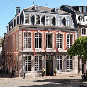
Aachen
City in North Rhine-Westphalia, Germany
Distance: Approx. 105 meters
Latitude and longitude: 50.77555556,6.08361111
Aachen ( AH-kən, German: [ˈaːxn̩] ; Aachen dialect: Oche [ˈɔːxə]; Dutch: Aken [ˈaːkə(n)] ; French: Aix-la-Chapelle; Latin: Aquae Granni or Aquisgranum) is the 13th-largest city in North Rhine-Westphalia and the 27th-largest city of Germany, with around 261,000 inhabitants. Aachen is located at the northern foothills of the High Fens and the Eifel Mountains. It sits on the Wurm River, a tributary of the Rur, and together with Mönchengladbach, it is the only larger German city in the drainage basin of the Meuse.

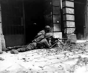
Battle of Aachen
Battle on the Western Front of World War II
Distance: Approx. 22 meters
Latitude and longitude: 50.77638889,6.08333333
The Battle of Aachen was a battle of World War II, fought by American and German forces in and around Aachen, Germany, between 12 September and 21 October 1944. The city had been incorporated into the Siegfried Line, the main defensive network on Germany's western border; the Allies had hoped to capture it quickly and advance into the industrialized Ruhr Basin. Although most of Aachen's civilian population was evacuated before the battle began, much of the city was destroyed and both sides suffered heavy losses.

Palace of Aachen
Residence of Charlemagne from ca. 790 -814
Distance: Approx. 107 meters
Latitude and longitude: 50.77555556,6.08388889
The Palace of Aachen was a group of buildings with residential, political, and religious purposes chosen by Charlemagne to be the center of power of the Carolingian Empire. The palace was located north of the current city of Aachen, today in the German Land (or state) of North Rhine-Westphalia. Most of the Carolingian palace was built in the 790s but the works went on until Charlemagne's death in 814.

Cross of Lothair
Jewelled cross dating from c.1000AD
Distance: Approx. 166 meters
Latitude and longitude: 50.7751,6.0828
The Cross of Lothair or Lothair Cross (German: Lotharkreuz) is a crux gemmata (jewelled cross) processional cross dating from about 1000 AD, though its base dates from the 14th century. It was made in Germany, probably at Cologne. It is an outstanding example of medieval goldsmith's work, and "an important monument of imperial ideology", forming part of the Aachen Cathedral Treasury, which includes several other masterpieces of sacral Ottonian art.

Trams in Aachen
Distance: Approx. 148 meters
Latitude and longitude: 50.77527778,6.08277778
The Aachen tramway network (German: Straßenbahnnetz Aachen) was the backbone of public transport in Aachen, now in the federal state of North Rhine-Westphalia, Germany, and the surrounding areas from 1880 to 1974. The track gauge was 1,000 mm (3 ft 3+3⁄8 in), see Nordrhein-Westfalen. At times, the network also extended into Belgium and the Netherlands.

Aachen Town Hall
Town hall in Aachen, Germany
Distance: Approx. 48 meters
Latitude and longitude: 50.77611111,6.08388889
Aachen Town Hall (German: Aachener Rathaus) is a landmark of cultural significance located in the Altstadt of Aachen, Germany. It was built in the Gothic style in the first half of the 14th century.
Aachen-Mitte
Borough of Aachen in North Rhine-Westphalia, Germany
Distance: Approx. 172 meters
Latitude and longitude: 50.775,6.08416667
Aachen-Mitte is one of the seven boroughs of the city of Aachen, Germany, and contains the quarters of Beverau, Bildchen, Burtscheid, Forst, Frankenberg, Grüne Eiche, Hörn, Lintert, Pontviertel, Preuswald, Ronheide, Rothe Erde, Stadtmitte, Steinebrück and West. As the center of the city of Aachen, the district is by far the most populated, with over 168,000 residents. It contains both the Aachen Cathedral and Aachen Rathaus, which are each near the city center, as well as Aachen's main theatre.
Proserpina sarcophagus
Roman marble sarcophagus in the Aachen Cathedral Treasury
Distance: Approx. 173 meters
Latitude and longitude: 50.77501944,6.08285
The Proserpina sarcophagus is a Roman marble sarcophagus from the first quarter of the third century AD, in which Charlemagne was probably interred on 28 January 814 in Aachen cathedral. It is displayed today in the Aachen Cathedral Treasury.

Aachen Cathedral Treasury
Museum in Germany
Distance: Approx. 172 meters
Latitude and longitude: 50.77503611,6.08281667
The Aachen Cathedral Treasury (German: Aachener Domschatzkammer) is a museum of the Roman Catholic Diocese of Aachen under the control of the cathedral chapter, which houses one of the most important collections of medieval church artworks in Europe. In 1978, the Aachen Cathedral Treasury, along with Aachen Cathedral, was the first monument on German soil to be entered in the List of UNESCO World Heritage Sites. The treasury contains works from Late Antique, Carolingian, Ottonian, Staufen, and Gothic times.

Antoniusstraße
Street in Aachen, Germany
Distance: Approx. 138 meters
Latitude and longitude: 50.7766378,6.0855478
The Antoniusstraße is one of the oldest streets of in the centre of Aachen, North Rhine-Westphalia, Germany. It is known for window prostitution.

Aachen thermal springs
Thermal springs in Germany
Distance: Approx. 105 meters
Latitude and longitude: 50.77555556,6.08361111
The Aachener Thermalquellen, also known as the Thermal Springs of Aachen and Burtscheid, are a system of more than 30 thermal mineral springs located in the area around Aachen (Aix-la-Chapelle), Germany. The area has been known for its hot sulfur springs for thousands of years. The hot mineral water aquifer flows from the Upper Devonian limestones that meet the Variscan thrust front of the Rhenish Massif, and flow through the city center of Aachen in a 500m long by 50m (maximum width), that emerges from the source at numerous spring heads.

Couven Museum
Museum in Aachen, Germany
Distance: Approx. 123 meters
Latitude and longitude: 50.77573,6.08485
The Couven Museum is a museum in the city centre of Aachen, western Germany. Since 1958, it is housed in the Monheim house, a 17th-century pharmacy, that was redesigned by the architect Jakob Couven in 1786. Several period rooms in Directoire, Empire and Biedermeier styles are on display, as well as the historic pharmacy, kitchen and a collection of faience tiles.
Weather in this IP's area
few clouds
7 Celsius
6 Celsius
5 Celsius
9 Celsius
1035 hPa
93 %
1035 hPa
1013 hPa
10000 meters
2.18 m/s
3.06 m/s
76 degree
13 %