Country:
 Sweden
Region:
City:
Latitude and Longitude:
Time Zone:
Postal Code:
IP information under different IP Channel
ip-api
Country
Region
City
ASN
Time Zone
ISP
Blacklist
Proxy
Latitude
Longitude
Postal
Route
IPinfo
Country
Region
City
ASN
Time Zone
ISP
Blacklist
Proxy
Latitude
Longitude
Postal
Route
MaxMind
Country
Region
City
ASN
Time Zone
ISP
Blacklist
Proxy
Latitude
Longitude
Postal
Route
Luminati
Country
SERegion
ab
City
stockholm
ASN
Time Zone
Europe/Stockholm
ISP
MVPS LTD
Latitude
Longitude
Postal
db-ip
Country
Region
City
ASN
Time Zone
ISP
Blacklist
Proxy
Latitude
Longitude
Postal
Route
ipdata
Country
Region
City
ASN
Time Zone
ISP
Blacklist
Proxy
Latitude
Longitude
Postal
Route
Popular places and events near this IP address
Riddarfjärden
Bay of Lake Mälaren in Stockholm
Distance: Approx. 177 meters
Latitude and longitude: 59.32388889,18.04861111
Riddarfjärden (Swedish: [ˈrɪ̂dːarˌfjæːɖɛn], "The Knight Firth") is the easternmost bay of Lake Mälaren in central Stockholm. Stockholm was founded in 1252 on an island in the stream where Lake Mälaren (from the west) drains into the Baltic Sea (to the east); today the island is called Stadsholmen and constitutes Stockholm's Old Town. The panorama picture featured in this article was taken from the heights of Södermalm, west of Stadsholmen, looking down on Riddarfjärden.

Stockholm City Hall
Seat of Stockholm city government
Distance: Approx. 422 meters
Latitude and longitude: 59.3275,18.055
Stockholm City Hall (Swedish: Stockholms stadshus, Stadshuset locally) is the seat of Stockholm Municipality in Stockholm, Sweden. It stands on the eastern tip of Kungsholmen island, next to Riddarfjärden's northern shore and facing the islands of Riddarholmen and Södermalm. It houses offices and conference rooms as well as ceremonial halls.
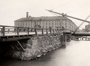
Eldkvarn
19th century gristmill in Stockholm, Sweden
Distance: Approx. 416 meters
Latitude and longitude: 59.3275,18.05472222
Eldkvarn was a grand gristmill in central Stockholm that burned in 1878 — an event which was known as "the fire of the century". It was located where today the Stockholm City Hall stands. The mill was built in 1805 for Abraham Niclas Edelcrantz with a steam engine built by Samuel Owen.
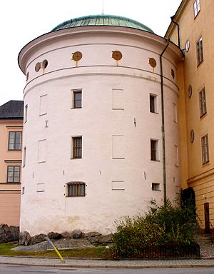
Birger Jarls torn
Defensive tower in Gamla Stan, Sweden (c. 1530)
Distance: Approx. 601 meters
Latitude and longitude: 59.32591667,18.06166667
Birger Jarls torn (Swedish for Birger Jarl's Tower) is a defensive tower on the northwest corner of Riddarholmen, an islet in Gamla Stan, the old town of Stockholm. The building has been named for Birger Jarl who traditionally is attributed as the founder of Stockholm, but it was built several hundred years later and the name is mostly the product of a 17th-century myth. Stockholm literally translates to "Log-Islet", and according to that myth the city was founded where a log drifting ashore from Lake Mälar.

Wrangel Palace
Building in Stockholm, Sweden
Distance: Approx. 621 meters
Latitude and longitude: 59.325,18.0625
Wrangel Palace (Swedish: Wrangelska palatset) is a townhouse mansion on Riddarholmen islet in Gamla Stan, the old town of Stockholm, Sweden.
Svea Court of Appeal
Swedish court of appeal
Distance: Approx. 621 meters
Latitude and longitude: 59.325,18.0625
Svea Court of Appeal (Swedish: Svea hovrätt), located in Stockholm, is one of six appellate courts in the Swedish legal system, as well as the oldest Swedish court currently in use (the Supreme Court being constituted only in 1789, over 150 years later). It is located in the Wrangel Palace, on Riddarholmen islet in Gamla Stan, the old town of Stockholm.

Stadshusbron
Distance: Approx. 472 meters
Latitude and longitude: 59.32777778,18.05583333
Stadshusbron (Swedish: "The City Hall Bridge"), formerly known as Nya Kungsholmsbron ("The New Kungsholm Bridge") is a bridge in central Stockholm, Sweden located just north of the Stockholm City Hall. Stretching over Klara sjö ("Lake Klara"), it connects mainland Norrmalm on the eastern shore to the island Kungsholmen on the western shore. Strong population growth on Kungsholmen caused a first bridge to be built on the location in 1669–1672.

Klara sjö
Distance: Approx. 520 meters
Latitude and longitude: 59.32833333,18.05555556
Klara sjö (Swedish for "Lake Klara") is a canal in central Stockholm, Sweden. Separating the island Kungsholmen from the northern city district Norrmalm, the canal connects Barnhusviken to Riddarfjärden. Together with Barnhusviken, Karlbergssjön, and Karlbergskanalen, it thus forms part of the nameless body of water which separates Kungsholmen from the mainland districts north and east of it, Norrmalm and Vasastaden.

Blue Hall
Banquet hall within Stockholm's city hall
Distance: Approx. 398 meters
Latitude and longitude: 59.32745,18.05417
The Blue Hall (Swedish: Blå hallen) is the main hall of the Stockholm City Hall best known as the banquet hall for the annual Nobel Banquet, and also used for state visits, student balls, jubilees and other large events.
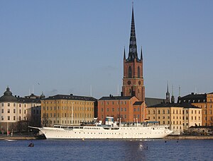
Lady Hutton
Distance: Approx. 625 meters
Latitude and longitude: 59.324,18.0627
Lady Hutton is a former luxury yacht built in 1924 at Friedrich Krupp Germaniawerft in Kiel, Germany. She has now been converted to a hotel and restaurant ship, riding at anchor at the Riddarholmen in Stockholm since 1982. In addition to its size and proximity to the old city, much of the ship’s fame is tied to Barbara Hutton, for whom the ship is named.

Kungsholm Church
Church in Kungsholmen, Sweden
Distance: Approx. 563 meters
Latitude and longitude: 59.3289,18.0486
Kungsholm Church (Swedish: Kungsholms kyrka) or Ulrika Eleonora Church (Swedish: Ulrika Eleonora kyrka) is a church building at Bergsgatan on the island of Kungsholmen in Stockholm, Sweden. Belonging to the Västermalm Parish of the Church of Sweden, the church was inaugurated on 2 December 1688 (Old Style).

City of Stockholm (city municipality)
City municipality in Stockholm County, Sweden
Distance: Approx. 422 meters
Latitude and longitude: 59.3275,18.055
The City of Stockholm (Swedish: Stockholms stad) was a city in Sweden and 1863–1970 a city municipality for Stockholm, subordinate to the Office of the Governor of Stockholm until 1967 and then part of Stockholm County.
Weather in this IP's area
clear sky
18 Celsius
18 Celsius
17 Celsius
19 Celsius
1031 hPa
75 %
1031 hPa
1030 hPa
10000 meters
2.57 m/s
230 degree
06:28:17
18:54:05