Country:
 Netherlands
Region:
City:
Latitude and Longitude:
Time Zone:
Postal Code:
IP information under different IP Channel
ip-api
Country
Region
City
ASN
Time Zone
ISP
Blacklist
Proxy
Latitude
Longitude
Postal
Route
IPinfo
Country
Region
City
ASN
Time Zone
ISP
Blacklist
Proxy
Latitude
Longitude
Postal
Route
MaxMind
Country
Region
City
ASN
Time Zone
ISP
Blacklist
Proxy
Latitude
Longitude
Postal
Route
Luminati
Country
NLRegion
nh
City
amsterdam
ASN
Time Zone
Europe/Amsterdam
ISP
Net Gate Comunicatii Srl
Latitude
Longitude
Postal
db-ip
Country
Region
City
ASN
Time Zone
ISP
Blacklist
Proxy
Latitude
Longitude
Postal
Route
ipdata
Country
Region
City
ASN
Time Zone
ISP
Blacklist
Proxy
Latitude
Longitude
Postal
Route
Popular places and events near this IP address
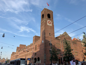
Beurs van Berlage
Building in Amsterdam
Distance: Approx. 125 meters
Latitude and longitude: 52.375,4.89638889
The Beurs van Berlage (literally Berlage's stock market) is a building on the Damrak, in the centre of Amsterdam. It was designed as a commodity exchange by architect Hendrik Petrus Berlage and constructed between 1896 and 1903. It influenced many modernist architects, in particular functionalists and the Amsterdam School.
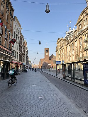
Damrak
Avenue in Amsterdam between Centraal and Dam Square
Distance: Approx. 30 meters
Latitude and longitude: 52.37611111,4.89722222
The Damrak is an avenue and partially filled in canal at the centre of Amsterdam, Netherlands, running between Amsterdam Centraal in the north and Dam Square in the south. It is the main street where people arriving at the station enter the centre of the city. Also, it is one of the two GVB tram routes from the station into the centre, with lines 4, 9, 16, and 25 running down it.

Oude Kerk, Amsterdam
Church building in Amsterdam
Distance: Approx. 170 meters
Latitude and longitude: 52.3744,4.898
The Oude Kerk (English: Old Church) is Amsterdam's oldest building and newest art institute (since 2012). The building was founded about 1213 and consecrated in 1306 by the bishop of Utrecht with Saint Nicolas as its patron saint. After the Reformation in 1578, it became a Calvinist church, which it remains today.

Prostitution Information Center
Resource for visitors to Amsterdam
Distance: Approx. 181 meters
Latitude and longitude: 52.3747543,4.8956064
The Prostitution Information Centre (PIC, Dutch: Prostitutie Informatie Centrum) is located in the heart of Amsterdam in the red light district, near Amsterdam's Old Church. The PIC serves as an educational centre and resource for providing Amsterdam's visitors with information and advice about prostitution. The practice of prostitution in the Netherlands was legalised nationally in October 2000.

Warmoesstraat
Distance: Approx. 60 meters
Latitude and longitude: 52.37548111,4.89805556
Warmoesstraat ('Chard Street') is one of the oldest streets in Amsterdam, running parallel to Damrak from Nieuwebrugsteeg to Dam Square. Its origins are in the 13th century. In the 16th and 17th century it was the shopping street.

Ons' Lieve Heer op Solder
House church and museum in Amsterdam
Distance: Approx. 156 meters
Latitude and longitude: 52.375076,4.899363
Ons' Lieve Heer op Solder (OLHOS; English: Our Lord in the Attic) is a 17th-century canal house, house church, and museum in the city center of Amsterdam, The Netherlands. The Catholic Church was built on the top three floors of the canal house during the 1660s. It is an important example of a "schuilkerk", or "clandestine church" in which Catholics and other religious dissenters from the seventeenth century Dutch Reformed Church, unable to worship in public, held services.

Oudekerksplein
Square in Amsterdam, Netherlands
Distance: Approx. 194 meters
Latitude and longitude: 52.37416667,4.89777778
The Oudekerksplein (English: Old Church's Square) is a square in the centre of Amsterdam. It is named after the 14th-century church Oude Kerk which dominates the square. The Oudekerksplein is wedged between the Warmoesstraat street and Oudezijds Voorburgwal canal.
Burgwallen Oude Zijde
Neighborhood of Amsterdam in North Holland, Netherlands
Distance: Approx. 166 meters
Latitude and longitude: 52.37444444,4.89805556
Burgwallen Oude Zijde is a neighborhood of Amsterdam, Netherlands.
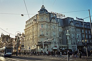
Victoria Hotel, Amsterdam
Hotel in Amsterdam
Distance: Approx. 113 meters
Latitude and longitude: 52.3769,4.8978
The Victoria Hotel is a major hotel in Amsterdam, Netherlands. It is on the corner of the Damrak and Prins Hendrikkade, close to Amsterdam Centraal station. The Victoria Hotel is one of the oldest hotels in The Netherlands.
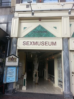
Sexmuseum Amsterdam
Sex museum in Amsterdam, Netherlands
Distance: Approx. 79 meters
Latitude and longitude: 52.3765923,4.8972585
The Sexmuseum or the Temple of Venus (Dutch: Venustempel) is a sex museum located in Amsterdam, Netherlands. The museum was opened in 1985. It had 675,000 visitors in 2015, making it one of the most visited museums in the Netherlands.

Nieuwendijk, Amsterdam
Street in Amsterdam
Distance: Approx. 147 meters
Latitude and longitude: 52.37591389,4.89533056
The Nieuwendijk is a major shopping street in central Amsterdam. There are some 200 shops along the street. The street, which dates to the early medieval history of Amsterdam, counts 98 buildings with rijksmonument status.

The Queen's Head (Amsterdam)
Gay bar in Amsterdam
Distance: Approx. 69 meters
Latitude and longitude: 52.3756272,4.8984045
The Queen's Head is a gay bar located at Zeedijk 20 in the centre of Amsterdam. It opened in 1998 and is known for its drag queen bingo evenings.
Weather in this IP's area
few clouds
21 Celsius
21 Celsius
20 Celsius
22 Celsius
1006 hPa
63 %
1006 hPa
1005 hPa
10000 meters
5.66 m/s
180 degree
20 %
07:03:46
20:12:35