Country:
Region:
City:
Latitude and Longitude:
Time Zone:
Postal Code:
IP information under different IP Channel
ip-api
Country
Region
City
ASN
Time Zone
ISP
Blacklist
Proxy
Latitude
Longitude
Postal
Route
Luminati
Country
Region
an
City
seville
ASN
Time Zone
Europe/Madrid
ISP
Comvive Servidores S.L.
Latitude
Longitude
Postal
IPinfo
Country
Region
City
ASN
Time Zone
ISP
Blacklist
Proxy
Latitude
Longitude
Postal
Route
db-ip
Country
Region
City
ASN
Time Zone
ISP
Blacklist
Proxy
Latitude
Longitude
Postal
Route
ipdata
Country
Region
City
ASN
Time Zone
ISP
Blacklist
Proxy
Latitude
Longitude
Postal
Route
Popular places and events near this IP address

Hispania Baetica
Roman province in the southwest of the Iberian Peninsula
Distance: Approx. 7954 meters
Latitude and longitude: 37.5,-6
Hispania Baetica, often abbreviated Baetica, was one of three Roman provinces created in Hispania (the Iberian Peninsula) on 27 BC. Baetica was bordered to the west by Lusitania, and to the northeast by Tarraconensis. Baetica remained one of the basic divisions of Hispania under the Visigoths. Its territory approximately corresponds to modern Andalusia.

Battle of Ilipa
Scipio Africanus's most brilliant victory in his military career during the Second Punic War
Distance: Approx. 8210 meters
Latitude and longitude: 37.548825,-5.936332
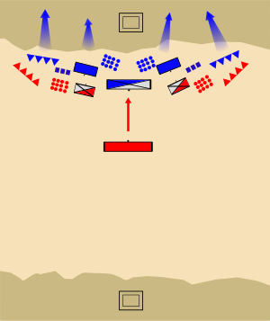
The Battle of Ilipa () was an engagement considered by many as Scipio Africanus’s most brilliant victory in his military career during the Second Punic War in 206 BC. It may have taken place on a plain east of Alcalá del Río, Seville, Spain, near the village of Esquivel, the site of the Carthaginian camp. Though it may not seem to be as original as Hannibal’s tactic at Cannae, Scipio's pre-battle maneuver and his reverse Cannae formation stands as the acme of his tactical ability, in which he forever broke the Carthaginian hold in Iberia, thus denying any further land invasion into Italy and cutting off a rich base for the Barca dynasty both in silver and manpower.

Ilipa
Distance: Approx. 7256 meters
Latitude and longitude: 37.51833333,-5.97833333
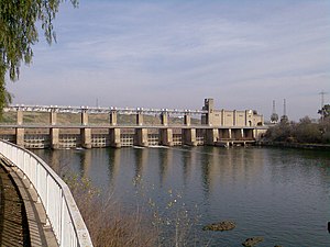
Ilipa (Ancient Greek: Ἴλιπα) or Ilipa Magna was an ancient Iberian city located on the right bank of the River Betis (now known as the Guadalquivir) within one of its meanders. It later became part of the province of Hispania Ulterior and the legal district of Hispalis. Today, its remains can be found in the municipality of Alcalá del Río, in the province of Seville, Spain.

Seville Airport
International airport in Spain
Distance: Approx. 6720 meters
Latitude and longitude: 37.41805556,-5.89888889
Seville Airport (IATA: SVQ, ICAO: LEZL) (Spanish: Aeropuerto de Sevilla) is the sixth busiest inland airport in Spain. It is the main international airport serving Western Andalusia in southern Spain, and neighbouring provinces. The airport has flight connections to 20 destinations in Spain and 57 destinations around the rest of Europe and Northern Africa, and handled 8,071,524 passengers in 2023.

Alcalá del Río
Place in Andalusia, Spain
Distance: Approx. 6361 meters
Latitude and longitude: 37.51666667,-5.96666667
Alcalá del Río is a municipality in Seville, Spain. It had a population of 9,317 in 2005. It has an area of about 83 square kilometers and has a population density of 112.3 people per square kilometer.
La Algaba
Municipality in Seville, Spain
Distance: Approx. 8118 meters
Latitude and longitude: 37.45,-6
La Algaba is a Spanish municipality in the province of Seville, Andalusia, with a population of around 16,000. It is part of the region of La Vega and is located 11 km from the province's capital, Seville. The town dates back to the Byzantine Empire and has many historical artifacts and significant churches.
La Rinconada, Andalusia
City in Seville, Spain
Distance: Approx. 4643 meters
Latitude and longitude: 37.48333333,-5.96666667
La Rinconada is a municipality located in the province of Seville, Andalusia, Spain. According to the 2020 census (INE), the city has a population of 39,062 inhabitants.
Palacio de Congresos railway station
Distance: Approx. 8402 meters
Latitude and longitude: 37.40361111,-5.93638889
Palacio de Congresos (English: Congress Palace) is a station of C-4 line of the suburban trains (Spanish: Cercanías) in the city of Seville, Andalusia. It is located in the intersection of Ciencias and Luis Uruñuela avenues, in the neighborhood of Sevilla Este. Palacio de Congresos is an elevated building situated between the Padre Pío and Santa Justa on the same line.

Monastery of San Jerónimo de Buenavista, Seville
Distance: Approx. 8699 meters
Latitude and longitude: 37.423675,-5.986539
Monastery of San Jerónimo de Buenavista is a former monastery located in the San Jerónimo neighborhood of Seville, Andalusia, Spain. It was founded in 1414 by Father Diego Martínez de Medina. On 27 August 1964, it was declared a Historical-Artistic Monument.

FIBES Conference and Exhibition Centre
Distance: Approx. 8240 meters
Latitude and longitude: 37.40444444,-5.9325
The Conference and Exhibition Centre of Seville (Spanish: Palacio de Congresos y Exposiciones de Sevilla), usually referred to as FIBES or Fibes, is a conference and exhibition centre in Seville, Andalusia, Spain. The centre consists of two buildings, FIBES I and FIBES II, which are connected by a footbridge.

Cemetery of San Fernando
Cemetery in Seville, Andalucia, Spain
Distance: Approx. 8704 meters
Latitude and longitude: 37.41916667,-5.98083333
The Cemetery of San Fernando (Spanish: El Cementerio de San Fernando) is located in the San Jerónimo district, north of the city of Seville, Andalusia, Spain. It was built in 1852, and it is the only municipal cemetery in the city. It has an area of 28 hectares (69 acres) and is considered as one of the most famous cemeteries in Spain.

Birth of a New Man
Monument in Seville
Distance: Approx. 8837 meters
Latitude and longitude: 37.42753,-5.9928
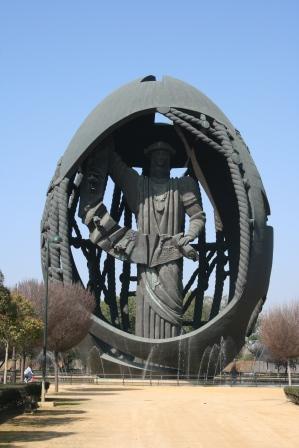
Birth of a New Man (Spanish: Nacimiento de un Hombre Nuevo), popularly known as el huevo de Colón ("the Columbus' egg"), is a monument in Seville, Spain. It is a work by Zurab Tsereteli, consisting of a colossal statue representing Christopher Columbus partially enfolded by an egg-like shell. It was a gift from the city of Moscow to Seville on the occasion of the 500th anniversary of the arrival of Columbus in the Caribbean in 1492.
Weather in this IP's area
clear sky
14 Celsius
14 Celsius
14 Celsius
15 Celsius
1014 hPa
90 %
1014 hPa
1012 hPa
10000 meters
6.69 m/s
70 degree
08:03:40
18:13:12
