Country:
 Portugal
Region:
City:
Latitude and Longitude:
Time Zone:
Postal Code:
IP information under different IP Channel
ip-api
Country
Region
City
ASN
Time Zone
ISP
Blacklist
Proxy
Latitude
Longitude
Postal
Route
IPinfo
Country
Region
City
ASN
Time Zone
ISP
Blacklist
Proxy
Latitude
Longitude
Postal
Route
MaxMind
Country
Region
City
ASN
Time Zone
ISP
Blacklist
Proxy
Latitude
Longitude
Postal
Route
Luminati
Country
PTRegion
16
City
melgaco
ASN
Time Zone
Europe/Lisbon
ISP
Nos Comunicacoes, S.A.
Latitude
Longitude
Postal
db-ip
Country
Region
City
ASN
Time Zone
ISP
Blacklist
Proxy
Latitude
Longitude
Postal
Route
ipdata
Country
Region
City
ASN
Time Zone
ISP
Blacklist
Proxy
Latitude
Longitude
Postal
Route
Popular places and events near this IP address

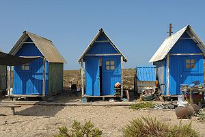
Faro, Portugal
Municipality in Algarve, Portugal
Distance: Approx. 546 meters
Latitude and longitude: 37.01611111,-7.935
Faro ( FAR-oh, Portuguese: [ˈfaɾu] ) is a municipality, the southernmost city and capital of the district of the same name, in the Algarve region of southern Portugal. With an estimated population of 60,995 inhabitants in 2019 (with 39,733 inhabitants in the city proper, making it the biggest city and second most populous municipality in the Algarve (after Loulé) and one of the biggest in Southern Portugal), the municipality covers an area of about 202.57 km2 (78.21 sq mi).
Barreta Island
Island in southern Portugal
Distance: Approx. 5529 meters
Latitude and longitude: 36.97,-7.924
Barreta Island (Portuguese: Ilha da Barretta) is an island in Algarve, Portugal, about 7 kilometres (4.3 mi) long and 50 to 600 metres (160 to 1,970 ft) wide. Barreta is also known as Deserta, Deserted Island or Santa Maria Cape Island. Is one of the more isolated islands in Algarve.
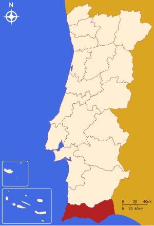
Faro District
District of Portugal
Distance: Approx. 636 meters
Latitude and longitude: 37.015,-7.935
Faro District (Portuguese: Distrito de Faro [ˈfaɾu] ) is the southernmost district of Portugal. The area is the same as that of the Algarve region. The administrative centre, or district capital, is the city of Faro.
University of Algarve
Distance: Approx. 413 meters
Latitude and longitude: 37.02236111,-7.92763889
The University of Algarve (UAlg; Portuguese: Universidade do Algarve), founded in 1979, is a Portuguese public higher education institution located in the southernmost region of mainland Portugal, the Algarve, having its headquarters and two out of its three campuses in Faro (namely the Gambelas and Penha) and another campus in Portimão. It has around 10,000 students, 20 per cent of whom are international, from more than 90 nationalities, with Brazil being the most representative country of origin for those foreign students.

Faro Airport
International airport serving Faro, Portugal
Distance: Approx. 3194 meters
Latitude and longitude: 37.01444444,-7.96583333
Faro International Airport (Portuguese: Aeroporto de Faro, IATA: FAO, ICAO: LPFR), officially Faro - Gago Coutinho International Airport (Aeroporto Internacional de Faro - Gago Coutinho), is located four kilometres (two nautical miles) west of the city of Faro in Portugal. The airport opened in July 1965 being the main gateway to Faro District (the year-round resort region of the Algarve) and southwestern Spain, with nine million passengers using the facility in 2019. Since 2022, it is named after Gago Coutinho, Portuguese geographer, cartographer, naval officer, historian and aviation pioneer.

Martinair Flight 495
1992 aviation accident
Distance: Approx. 3135 meters
Latitude and longitude: 37.01277778,-7.96472222
Martinair Flight 495 was a McDonnell Douglas DC-10 operated by Dutch airline Martinair, that crash-landed in severe weather conditions at Faro Airport, Portugal on 21 December 1992. The aircraft carried 13 crew members and 327 passengers, mainly holidaymakers from the Netherlands. The crash killed 54 passengers and 2 crew members; 106 of the other occupants were badly injured.

Estádio de São Luís
Football stadium in Faro, Portugal
Distance: Approx. 410 meters
Latitude and longitude: 37.02277778,-7.92861111
São Luís Stadium, also known as Estádio Municipal de São Luís, is a multi-use stadium located in Faro, Algarve, Portugal. It serves as the home stadium for Sporting Clube Farense, a football club based in Faro. The stadium was opened in 1923 and has a seating capacity of around 7,000 spectators.
Roman Catholic Diocese of Faro
Roman Catholic diocese in Portugal
Distance: Approx. 782 meters
Latitude and longitude: 37.0133,-7.9348
The Diocese of Faro (Latin: Dioecesis Pharaonensis), also called the Diocese of the Algarve and formerly the Diocese of Silves, is a Latin Church diocese of the Catholic church in Portugal. It is a suffragan of the archdiocese of Évora. The current bishop of Faro is Manuel Neto Quintas.

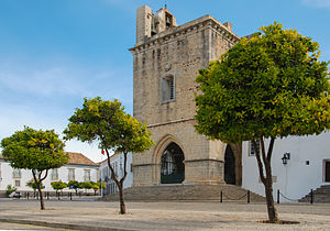
Faro Cathedral
Cathedral in Faro, Portugal
Distance: Approx. 775 meters
Latitude and longitude: 37.01333333,-7.93472222
Faro Cathedral (Portuguese: Sé de Faro) is a Roman Catholic cathedral in Faro, Portugal. The cathedral was consecrated in the name of the Blessed Virgin Mary in the late 13th century by the Archbishop of Braga. It has been the seat of the Diocese of Faro since 1540, replacing Silves Cathedral on the orders of King John III of Portugal.

Capela dos Ossos (Faro)
Ossuary chapel in Faro, Portugal
Distance: Approx. 368 meters
Latitude and longitude: 37.019901,-7.934527
The Capela dos Ossos (transl. Chapel of Bones) is an ossuary chapel in Faro, Portugal, which belongs to the 18th century Carmelite church, Nossa Senhora do Carmo. Above the entrance, there is the following inscription: Pára aqui a considerar que a este estado hás-de chegar which translates to Stop here and consider, that you will reach this state too. The 4 by 6 metre-sized chapel is built of the bones of more than 1,000 Carmelite friars and has been inaugurated in 1816.
Conceição e Estoi
Civil parish in Algarve, Portugal
Distance: Approx. 4614 meters
Latitude and longitude: 37.06,-7.92
Conceição e Estoi is a civil parish in the municipality of Faro, part of the Portuguese Algarve, formed in 2013 from the merger of the former parishes Conceição and Estoi. The population in 2011 was 8,176, in an area of 68.40 km2.

Faro railway station
Railway station in Portugal
Distance: Approx. 827 meters
Latitude and longitude: 37.018508,-7.939677
Faro station (Portuguese: Estação de Faro) is the main railway station in the city of Faro, Portugal, operated by Comboios de Portugal. It opened on 1 July 1889. The line to the north-west is electrified, using overhead catenary.
Weather in this IP's area
clear sky
21 Celsius
20 Celsius
20 Celsius
23 Celsius
1017 hPa
56 %
1017 hPa
1014 hPa
10000 meters
2.57 m/s
270 degree
07:26:20
19:16:43