Country:
 France
Region:
City:
Latitude and Longitude:
Time Zone:
Postal Code:
IP information under different IP Channel
ip-api
Country
Region
City
ASN
Time Zone
ISP
Blacklist
Proxy
Latitude
Longitude
Postal
Route
IPinfo
Country
Region
City
ASN
Time Zone
ISP
Blacklist
Proxy
Latitude
Longitude
Postal
Route
MaxMind
Country
Region
City
ASN
Time Zone
ISP
Blacklist
Proxy
Latitude
Longitude
Postal
Route
Luminati
Country
FRRegion
occ
City
toulouse
ASN
Time Zone
Europe/Paris
ISP
Societe Francaise Du Radiotelephone - SFR SA
Latitude
Longitude
Postal
db-ip
Country
Region
City
ASN
Time Zone
ISP
Blacklist
Proxy
Latitude
Longitude
Postal
Route
ipdata
Country
Region
City
ASN
Time Zone
ISP
Blacklist
Proxy
Latitude
Longitude
Postal
Route
Popular places and events near this IP address

Toulouse
Prefecture and commune in France
Distance: Approx. 89 meters
Latitude and longitude: 43.6045,1.444
Toulouse ( too-LOOZ; French: [tuluz] ; Occitan: Tolosa [tuˈluzɔ]) is the prefecture of the French department of Haute-Garonne and of the larger region of Occitania. The city is on the banks of the River Garonne, 150 kilometres (93 miles) from the Mediterranean Sea, 230 km (143 mi) from the Atlantic Ocean and 680 km (420 mi) from Paris. It is the fourth-largest city in France after Paris, Marseille and Lyon, with 504,078 inhabitants within its municipal boundaries (2021); its metropolitan area has a population of 1.5 million inhabitants (2021).
University of Toulouse
Former French university in Toulouse
Distance: Approx. 99 meters
Latitude and longitude: 43.60444444,1.44388889
The University of Toulouse (French: Université de Toulouse) is a community of universities and establishments (ComUE) based in Toulouse, France. Originally it was established in 1229, making it one of the earliest universities to emerge in Europe. Suppressed during the French Revolution in 1793, it was refounded in 1896 as part of the reorganization of higher education.
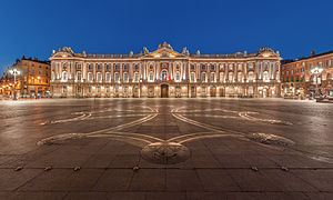
Capitole de Toulouse
Center of municipal administration of Toulouse, France
Distance: Approx. 89 meters
Latitude and longitude: 43.6045,1.444
The Capitole de Toulouse (Occitan: Capitòli de Tolosa; lit. 'Capitol of Toulouse'), commonly known as the Capitole, is the heart of the municipal administration and the city hall of the French city of Toulouse.

Théâtre du Capitole
Opera house in Toulouse, France
Distance: Approx. 72 meters
Latitude and longitude: 43.60416667,1.44444444
The Théâtre du Capitole de Toulouse is an opera house within the main administration buildings, the Capitole, of the city of Toulouse in south-west France. It houses an opera company, ballet company and symphony orchestra, Orchestre national du Capitole de Toulouse. The first performance space, a salle du jeu de spectacle, was created in the building in 1736 by Guillaume Cammas.

Siege of Toulouse (1217–1218)
Distance: Approx. 201 meters
Latitude and longitude: 43.6053,1.4428
Toulouse was besieged from 22 September 1217 to 25 July 1218 during the Albigensian Crusade. It was the third of a series of sieges of the city during the height of Crusader efforts to put down Catharism (and the local Languedocian nobility). It ended in the repulsion of the Crusaders and the death of their leader, Simon IV de Montfort.
Federal University of Toulouse Midi-Pyrénées
Distance: Approx. 99 meters
Latitude and longitude: 43.6044,1.4439
Federal University of Toulouse Midi-Pyrénées (French: Université fédérale de Toulouse Midi-Pyrénées, UFTMP) is the association of universities and higher education institutions (ComUE) for institutions of higher education and research in the French region of Midi-Pyrénées (now called Occitania). On 1 January 2023 it was renamed as the University of Toulouse.
Battle of Toulouse (844)
Battle of the Carolingian Civil War
Distance: Approx. 89 meters
Latitude and longitude: 43.6045,1.444
The Battle of Toulouse in 844 was part of the campaign by Charles the Bald in Aquitaine to force the submission of Pepin II of Aquitaine, the rebellious son of Pepin, the half-brother of Charles. The historical context of this battle is the three-year Carolingian civil war, culminating in the Battle of Fontenay-en-Puisaye in 841. Here Charles and Louis the German defeated their brother Lothair I, who retreated to the south with his army.

Notre-Dame du Taur
Medieval-era Roman Catholic church in Toulouse, France
Distance: Approx. 209 meters
Latitude and longitude: 43.6056,1.44291111
Notre-Dame du Taur is a Roman Catholic church located in Toulouse, France. According to legend, the edifice was built on the exact spot where the body of Saint Saturnin (Sernin), patron saint of Toulouse, became detached from the bull that dragged the martyr to his death. The church stands in the rue du Taur between the Capitole and the Basilica of St.

Hôtel Dumay
Hôtel particulier in Toulouse, France
Distance: Approx. 298 meters
Latitude and longitude: 43.60236,1.44308
The Hôtel Dumay, a historic building in Toulouse, France, is a Renaissance hôtel particulier (palace) of the 16th century. It has been listed as an official historical monument by the French Ministry of Culture since June 21, 1950. The Dumay hotel retains the name of the man who built it at the end of the 16th century, Antoine Dumay, a renowned physician, notably a doctor of Marguerite de Valois, Henri IV's first wife.
Battle of Toulouse (439)
439 battle
Distance: Approx. 89 meters
Latitude and longitude: 43.6045,1.444
The Battle of Toulouse was fought between the Visigoths and the Western Roman Empire in 439. Having previously defeated the Visigoths at Narbonne, the Roman general Litorius led his largely Hunnic army against Toulouse, the capital of the Visigothic Kingdom. During the siege, the Visigothic king Theodoric I attacked the Roman camp and inflicted heavy casualties.
Battle of Toulouse (458)
458 battle
Distance: Approx. 89 meters
Latitude and longitude: 43.6045,1.444
The Battle of Toulouse was fought in the Gothic War between the Visigoths and the Western Roman Empire in 458. The battle was part of a great mid-winter expedition made across the alps by Emperor Majorian, taking a large army from Italy into Gaul with the goal of restoring the region to Roman rule after the disastrous reign of Avitus. Majorian and the Visigothic king Theodoric II fought a battle at Toulouse, in which the Visigoths were defeated.

Saint-Jérôme Church (Toulouse)
Church from 17th century
Distance: Approx. 170 meters
Latitude and longitude: 43.6033,1.4462
The church of the Sanctuaire Saint-Jérôme (former chapel of the Pénitents bleus), rue du Lieutenant-Colonel-Pélissier (former rue des Pénitents bleus), is a church built by the Compagnie royale des Pénitents bleus de Toulouse. It was built in the 17th century by architect Pierre Levesville under Louis XIII, the first French king to join the brotherhood. The Pénitents bleus called on Toulouse's finest artists to decorate their chapel, which didn't suffer too much during the French Revolution.
Weather in this IP's area
clear sky
22 Celsius
22 Celsius
22 Celsius
23 Celsius
991 hPa
68 %
991 hPa
973 hPa
10000 meters
4.63 m/s
140 degree
08:01:14
19:21:16