Country:
 Romania
Region:
City:
Latitude and Longitude:
Time Zone:
Postal Code:
IP information under different IP Channel
ip-api
Country
Region
City
ASN
Time Zone
ISP
Blacklist
Proxy
Latitude
Longitude
Postal
Route
IPinfo
Country
Region
City
ASN
Time Zone
ISP
Blacklist
Proxy
Latitude
Longitude
Postal
Route
MaxMind
Country
Region
City
ASN
Time Zone
ISP
Blacklist
Proxy
Latitude
Longitude
Postal
Route
Luminati
Country
RORegion
b
City
bucharest
ASN
Time Zone
Europe/Bucharest
ISP
Orange Romania S.A.
Latitude
Longitude
Postal
db-ip
Country
Region
City
ASN
Time Zone
ISP
Blacklist
Proxy
Latitude
Longitude
Postal
Route
ipdata
Country
Region
City
ASN
Time Zone
ISP
Blacklist
Proxy
Latitude
Longitude
Postal
Route
Popular places and events near this IP address
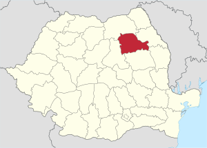
Neamț County
County of Romania
Distance: Approx. 5992 meters
Latitude and longitude: 46.97,26.4
Neamț County (Romanian pronunciation: [ne̯amt͡s] ) is a county (județ) of Romania, in the historic region of Moldavia, with the county seat at Piatra Neamț. The county takes its name from the Neamț River.

Piatra Neamț
Municipality in Neamț, Romania
Distance: Approx. 835 meters
Latitude and longitude: 46.9275,26.37083333
Piatra Neamț (Romanian: [ˈpjatra ˈne̯amts]; ‹See Tfd›German: Kreuzburg an der Bistritz; Hungarian: Karácsonkő) is the capital city of Neamț County, in the historical region of Western Moldavia, in northeastern Romania. Because of its very privileged location in the Eastern Carpathian mountains, it is considered one of the most picturesque cities in Romania. The Nord-Est Regional Development Agency is located in Piatra Neamț.

Teatrul Tineretului
Distance: Approx. 1375 meters
Latitude and longitude: 46.9322,26.368
Teatrul Tineretului (Youth's Theatre) is a cultural institution and a landmark of the city of Piatra Neamț, Romania. It is one of the most well-known theaters in Romania since many important Romanian actors began their career here. For over 50 years, Teatrul Tineretului has been a major cultural institution in Romania.

Archaeology Museum Piatra Neamț
Archeology museum in Piatra Neamț, Romania
Distance: Approx. 894 meters
Latitude and longitude: 46.92798,26.36946
The History & Archaeology Museum in Piatra Neamț, Romania, was founded at the beginning of the 20th century by Constantin Matasă, a minister and amateur archaeologist. The museum houses the most important collection of Cucuteni culture artifacts and it is the home of the Cucuteni Research Centre. The famous piece, Hora de la Frumuşica ("The Frumuşica Dance," the symbol of Cucuteni culture), can be found on the museum website.

Petru Rareș National College (Piatra Neamț)
Distance: Approx. 1485 meters
Latitude and longitude: 46.93332,26.3698
The Petru Rareș National College (Colegiul Național Petru Rareș) is the oldest high school in Piatra Neamț, Romania, located at 5 Ștefan cel Mare Street. At the 2024 evaluation of Romanian secondary schools, it came in 15th place, with a score of 9.41/10. The school building dates to 1890–1892, and is classified as a historic monument by Romania's Ministry of Culture and Religious Affairs.

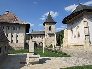
Bistrița Monastery
Distance: Approx. 7489 meters
Latitude and longitude: 46.95778,26.28927
The Bistrița Monastery (Romanian: Mănăstirea Bistrița, pronounced [ˈbistrit͡sa] ) is a Romanian Orthodox monastery located 8 km west of Piatra Neamț. It was dedicated in 1402, having as original ctitor the Moldavian Voivode Alexandru cel Bun whose remains are buried here. The church is historically and archaeologically valuable.
Cuejdiu
River in Neamț County, Romania
Distance: Approx. 474 meters
Latitude and longitude: 46.92361111,26.3675
The Cuejdiu is a left tributary of the river Bistrița in Romania. It discharges into the Bistrița in Piatra Neamț. Its length is 24 km (15 mi) and its basin size is 98 km2 (38 sq mi).
Doamna (Bistrița)
River in Neamț, Romania
Distance: Approx. 3492 meters
Latitude and longitude: 46.93194444,26.32833333
The Doamna is a right tributary of the river Bistrița in Romania. It flows into the Bâtca Doamnei Reservoir near Piatra Neamț. Its length is 8 km (5.0 mi) and its basin size is 22 km2 (8.5 sq mi).
Alexandru cel Bun, Neamț
Commune in Neamț, Romania
Distance: Approx. 7822 meters
Latitude and longitude: 46.94194444,26.27305556
Alexandru cel Bun is a commune in Neamț County, Western Moldavia, Romania. It was called Viișoara until 2002, when its name was changed. The commune is composed of seven villages: Agârcia, Bisericani, Bistrița, Scăricica, Vaduri, Vădurele, and Viișoara (the commune center).

Nativity of St. John the Baptist Church, Piatra Neamț
Orthodox church in Neamț, Romania
Distance: Approx. 1446 meters
Latitude and longitude: 46.932917,26.36884
The Nativity of St. John the Baptist Church (Romanian: Biserica Nașterea Sf. Ioan Botezătorul), located at 2 Piața Libertății, Piatra Neamț, Romania, is a Romanian Orthodox church.
Cozla Fossil Site
Distance: Approx. 2718 meters
Latitude and longitude: 46.9442,26.3661
The Cozla Fossil Site is located near the town of Piatra Neamț in Romania. The limestones exposed at this site are part of the Cozla Formation.

Piatra Neamț hospital fire
2020 fire in Piatra Neamț, Romania
Distance: Approx. 1002 meters
Latitude and longitude: 46.92875,26.37391667
On 14 November 2020, around 18:30 EET, a fire broke out in the COVID-19 ward of the Piatra Neamț Emergency Hospital in Piatra Neamț, Romania. The fire killed ten people and injured another four, including two doctors. All the deceased people were patients receiving treatment for COVID-19.
Weather in this IP's area
moderate rain
18 Celsius
18 Celsius
18 Celsius
18 Celsius
1011 hPa
83 %
1011 hPa
975 hPa
10000 meters
1.32 m/s
1.56 m/s
300 degree
98 %
07:18:45
18:46:44