92.62.70.132 - IP Lookup: Free IP Address Lookup, Postal Code Lookup, IP Location Lookup, IP ASN, Public IP
Country:
Region:
City:
Location:
Time Zone:
Postal Code:
ISP:
ASN:
language:
User-Agent:
Proxy IP:
Blacklist:
IP information under different IP Channel
ip-api
Country
Region
City
ASN
Time Zone
ISP
Blacklist
Proxy
Latitude
Longitude
Postal
Route
db-ip
Country
Region
City
ASN
Time Zone
ISP
Blacklist
Proxy
Latitude
Longitude
Postal
Route
IPinfo
Country
Region
City
ASN
Time Zone
ISP
Blacklist
Proxy
Latitude
Longitude
Postal
Route
IP2Location
92.62.70.132Country
Region
osh shaary
City
osh
Time Zone
Asia/Bishkek
ISP
Language
User-Agent
Latitude
Longitude
Postal
ipdata
Country
Region
City
ASN
Time Zone
ISP
Blacklist
Proxy
Latitude
Longitude
Postal
Route
Popular places and events near this IP address

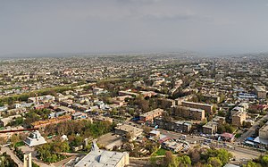
Osh
City in southern Kyrgyzstan
Distance: Approx. 849 meters
Latitude and longitude: 40.53,72.8
Osh (, Kyrgyz: [ɔɕ], Russian: [oʂ]) is the second-largest city in Kyrgyzstan, located in the Fergana Valley in the south of the country. It is often referred to as the "capital of the south". It is the oldest city in the country (estimated by UNESCO to be more than 3,000 years old) and has served as the administrative center of Osh Region since 1939.

Sulayman Mountain
UNESCO World Heritage Site in Kyrgyzstan
Distance: Approx. 640 meters
Latitude and longitude: 40.53111111,72.78277778
The Sulayman Mountain (Kyrgyz: Сулайман-Тоо, also known as Sulaiman-Too, Sulayman Rock, or The Throne of Sulayman) is the only World Heritage Site located entirely in the country of Kyrgyzstan. It is located in the city of Osh and was once a major place of pre-Muslim pilgrimage. The rock rises abruptly from the surrounding plains of the Fergana Valley and is a popular place among locals and visitors, with a splendid view.
Aga Khan School, Osh
Private school
Distance: Approx. 2293 meters
Latitude and longitude: 40.512781,72.806009
The Aga Khan School, Osh, in the Kyrgyz Republic, was established in September 2002. On October 30, 2002, the Governor of Osh Oblast, Naken Kasiev, inaugurated the School in the presence of His Highness the Aga Khan. The school is part of the Aga Khan Education Services (AKES).

Osh State University
Public university in Osh, Kyrgyzstan
Distance: Approx. 493 meters
Latitude and longitude: 40.53166667,72.795
The Osh State University (Kyrgyz: Ош мамлекеттик университети, Russian: Ошский государственный университет, Uzbek: Osh davlat universiteti) is a public university in Osh, the second largest city in Kyrgyzstan. The university was originally established by the Kirghiz SSR in 1939 as a teacher training institute and was upgraded to a comprehensive pedagogical institute in 1951. The institute was awarded full university status in 1992 in the immediate aftermath of the dissolution of the Soviet Union.

Suyumbayev Stadion
Sporting venue in Kazakhstan
Distance: Approx. 1588 meters
Latitude and longitude: 40.52055556,72.80472222
Suyumbayev Stadion is a multi-use stadium in Osh, Kyrgyzstan. It is currently used mostly for football matches and serves as the home stadium for Alay Osh and Ak-Bura Osh of the Kyrgyzstan League. The stadium has a capacity of 12,000 people.
Dyykan-Kyshtak
Place in Osh Region, Kyrgyzstan
Distance: Approx. 2319 meters
Latitude and longitude: 40.51,72.78
Dyykan-Kyshtak (Kyrgyz: Дыйкан-Кыштак) is a village in Osh Region of Kyrgyzstan. It is part of the Kara-Suu District. Its population was 13,406 in 2021.
Kyzyl-Kyshtak
Place in Osh, Kyrgyzstan
Distance: Approx. 2159 meters
Latitude and longitude: 40.54444444,72.77388889
Kyzyl-Kyshtak is a village in Osh Region of Kyrgyzstan. It is part of the Kara-Suu District. Its population was 11,971 in 2021.
1990 Osh clashes
Kyrgyz–Uzbek ethnic conflict in the Kirghiz SSR
Distance: Approx. 849 meters
Latitude and longitude: 40.53,72.8
1990 Osh riots (Kyrgyz: Ош окуясы; Uzbek: Oʻsh voqeasi, Ўш воқеаси; Russian: Ошская резня) were an ethnic conflict between Kyrgyz and Uzbeks that took place in June 1990 in the cities of Osh and Uzgen, part of the Kirghiz SSR. The immediate cause of the riots was a dispute between an Uzbek nationalist group Adolat and a Kyrgyz nationalist group Osh Aymaghi over the land of a former collective farm. While official estimates of the death toll range from over 300 to more than 600, unofficial figures range up to more than 1,000. The riots have been seen as a forerunner to the 2010 ethnic clashes in the same region.

2010 South Kyrgyzstan ethnic clashes
Kyrgyz–Uzbek clashes after President Kurmanbek Bakiyev's ouster
Distance: Approx. 849 meters
Latitude and longitude: 40.53,72.8
The 2010 South Kyrgyzstan ethnic clashes (Kyrgyz: Ош коогалаңы; Uzbek: Qirgʻiziston janubidagi tartibsizliklar, Қирғизистон жанубидаги тартибсизликлар; Russian: Беспорядки на юге Киргизии) were clashes between ethnic Kyrgyz and Uzbeks in southern Kyrgyzstan, primarily in the cities of Osh and Jalal-Abad, in the aftermath of the ouster of former President Kurmanbek Bakiyev on 7 April. It is part of the larger Kyrgyz Revolution of 2010. Violence that started between Kyrgyz and Uzbeks on 19 May in Jalal-Abad escalated on 10 June in Osh.

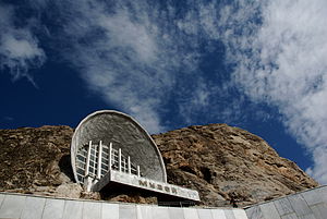
National Historical and Archaeological Museum Complex Sulayman
Historical and archeological museum in Osh, Kyrgyzstan
Distance: Approx. 542 meters
Latitude and longitude: 40.5285,72.7837
The National Historical and Archaeological Museum Complex Sulayman (Russian: Национальный Историко-археологический музейный комплекс «Сулайман-Тоо») is a museum in Osh, Kyrgyzstan. It was established in 1949 as Osh Regional Museum. The present museum building was completed during the Soviet era in 1978 to celebrate the 3,000th anniversary of the city of Osh.
Jiydalik
Place in Osh, Kyrgyzstan
Distance: Approx. 3842 meters
Latitude and longitude: 40.56388889,72.79166667
Jiydalik (Kyrgyz: Жийдалик) is a village in Osh Region of Kyrgyzstan. It is part of the Kara-Suu District. Its population was 5,422 in 2021.
Tashtak
Place in Osh, Kyrgyzstan
Distance: Approx. 2827 meters
Latitude and longitude: 40.53611111,72.82222222
Tashtak (Kyrgyz: Таштак) is a village in Osh Region of Kyrgyzstan. It is part of the Kara-Suu District. Its population was 11,869 in 2021.
Weather in this IP's area
clear sky
-10 Celsius
-15 Celsius
-10 Celsius
-10 Celsius
1033 hPa
73 %
1033 hPa
902 hPa
8000 meters
3 m/s
170 degree