Country:
Region:
City:
Latitude and Longitude:
Time Zone:
Postal Code:
IP information under different IP Channel
ip-api
Country
Region
City
ASN
Time Zone
ISP
Blacklist
Proxy
Latitude
Longitude
Postal
Route
Luminati
Country
ASN
Time Zone
Europe/Lisbon
ISP
Servicos De Comunicacoes E Multimedia S.A.
Latitude
Longitude
Postal
IPinfo
Country
Region
City
ASN
Time Zone
ISP
Blacklist
Proxy
Latitude
Longitude
Postal
Route
db-ip
Country
Region
City
ASN
Time Zone
ISP
Blacklist
Proxy
Latitude
Longitude
Postal
Route
ipdata
Country
Region
City
ASN
Time Zone
ISP
Blacklist
Proxy
Latitude
Longitude
Postal
Route
Popular places and events near this IP address

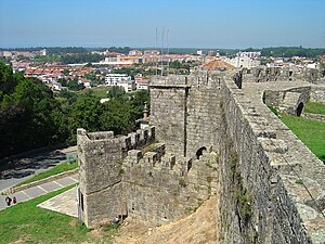
Santa Maria da Feira
Municipality in Norte, Portugal
Distance: Approx. 2869 meters
Latitude and longitude: 40.93333333,-8.53333333
Santa Maria da Feira (European Portuguese pronunciation: [ˈsɐ̃tɐ mɐˈɾi.ɐ ðɐ ˈfɐjɾɐ] ) is a city and a municipality in Aveiro District in Portugal, 23 km from central Porto. The population in 2011 was 139,309, in an area of 215.88 km².
Paços de Brandão
Civil parish in Norte, Portugal
Distance: Approx. 3871 meters
Latitude and longitude: 40.974,-8.59
Paços de Brandão (Portuguese pronunciation: [ˈpasuʒ ðɨ βɾɐ̃ˈdɐ̃w]) is a Portuguese parish in the municipality of Santa Maria da Feira, and Aveiro District. The population in 2011 was 4,867, in an area of 3.56 km2. It is 22 km from Porto, and is part of the Porto Metropolitan Area.
São João de Ver
Civil parish in Norte, Portugal
Distance: Approx. 145 meters
Latitude and longitude: 40.954,-8.551
São João de Ver is a Portuguese parish, located in the municipality of Santa Maria da Feira. The population in 2011 was 10,579, in an area of 15.37 km2.
Santa Maria de Lamas
Civil parish in Norte, Portugal
Distance: Approx. 3493 meters
Latitude and longitude: 40.982,-8.573
Santa Maria de Lamas (Portuguese meaning Saint Mary of Lamas) is a Portuguese civil parish located in the municipality of Santa Maria da Feira, in the district of Aveiro, in the Entre Douro e Vouga Subregion. It is located between the Douro and Vouga rivers and is part of the Porto Metropolitan Area. The population in 2011 was 5,073, in an area of 3.75 km2.

Estádio Marcolino de Castro
Stadium in Santa Maria da Feira, Portugal
Distance: Approx. 3217 meters
Latitude and longitude: 40.92668889,-8.54581389
Estadio Marcolino de Castro is a multi-use stadium in Santa Maria da Feira, Portugal. It is currently used mostly for football matches and is the home of Segunda Liga club CD Feirense. The stadium is able to hold 5,401 people.
Feira (Santa Maria da Feira)
Civil parish in Norte, Portugal
Distance: Approx. 2817 meters
Latitude and longitude: 40.93,-8.552
Feira is a former civil parish in the municipality of Santa Maria da Feira, Portugal. In 2013, the parish merged into the new parish Santa Maria da Feira, Travanca, Sanfins e Espargo. Covering the historic city centre, it is the seat of the Santa Maria da Feira Municipality.
Rio Meão
Civil parish in Norte, Portugal
Distance: Approx. 2526 meters
Latitude and longitude: 40.958,-8.581
Rio Meão is a Portuguese parish, located in the municipality of Santa Maria da Feira. The population in 2011 was 4,931, in an area of 6.68 km2.
Lourosa (Santa Maria da Feira)
Civil parish in Norte, Portugal
Distance: Approx. 3666 meters
Latitude and longitude: 40.988,-8.546
Lourosa (Portuguese pronunciation: [loˈɾɔzɐ]) is a Portuguese civil parish (Pt.freguesia) and a city (Pt.cidade), located in the municipality of Santa Maria da Feira. The population in 2011 was 8,636, in an area of 5.77 km2. Lourosa obtained city status in 2001.
Sanfins (Santa Maria da Feira)
Civil parish in Norte, Portugal
Distance: Approx. 3752 meters
Latitude and longitude: 40.928,-8.525
Sanfins is a former civil parish in the municipality of Santa Maria da Feira, Portugal. In 2013, the parish merged into the new parish Santa Maria da Feira, Travanca, Sanfins e Espargo. It has a population of 1,970 inhabitants and a total area of 3.70 km2.
Residence of Portela
Residence in Santa Maria da Feira, Portugal
Distance: Approx. 3760 meters
Latitude and longitude: 40.97047222,-8.59113889
The Residence of Portela (Portuguese: Casa da Portela) is a 17th-century country house located in the civil parish of Paços de Brandão, in the municipality of Santa Maria da Feira, in the Portuguese Centro district of Aveiro. It was classified as a monument in 1982.
Instituto Superior de Paços de Brandão
Distance: Approx. 3701 meters
Latitude and longitude: 40.9756869,-8.5859507
The Paços de Brandão Senior Institute (Portuguese: Instituto Superior de Paços de Brandão), (abbreviated as ISPAB) is an institution in the civil parish of Paços de Brandão, the municipality of Santa Maria da Feira, in the Portuguese district of Aveiro.
Santa Maria da Feira, Travanca, Sanfins e Espargo
Civil parish in Norte, Portugal
Distance: Approx. 3317 meters
Latitude and longitude: 40.926,-8.544
Santa Maria da Feira, Travanca, Sanfins e Espargo is a civil parish in the municipality of Santa Maria da Feira, Portugal. It was formed in 2013 by the merger of the former parishes Feira, Travanca, Sanfins and Espargo. The population in 2011 was 18,194, in an area of 23.36 km2.
Weather in this IP's area
scattered clouds
15 Celsius
15 Celsius
13 Celsius
15 Celsius
1017 hPa
71 %
1017 hPa
996 hPa
10000 meters
2.38 m/s
2.63 m/s
85 degree
25 %
07:24:26
17:14:19