92.118.30.230 - IP Lookup: Free IP Address Lookup, Postal Code Lookup, IP Location Lookup, IP ASN, Public IP
Country:
Region:
City:
Location:
Time Zone:
Postal Code:
ISP:
ASN:
language:
User-Agent:
Proxy IP:
Blacklist:
IP information under different IP Channel
ip-api
Country
Region
City
ASN
Time Zone
ISP
Blacklist
Proxy
Latitude
Longitude
Postal
Route
db-ip
Country
Region
City
ASN
Time Zone
ISP
Blacklist
Proxy
Latitude
Longitude
Postal
Route
IPinfo
Country
Region
City
ASN
Time Zone
ISP
Blacklist
Proxy
Latitude
Longitude
Postal
Route
IP2Location
92.118.30.230Country
Region
england
City
chalk farm
Time Zone
Europe/London
ISP
Language
User-Agent
Latitude
Longitude
Postal
ipdata
Country
Region
City
ASN
Time Zone
ISP
Blacklist
Proxy
Latitude
Longitude
Postal
Route
Popular places and events near this IP address

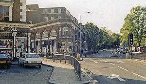
Chalk Farm
Human settlement in England
Distance: Approx. 177 meters
Latitude and longitude: 51.544,-0.152
Chalk Farm is a small urban district of north west London, lying immediately north of Camden Town, in the London Borough of Camden.

Roundhouse (venue)
Performing arts venue in London, England
Distance: Approx. 139 meters
Latitude and longitude: 51.5432,-0.1519
The Roundhouse is a performing arts and concert venue at the Grade II* listed former railway engine shed in Chalk Farm, London, England. The building was erected in 1846–1847 by the London & North Western Railway as a roundhouse, a circular building containing a railway turntable, but was used for that purpose for only about a decade. After being used as a warehouse for a number of years, the building fell into disuse just before World War II. It was first made a listed building in 1954.

Chalk Farm tube station
London Underground station
Distance: Approx. 266 meters
Latitude and longitude: 51.54416667,-0.15333333
Chalk Farm is a London Underground station near Camden Town in the London Borough of Camden. It is on the Edgware branch of the Northern line between Belsize Park and Camden Town stations. For ticketing purposes, Chalk Farm falls in Travelcard Zone 2.
The Barfly
Distance: Approx. 51 meters
Latitude and longitude: 51.54305556,-0.14916667
The Barfly was a chain of live music venues in the United Kingdom originally started by Nick Moore, Jeremy Ledlin and Be Rozzo on Valentine's Day 1997. Club nights and events tended to feature rock, alternative and independent music. The flagship venue was based in Camden Town, London, England.

Chalk Farm Road
Street in Camden Town, London
Distance: Approx. 68 meters
Latitude and longitude: 51.54291,-0.14897
Chalk Farm Road is a street in the Camden Town area of London. There is a widespread misapprehension that the road that runs through Camden Market is part of Camden High Street, but it is actually Chalk Farm Road. Camden Market is a major centre for the retailing of street fashions and other goods targeted at teenagers and young adults, and Chalk Farm Road has an alternative culture atmosphere.

Camden Catacombs
System of underground passages in London
Distance: Approx. 307 meters
Latitude and longitude: 51.54166667,-0.14611111
The Camden Catacombs are a system of underground passages in Camden Town in north London underneath part of the Camden markets, constructed in the 19th century, and as of 2012 owned by Network Rail. They are not true catacombs as they were never used as repositories for dead bodies, instead being an underground area originally used as stables for horses and pit ponies working on the railways. The catacombs also included an underground pool for canal boats operating on the nearby Regent's Canal.

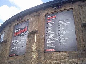
Apple Music Festival
Former concert series held by Apple, Inc.
Distance: Approx. 139 meters
Latitude and longitude: 51.5432,-0.1519
The Apple Music Festival (formerly known as the iTunes Festival) was a concert series held by Apple, Inc. and inaugurated in 2007. Free tickets were given to Apple Music, iTunes and DICE users who lived in the United Kingdom, through localized prize draws.
Camden motive power depot
Distance: Approx. 243 meters
Latitude and longitude: 51.54185,-0.15277
Camden Motive Power Depot was a railway motive power depot, close to Chalk Farm, Camden in London, England from 1837 until 1966, servicing express passenger locomotives using Euston Railway Station. It was closed following the electrification of the West Coast Main Line and largely demolished. However, part of the original facility has been preserved as The Roundhouse centre for the performing arts.

Gilgamesh (restaurant)
Defunct restaurant in London, United Kingdom
Distance: Approx. 161 meters
Latitude and longitude: 51.54222222,-0.14805556
Gilgamesh Restaurant Bar & Lounge was a restaurant and bar in Stables Market, Camden, London, from 2006 to 2018. Despite its Mesopotamian name and theme, the restaurant typically served South East Asian, Chinese and Japanese-inspired eclectic cuisine. Opened in June 2006, the restaurant was inspired by the Sumerian king Gilgamesh.

Statue of Amy Winehouse
Statue in Camden Town, London
Distance: Approx. 165 meters
Latitude and longitude: 51.5424,-0.1478
A bronze statue of the British singer Amy Winehouse is located at the Stables Market in Camden Town, in north London. Sculpted by Scott Eaton, it was unveiled in 2014, three years after the singer's death.
Camden Carriage Servicing Depot
Railway maintenance depot in Greater London, England
Distance: Approx. 301 meters
Latitude and longitude: 51.5422,-0.154
Camden Carriage Servicing Depot is a stabling point located in Camden, Greater London, England. The depot is near what used to be Camden Road station, but it closed down in 1916.

Gloucester Avenue
Street in London, England
Distance: Approx. 300 meters
Latitude and longitude: 51.5407,-0.15187
Gloucester Avenue is a street in the Primrose Hill area of London, England. Located in the London Borough of Camden, it is a residential road featuring many nineteenth century properties including several pubs as well as the neo-Georgian Cecil Sharp House. For much of its route it runs adjacent to the West Coast Main Line out of Euston Station.
Weather in this IP's area
clear sky
9 Celsius
7 Celsius
8 Celsius
10 Celsius
1000 hPa
63 %
1000 hPa
996 hPa
10000 meters
4.63 m/s
240 degree
