Country:
 Russian Federation
Region:
City:
Latitude and Longitude:
Time Zone:
Postal Code:
IP information under different IP Channel
ip-api
Country
Region
City
ASN
Time Zone
ISP
Blacklist
Proxy
Latitude
Longitude
Postal
Route
IPinfo
Country
Region
City
ASN
Time Zone
ISP
Blacklist
Proxy
Latitude
Longitude
Postal
Route
MaxMind
Country
Region
City
ASN
Time Zone
ISP
Blacklist
Proxy
Latitude
Longitude
Postal
Route
Luminati
Country
RUASN
Time Zone
Europe/Moscow
ISP
LLC Multinet-Lugan
Latitude
Longitude
Postal
db-ip
Country
Region
City
ASN
Time Zone
ISP
Blacklist
Proxy
Latitude
Longitude
Postal
Route
ipdata
Country
Region
City
ASN
Time Zone
ISP
Blacklist
Proxy
Latitude
Longitude
Postal
Route
Popular places and events near this IP address

Bakhchysarai
City in Crimea, Ukraine
Distance: Approx. 746 meters
Latitude and longitude: 44.75277778,33.86083333
Bakhchysarai (Ukrainian: Бахчисарай; Crimean Tatar: Bağçasaray, Багъчасарай; Russian: Бахчисарай, romanized: Bakhchisaray; Turkish: Bahçesaray) is a city in the Autonomous Republic of Crimea, Ukraine. It is the administrative center of the Bakhchysarai Raion (district), as well as the former capital of the Crimean Khanate. Its main landmark is Hansaray, the only extant palace of the Crimean Khans, currently open to tourists as a museum.

Bakhchysarai Raion
Raion in Crimea, Ukraine
Distance: Approx. 3067 meters
Latitude and longitude: 44.75,33.9
Bakhchysarai Raion (Russian: Бахчисарайский район; Ukrainian: Бахчисарайський район; Crimean Tatar: Bağçasaray rayonı) is one of the 25 regions of Crimea, an internationally recognized territory of Ukraine occupied and annexed by Russia in 2014. Population: 90,911 (2014 Census). The Bakhchysarai Raion is situated in the southwestern part of the peninsula.

Bakhchysarai Palace
Former residence of the Crimean Khans
Distance: Approx. 1635 meters
Latitude and longitude: 44.74867222,33.88196111
The Khan's Palace (Crimean Tatar: Hansaray; Turkish: Han Sarayı) or Hansaray is located in the town of Bakhchysarai, Crimea. It was built in the 16th century and became home to a succession of Crimean Khans. The walled enclosure contains a mosque, a harem, a cemetery, living quarters and gardens.

Crimean People's Republic
1917–1918 self-declared state in Crimea
Distance: Approx. 749 meters
Latitude and longitude: 44.7528,33.8608
The Crimean People's Republic (Crimean Tatar: Qırım Halq Cumhuriyeti; Ukrainian: Кримська народна республіка, romanized: Kryms'ka narodna respublika; Russian: Крымская народная республика, romanized: Krymskaya narodnaya respublika) or Crimean Democratic Republic was a self-declared state that existed from December 1917 to January 1918 in the Crimean Peninsula. The Republic was one of many short-lived states that declared independence following the 1917 Russian Revolution caused the collapse of the Russian Empire.
Eski Yurt
Former settlement, historical quarter of Bakhchysarai, Crimea
Distance: Approx. 1157 meters
Latitude and longitude: 44.74888889,33.8475
Eski Yurt (Crimean Tatar: Eski Yurt, Ukrainian: Ескі-Юрт, Russian: Эски-Юрт) is a historical settlement in South West Crimea, presently a historical quarter in the western part of Bakhchysarai. Its name derives from the Crimean Tatar language terms for "old settlement" or "old headquarter" and "felt tent".

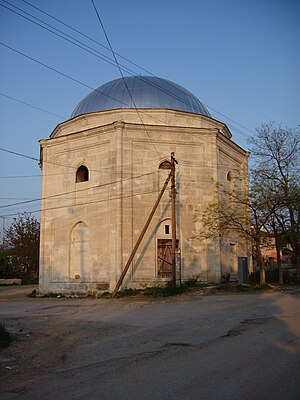
Tahtali-Jami Mosque
Sunni mosque in Bakhchisaray, Crimea
Distance: Approx. 1996 meters
Latitude and longitude: 44.74849,33.88662
The Tahtali-Jami Mosque (Crimean Tatar: Tahtalı Cami, Ukrainian: Тахтали Джамі, Russian: Тахталы-Джами, Turkish: Tahtalı Cami) is located in Bakhchysarai, Crimea.

Big Khan Mosque
Sunni mosque in Bakhchisaray, Crimea
Distance: Approx. 1635 meters
Latitude and longitude: 44.74867222,33.88196111
The Big Khan Mosque (Crimean Tatar: Büyük Han Cami, Ukrainian: Велика ханська мечеть, Russian: Большая ханская мечеть, Turkish: Büyük Han Camii) is located in Bakhchisaray, Crimea, and is part of the Bakhchisaray Palace. It is one of the largest mosques in the Crimea and one of the first buildings of the Khan's palace. The mosque was built in 1532 by Sahib I Giray and bore his name in the 17th century.
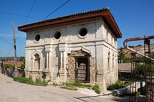
Ismi Khan Jami Mosque
Former mosque in Bakhchisaray, Crimea
Distance: Approx. 714 meters
Latitude and longitude: 44.75102778,33.86738889
Ismi Khan Jami Mosque (Crimean Tatar: İsmi Han Cami) is a ruined mosque of the 17–18th centuries in Bakhchysarai, Crimea. The decor felt European influences (the Baroque or classicism). It was built by an unknown Khan of the Crimean Khanate.

Zincirli Madrasa
Distance: Approx. 3656 meters
Latitude and longitude: 44.74777778,33.90777778
Zincirli Madrasa (Ukrainian: Зинджирли-медресе, Медресе Ланцюгів, Crimean Tatar: Zıncırlı medrese) is a madrasa, built of stone by Meñli I Giray in 1500 near Bakhchysarai, Crimea.

Molla-Mustafa Jami Mosque
Mosque in Bakhchisaray, Crimea
Distance: Approx. 708 meters
Latitude and longitude: 44.75186,33.86541
Molla-Mustafa Jami Mosque is located in Bakhchysarai, Crimea, built approx. in the 18th century by a Khan of the Crimean Khanate. The mosque is mentioned in documents of the Taurida Governorate from 1890, concerning the state of its roof in 1888.

Orta Cami Mosque
Sunni mosque in Bakhchisaray, Crimea
Distance: Approx. 1300 meters
Latitude and longitude: 44.74981944,33.87718333
Orta Cami Mosque (Crimean Tatar: Orta Cami, Ukrainian: Мечеть Орта-Джамі, Russian: Мечеть Орта-Джами, Turkish: Orta Camii) is one of the oldest mosques in Crimea. It is situated on the modern day Lenina Street in the old town of Bakhchysarai. It used to be the main Friday prayer mosque in the capital of Crimean Khanate.

Ukraine's 10th electoral district
Ukrainian electoral district
Distance: Approx. 746 meters
Latitude and longitude: 44.75277778,33.86083333
Ukraine's 10th electoral district is a Verkhovna Rada constituency in the Autonomous Republic of Crimea. Established in its current form in 2012, it contains the city of Bakhchysarai, as well as Bakhchysarai Raion and parts of Simferopol Raion. The constituency was home to 159,391 registered voters in 2012, and has 130 voting stations.
Weather in this IP's area
light rain
22 Celsius
21 Celsius
22 Celsius
22 Celsius
1009 hPa
55 %
1009 hPa
983 hPa
10000 meters
2.77 m/s
4.15 m/s
187 degree
100 %
06:53:37
18:09:03