91.92.28.200 - IP Lookup: Free IP Address Lookup, Postal Code Lookup, IP Location Lookup, IP ASN, Public IP
Country:
Region:
City:
Location:
Time Zone:
Postal Code:
IP information under different IP Channel
ip-api
Country
Region
City
ASN
Time Zone
ISP
Blacklist
Proxy
Latitude
Longitude
Postal
Route
Luminati
Country
Region
l
City
dublin
ASN
Time Zone
Europe/Dublin
ISP
Enet Telecommunications Networks Limited
Latitude
Longitude
Postal
IPinfo
Country
Region
City
ASN
Time Zone
ISP
Blacklist
Proxy
Latitude
Longitude
Postal
Route
IP2Location
91.92.28.200Country
Region
westmeath
City
athlone
Time Zone
Europe/Dublin
ISP
Language
User-Agent
Latitude
Longitude
Postal
db-ip
Country
Region
City
ASN
Time Zone
ISP
Blacklist
Proxy
Latitude
Longitude
Postal
Route
ipdata
Country
Region
City
ASN
Time Zone
ISP
Blacklist
Proxy
Latitude
Longitude
Postal
Route
Popular places and events near this IP address

Athlone
Town in counties Roscommon and Westmeath, Ireland
Distance: Approx. 1188 meters
Latitude and longitude: 53.42361111,-7.9425
Athlone (; Irish: Baile Átha Luain, meaning 'The town of Luan's ford' [ˌbʲlʲɑː ˈl̪ˠuənʲ]) is a town on the border of County Roscommon and County Westmeath, Ireland. It is located on the River Shannon near the southern shore of Lough Ree. It is the second most populous town in the Midlands Region with a population of 22,869 in the 2022 census.

Siege of Athlone (1691)
1691 siege
Distance: Approx. 0 meters
Latitude and longitude: 53.4333,-7.95
Athlone was besieged twice during the Williamite War in Ireland (1689–91). The town is situated in the centre of Ireland on the River Shannon and commanded the bridge crossing the river into the Jacobite-held province of Connacht. For this reason, it was of key strategic importance.

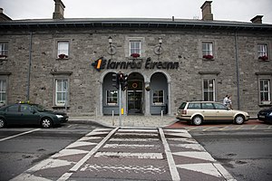
Athlone railway station
Train stop in central Ireland
Distance: Approx. 1113 meters
Latitude and longitude: 53.42722222,-7.93666667
Athlone railway station is a station which serves the town of Athlone in County Roscommon and County Westmeath. It is located in the town on the east side of the river Shannon. The station is an interchange station between the Dublin-Galway and Dublin-Westport rail services.

Sean's Bar
Claimed oldest pub in Ireland
Distance: Approx. 1287 meters
Latitude and longitude: 53.42267,-7.94236
Sean's Bar is a pub in Athlone, Ireland, notable for its reputed establishment in AD 900, and claim to being the oldest extant bar in Ireland. However, architectural and archaeological records, including the Record of Monuments and Places and the National Inventory of Architectural Heritage, date the building to the 17th or 18th century.

Midland Region, Ireland
NUTS 3 region in Ireland
Distance: Approx. 1188 meters
Latitude and longitude: 53.42361111,-7.9425
The Midland Region (coded IE063) is a NUTS Level III statistical region of Ireland. It consists of the territory of the counties of Laois, Offaly, Westmeath and Longford. The Midland Region spans 6,652 km2, 9.5% of the total area of the state and, according to the 2022 census, had a population of 317,999.

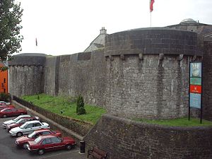
Athlone Castle
12th century castle in Westmeath, Ireland
Distance: Approx. 1216 meters
Latitude and longitude: 53.42333333,-7.9425
Athlone Castle, sometimes known as Adamson Castle, is a castle located in Athlone, County Westmeath, Ireland, dating from the 12th century.

Siege of Athlone (1690)
Irish Williamite-Jacobite War battle
Distance: Approx. 0 meters
Latitude and longitude: 53.4333,-7.95
The siege of Athlone was part of the Williamite War in Ireland between the supporters of King James II, who were known as Jacobites, and the supporters of King William of Orange. The siege began on 17 July 1690, when Williamite Lieutenant-General James Douglas arrived outside the Jacobite held city of Athlone with ten regiments of foot and five regiments of horse for a total force of 12,000. The Governor of Athlone, Colonel Richard Grace decided to defend the western part of the city.

Athlone Railway Bridge
Bridge in Athlone
Distance: Approx. 731 meters
Latitude and longitude: 53.4272,-7.9459
The Athlone Railway Bridge, also known as the White Bridge, is a railway bridge over the River Shannon at Athlone, Ireland.

Luan Gallery
Art gallery in County Westmeath, Ireland
Distance: Approx. 1156 meters
Latitude and longitude: 53.42382,-7.94287
The Luan Gallery is a publicly owned art gallery in Athlone, Westmeath, Ireland. The gallery opened in 2012, and the building consists of the older part, a former public library built in 1897 as a temperance hall, combined with a newer wing, designed by Keith Williams. The building was named Best Cultural Building of 2013 by the RIAI, and received a Civic Trust Award in 2014.

Custume Barracks
Irish military installation
Distance: Approx. 938 meters
Latitude and longitude: 53.42514,-7.94649
Custume Barracks (Irish: Dún Chostúim) is a military installation at Athlone in Ireland.

Church of Saints Peter and Paul, Athlone
Church in County Westmeath, Ireland
Distance: Approx. 1125 meters
Latitude and longitude: 53.423924,-7.943669
The Church of Saints Peter and Paul is a Roman Catholic parish church situated in the town of Athlone, County Westmeath in Ireland.
Athlone (townland)
Distance: Approx. 1186 meters
Latitude and longitude: 53.4249,-7.939
Athlone is the name given to two bordering townlands in County Westmeath, Ireland. The townlands are in the civil parish of St. Mary's.
Weather in this IP's area
clear sky
-1 Celsius
-5 Celsius
-1 Celsius
-1 Celsius
1003 hPa
94 %
1003 hPa
997 hPa
10000 meters
2.68 m/s
4.44 m/s
4 degree
8 %
