Country:
 United Arab Emirates
Region:
City:
Latitude and Longitude:
Time Zone:
Postal Code:
IP information under different IP Channel
ip-api
Country
Region
City
ASN
Time Zone
ISP
Blacklist
Proxy
Latitude
Longitude
Postal
Route
IPinfo
Country
Region
City
ASN
Time Zone
ISP
Blacklist
Proxy
Latitude
Longitude
Postal
Route
MaxMind
Country
Region
City
ASN
Time Zone
ISP
Blacklist
Proxy
Latitude
Longitude
Postal
Route
Luminati
Country
AERegion
az
City
abudhabi
ASN
Time Zone
Asia/Dubai
ISP
Emirates Integrated Telecommunications Company PJSC
Latitude
Longitude
Postal
db-ip
Country
Region
City
ASN
Time Zone
ISP
Blacklist
Proxy
Latitude
Longitude
Postal
Route
ipdata
Country
Region
City
ASN
Time Zone
ISP
Blacklist
Proxy
Latitude
Longitude
Postal
Route
Popular places and events near this IP address
The British School – Al Khubairat
School in Abu Dhabi, United Arab Emirates
Distance: Approx. 2063 meters
Latitude and longitude: 24.4480774,54.3867874
The British School Al Khubairat, formerly called "Al Khubairat Community School", now commonly known and referred to as "Al Khubairat" or "BSAK", is a non-profit fee-charging school for English speaking children in Abu Dhabi, United Arab Emirates. The school roll is some 1800 students.
Al Mushrif
Neighborhood in abu dhabi
Distance: Approx. 2295 meters
Latitude and longitude: 24.4506,54.3837
Al Mushrif is a central neighborhood in the city of Abu Dhabi zone one, United Arab Emirates. Al-Mushrif is located in an area between Sheikh Rashid Bin Saeed Street "Airport Road" and Arabian Gulf Street, which extends to Mussafah Bridge. It is the location of the Al Mushrif Palace and Umm Al Emarat Park, as well as Mushrif Mall.
St Joseph's School (Abu Dhabi)
Catholic Private School in Abu Dhabi, United Arab Emirates
Distance: Approx. 2202 meters
Latitude and longitude: 24.44839,54.38523
St Joseph's School (SJS) is a primary to secondary school in Abu Dhabi, United Arab Emirates and is next to St. Joseph's Cathedral, Abu Dhabi.
Al Nahyan, Abu Dhabi
Neighbourhood in Abu Dhabi, UAE
Distance: Approx. 2683 meters
Latitude and longitude: 24.46666667,54.38333333
Al Nahyan is a neighbourhood in Abu Dhabi, United Arab Emirates. Al Nahyan is named after the Al Nahyan family. It is the location of the Al Nahyan Stadium, which is also named after them.
Salam Street
Main road in the city of Abu Dhabi
Distance: Approx. 2868 meters
Latitude and longitude: 24.44483333,54.43236111
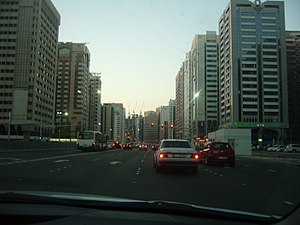
Salam Street (Arabic: شَارِع ٱلسَّلَام, romanized: Shāriʿ As-Salām), now renamed as "Sheikh Zayed bin Sultan Street" (Arabic: شَارِع ٱلشَّيْخ زَايِد بِن سُلْطَان, romanized: Shāriʿ Ash-Shaykh Zāyid Bin Sulṭān), and less commonly known as 8th Street or Eastern Ring Road, is one of the main roads in the city of Abu Dhabi. It starts from Sheikh Zayed Bridge and curves its way around Abu Dhabi's eastern end until it ends at the intersection with Corniche Road. Salam Street runs through the main modern shopping area and Robat Street, the new bypass north of the town.
St. Joseph's Cathedral, Abu Dhabi
Seat of The Apostolic Vicar of Southern Arabia
Distance: Approx. 2168 meters
Latitude and longitude: 24.44912583,54.3853493
St. Joseph's Cathedral is the seat of the Apostolic Vicar of Southern Arabia and is one of the five Catholic churches in the Emirate of Abu Dhabi besides St. Paul's Church in Musaffah, St.

Mushrif Mall
Shopping mall in Abu Dhabi, United Arab Emirates
Distance: Approx. 2333 meters
Latitude and longitude: 24.4342291,54.4129855
Mushrif Mall is a three-level shopping mall that is located in the city of Abu Dhabi, on Rashid bin Saeed and Al Dhafra Streets. The mall houses Lulu Hypermarket, fish, meat, fruit and vegetables market, retail outlets, restaurants, cafeterias, coffee shops, entertainment and fun areas. The mall is owned by LuLu Group International and was opened in 2011.
Khalifa University
University in the United Arab Emirates
Distance: Approx. 1355 meters
Latitude and longitude: 24.44736,54.39494
Khalifa University (Arabic: جامعة خليفة) is a research, innovation and enterprise-intensive public university located in Abu Dhabi, United Arab Emirates. Khalifa University's current president, His Excellency Professor Ebrahim Al Hajri, was appointed in July 2024. The university has 5,000 students.
Al Bahr Towers
Offices in Abu Dhabi, United Arab Emirates
Distance: Approx. 582 meters
Latitude and longitude: 24.4566,54.4009
Al Bahr Towers is a development in the emirate of Abu Dhabi consisting of two 29-storey, 145m–high towers. It is located at the intersection of Al Saada and Al Salam Street in Abu Dhabi City, the capital of the United Arab Emirates, at the eastern entrance. One tower houses the new headquarters of the Abu Dhabi Investment Council (ADIC), an investment arm of the Government of Abu Dhabi.

Mary, Mother of Jesus Mosque
Mosque in Abu Dhabi
Distance: Approx. 2101 meters
Latitude and longitude: 24.449917,54.385806
Mary, Mother of Jesus Mosque, also called in Arabic, Maryam Umm Eisa Masjid (Arabic: مسجد مريم أم عيسى عليهما السلام, Masjid Maryam Umm ‘Īsā) is a mosque located in Al Mushrif, a central neighborhood in the city of Abu Dhabi, the capital city of the United Arab Emirates. It was built in 1989 as Mohammed Bin Zayed Mosque, and named after Mohammed bin Zayed Al Nahyan, Ruler of Abu Dhabi. On 14 June 2017, Sheikh Mohammed bin Zayed Al Nahyan decided to rename the mosque to "Mary, Mother of Jesus Mosque".
Umm Al Emarat Park
Distance: Approx. 2525 meters
Latitude and longitude: 24.452,54.3812
Umm Al Emarat Park, previously known as Mushrif Park, is an urban park in Abu Dhabi, in the United Arab Emirates, centrally located on 15th Street between Airport Road and Karamah Street. First opened in 1982, entrance to the park was originally exclusive to women and children, but it has since become accessible to all visitors. Over 80,000 students have visited the park through its partnerships with 400 UAE schools, with the aim of teaching the youth about the country's ecosystem, and heritage, and wildlife.
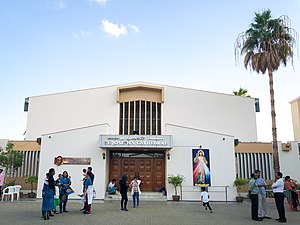
St. Therese Church, Abu Dhabi
Catholic Church in Abu Dhabi
Distance: Approx. 2168 meters
Latitude and longitude: 24.44912583,54.3853493
St. Therese of the Child Jesus Church, Abu Dhabi (commonly known as St. Therese Church) is a Catholic church located in Abu Dhabi, the capital city of the United Arab Emirates.
Weather in this IP's area
clear sky
36 Celsius
41 Celsius
36 Celsius
37 Celsius
1005 hPa
44 %
1005 hPa
1004 hPa
10000 meters
4.63 m/s
150 degree
06:06:19
18:34:04