91.244.126.229 - IP Lookup: Free IP Address Lookup, Postal Code Lookup, IP Location Lookup, IP ASN, Public IP
Country:
 Finland
Region:
City:
Location:
Time Zone:
Postal Code:
ISP:
ASN:
language:
User-Agent:
Proxy IP:
Blacklist:
IP information under different IP Channel
ip-api
Country
Region
City
ASN
Time Zone
ISP
Blacklist
Proxy
Latitude
Longitude
Postal
Route
db-ip
Country
Region
City
ASN
Time Zone
ISP
Blacklist
Proxy
Latitude
Longitude
Postal
Route
IPinfo
Country
Region
City
ASN
Time Zone
ISP
Blacklist
Proxy
Latitude
Longitude
Postal
Route
IP2Location
91.244.126.229Country
fiRegion
kymenlaakso
City
kuusankoski
Time Zone
Europe/Helsinki
ISP
Language
User-Agent
Latitude
Longitude
Postal
ipdata
Country
Region
City
ASN
Time Zone
ISP
Blacklist
Proxy
Latitude
Longitude
Postal
Route
Popular places and events near this IP address

Kouvola
City in Kymenlaakso, Finland
Distance: Approx. 6120 meters
Latitude and longitude: 60.86805556,26.70416667
Kouvola (Finnish pronunciation: [ˈkou̯ʋolɑ]) is a city in Finland and the administrative capital of Kymenlaakso. It is located in the southeastern interior of the country. The population of Kouvola is approximately 78,000.

Kuusankoski
District of Kouvola in Southern Finland, Finland
Distance: Approx. 154 meters
Latitude and longitude: 60.90833333,26.62361111
Kuusankoski is a neighbourhood of city of Kouvola, former industrial town and municipality of Finland, located in the region of Kymenlaakso in the province of Southern Finland. The population of Kuusankoski was 20,392 (2003) and the total area was 129.5 km2 of which 114 km2 was land and 14.56 km2 water. It is located some 130 kilometres (80 mi) northeast of the Finnish capital Helsinki.

Koria
Village in Kymenlaakso, Finland
Distance: Approx. 8306 meters
Latitude and longitude: 60.83333333,26.6
Koria is an unincorporated village in the region of Kymenlaakso, Finland. It is under the administration of the town of Kouvola. It is located on Finnish national road 6 6.7 km west of Kouvola and 129 km from Helsinki.

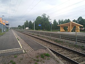
Kouvola railway station
Railway station in Kouvola, Finland
Distance: Approx. 6300 meters
Latitude and longitude: 60.8662,26.705
The Kouvola railway station (Finnish: Kouvolan rautatieasema, Swedish: Kouvola järnvägsstation) is located in the city of Kouvola in Finland. The Kouvola railway station is an important crossing point station. It is located about 130 kilometres (80 mi) from the Helsinki Central railway station.

Kouvolan keskuskenttä
Stadium in Kouvola, Finland
Distance: Approx. 6199 meters
Latitude and longitude: 60.87194444,26.71333333
Keskusurheilukenttä is a multi-use stadium in Kouvola, Finland. It is used mostly for football matches and is the home stadium of the bandy club Kouvolan Sudet (Wolves). The stadium has an capacity of 12,000 spectators.

Nappa, Finland
Distance: Approx. 6724 meters
Latitude and longitude: 60.85,26.58333333
Nappa is an ostentatious village in northern Kymenlaakso. It emerged in mid-17th century arising from the residential area and is now part of Kouvola and has grown to more than a thousand inhabitants.

Kymi Ring
Motor Racing Circuit in Finland
Distance: Approx. 8396 meters
Latitude and longitude: 60.87722222,26.48194444
The KymiRing is a motor racing circuit in Kausala of the Iitti municipality, Päijänne Tavastia, Finland, bordering the Kymenlaakso's regional capital Kouvola, and located 110-kilometre (68 mi) north-east of the capital Helsinki. It was planned that it would be the first circuit in Finland to hold an FIA Grade 1 license. While the circuit itself was built to meet both Formula 1 and MotoGP specifications, hosting a Formula 1 Grand Prix would require substantial investment in both the track's facilities and in race hosting fees.

Lumon arena
Ice hockey arena in Finland
Distance: Approx. 6055 meters
Latitude and longitude: 60.8725,26.71083333
Lumon arena is an ice hockey arena located in Kouvola, Finland. The arena has a seating capacity of about 5,950. The arena's official public record is from the 1985, I-Divisioona match KooKoo against SaiPa, followed by 5350 spectators.

St. Ursula's Church, Kouvola
Church in Kouvola, Finland
Distance: Approx. 5557 meters
Latitude and longitude: 60.8712,26.6959
The St. Ursula's Church is a Roman Catholic church in Kouvola, Finland. The congregation was founded in 1985, and at first the masses were celebrated in an apartment.

Kouvola Town Hall
Seat of municipal government in Kouvola, Finland
Distance: Approx. 5854 meters
Latitude and longitude: 60.870256,26.701733
Kouvola Town hall (Finnish: Kouvolan kaupungintalo) is the seat of municipal government of City of Kouvola, Finland. The building was designed by architect Juha Leiviskä together with Bertel Saarnio, and completed in 1968. It is considered to be the breakthrough work of Juha Leiviskä.
Koria railway station
Railway station in Kouvola, Finland
Distance: Approx. 6763 meters
Latitude and longitude: 60.84724,26.6019
The Koria railway station (Finnish: Korian rautatieasema, Swedish: Koria järnvägsstation) is located in the town of Kouvola, Finland, in the urban area and district of Koria. It is located along the Lahti–Kouvola railway, and its neighboring stations are Kausala in the west and Kouvola in the east.

Kouvola Pesäpallo Stadium
Pesäpallo stadium in Kouvola, Finland
Distance: Approx. 6131 meters
Latitude and longitude: 60.871484,26.710925
Kouvola Pesäpallo Stadium is a pesäpallo stadium located in Kouvola, Finland. Since its opening it has been the home field of the Kouvolan Pallonlyöjät, a Superpesis team. The Kouvola Pesäpallo Stadium is located in the city centre, in the Kouvola Sports Park, next to the Lumon arena and the athletics field.
Weather in this IP's area
light snow
-3 Celsius
-9 Celsius
-3 Celsius
-3 Celsius
1018 hPa
96 %
1018 hPa
1009 hPa
5000 meters
5.14 m/s
10 degree
100 %