Country:
Region:
City:
Latitude and Longitude:
Time Zone:
Postal Code:
IP information under different IP Channel
ip-api
Country
Region
City
ASN
Time Zone
ISP
Blacklist
Proxy
Latitude
Longitude
Postal
Route
Luminati
Country
ASN
Time Zone
Europe/Warsaw
ISP
Rdinet Sp. Z O.o.
Latitude
Longitude
Postal
IPinfo
Country
Region
City
ASN
Time Zone
ISP
Blacklist
Proxy
Latitude
Longitude
Postal
Route
db-ip
Country
Region
City
ASN
Time Zone
ISP
Blacklist
Proxy
Latitude
Longitude
Postal
Route
ipdata
Country
Region
City
ASN
Time Zone
ISP
Blacklist
Proxy
Latitude
Longitude
Postal
Route
Popular places and events near this IP address

Okęcie
Neighborhood of Warsaw
Distance: Approx. 392 meters
Latitude and longitude: 52.18333333,20.95
Okęcie (Polish pronunciation: [ɔˈkɛɲtɕɛ]) is the largest neighbourhood of the Włochy district of Warsaw, Poland. It is the location of Warsaw Chopin Airport and the PZL Warszawa-Okęcie aircraft works, and home to the Okęcie Warszawa professional association football club. In 1939–1951 the village was a seat of Okęcie gmina.

LOT Polish Airlines Flight 007
1980 Polish aviation accident
Distance: Approx. 422 meters
Latitude and longitude: 52.18513889,20.94619444
LOT Polish Airlines Flight 007 was an Ilyushin Il-62 that crashed near Okęcie Airport in Warsaw, Poland, on 14 March 1980, as the crew aborted a landing and attempted to go-around. All 87 crew and passengers died. It was caused by the disintegration of one of the turbine discs in one of the plane's engines, leading to uncontained engine failure.
SprintAir
Polish airline
Distance: Approx. 712 meters
Latitude and longitude: 52.1751,20.947
SprintAir S.A. is a Polish airline headquartered in Warsaw and based at Warsaw Frederic Chopin Airport. It operates cargo services and passenger charter flights.

Institute of Aviation, Warsaw
Distance: Approx. 363 meters
Latitude and longitude: 52.18,20.95
The Institute of Aviation or Warsaw Institute of Aviation (Polish Instytut Lotnictwa) is a research and development center established in 1926, located in Warsaw, Poland. The activities of the facility focus on providing design, engineering and research services in the field of aviation and aerospace. The institute conducts international cooperation with European Union and transatlantic countries in the following areas (primarily with General Electric under the Engineering Design Center): aircraft engines, aerodynamics, aircraft structures and materials research.

Warszawa Rakowiec railway station
Railway station in Warsaw, Poland
Distance: Approx. 2231 meters
Latitude and longitude: 52.19666667,20.96638889
Warszawa Rakowiec railway station is a railway station in the Ochota district of Warsaw, Poland. It is served by Koleje Mazowieckie, who run services from Warszawa Wschodnia to Góra Kalwaria or Skarżysko-Kamienna.

1962 LOT Vickers Viscount Warsaw crash
Distance: Approx. 2294 meters
Latitude and longitude: 52.16583333,20.96722222
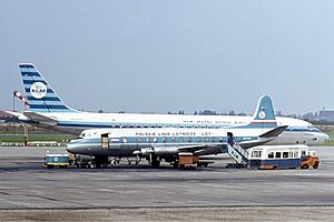
The 1962 LOT Vickers Viscount Warsaw crash occurred on 19 December 1962 when a Vickers Viscount 804, operated by LOT Polish Airlines on a flight from Brussels to Warsaw, crashed on landing. All passengers and crew died. The plane was returning from Brussels, and had a mid-way landing in Berlin from where it took off at 5:55 pm.
Zbarż
Distance: Approx. 2198 meters
Latitude and longitude: 52.1667,20.9667
Zbarż is a locality within the borough of Włochy and a former village. It was established some time in 13th or 14th century. Granted with Magdeburg Law by Prince Bolesław IV of Warsaw, it was home to the Zbarski family until 1528, when Mazovia was annexed by Poland and the village was taken over by Babicki family.

Załuski, Warsaw
Neighbourhood and a City Information System area in Warsaw, Masovian Voivodeship, Poland
Distance: Approx. 1419 meters
Latitude and longitude: 52.16916667,20.93936111
Załuski is a neighbourhood, and an area of the City Information System, in the city of Warsaw, Poland, located within the district of Włochy.

Salomea, Warsaw
Neighbourhood and a Municipal Information System area in Warsaw, Masovian Voivodeship, Poland
Distance: Approx. 1568 meters
Latitude and longitude: 52.18976667,20.92672222
Salomea is a neighbourhood, and an area of the Municipal Information System, in the city of Warsaw, Poland, located within the district of Włochy.

Wawrzyszew, Warsaw
Neighbourhood of Warsaw, Poland
Distance: Approx. 1412 meters
Latitude and longitude: 52.17140278,20.932475
Wawrzyszew is a neighbourhood, and a City Information System area, in Warsaw, Poland, located within the district of Bielany.

Opacz Wielka
Neighbourhood of Warsaw, Poland
Distance: Approx. 1644 meters
Latitude and longitude: 52.18166667,20.92111111
Opacz Wielka is a neighbourhood, and City Information System area, in the city of Warsaw, Poland. It is a residential area consisting of single-family detached homes. The oldest records that mention it date to the early 16th century.

Centrum Łopuszańska 22
Shopping centre in Warsaw, Poland
Distance: Approx. 1247 meters
Latitude and longitude: 52.19194444,20.95138889
Centrum Łopuszańska 22 is a shopping centre in Warsaw, Poland, located at 22 Łopuszańska Street, within the district of Włochy. It was opened in 2015.
Weather in this IP's area
clear sky
3 Celsius
1 Celsius
1 Celsius
3 Celsius
1032 hPa
92 %
1032 hPa
1019 hPa
10000 meters
1.79 m/s
2.04 m/s
218 degree
8 %
06:37:25
16:02:07
