91.238.17.86 - IP Lookup: Free IP Address Lookup, Postal Code Lookup, IP Location Lookup, IP ASN, Public IP
Country:
Region:
City:
Location:
Time Zone:
Postal Code:
ISP:
ASN:
language:
User-Agent:
Proxy IP:
Blacklist:
IP information under different IP Channel
ip-api
Country
Region
City
ASN
Time Zone
ISP
Blacklist
Proxy
Latitude
Longitude
Postal
Route
db-ip
Country
Region
City
ASN
Time Zone
ISP
Blacklist
Proxy
Latitude
Longitude
Postal
Route
IPinfo
Country
Region
City
ASN
Time Zone
ISP
Blacklist
Proxy
Latitude
Longitude
Postal
Route
IP2Location
91.238.17.86Country
Region
mykolaivska oblast
City
mykolayiv
Time Zone
Europe/Kiev
ISP
Language
User-Agent
Latitude
Longitude
Postal
ipdata
Country
Region
City
ASN
Time Zone
ISP
Blacklist
Proxy
Latitude
Longitude
Postal
Route
Popular places and events near this IP address

Mykolaiv
City and administrative center of Mykolaiv Oblast, Ukraine
Distance: Approx. 1007 meters
Latitude and longitude: 46.975,31.995
Mykolaiv (Ukrainian: Миколаїв, IPA: [mɪkoˈlɑjiu̯] ; Russian: Николаев, romanized: Nikolayev [nʲɪkɐˈɫa(j)ɪf]) is a city and a hromada (municipality) in southern Ukraine. Mykolaiv is the administrative center of Mykolaiv Raion (district) and Mykolaiv Oblast (province). The city of Mykolaiv, which provides Ukraine with access to the Black Sea, is the location of the most downriver bridge crossing of the Southern Bug river.

Mykolaiv Observatory
Observatory
Distance: Approx. 2010 meters
Latitude and longitude: 46.97284631,31.97285169
Mykolaiv Observatory (full name: Research Institute “Mykolaiv Astronomical Observatory”, Ukrainian: Науково-дослідницький інститут «Миколаївська астрономічна обсерваторія») is an astronomical observatory in Mykolaiv, Ukraine.

Mykolayiv Shipyard
Shipyard in Mykolaiv, Ukraine
Distance: Approx. 1258 meters
Latitude and longitude: 46.9764,32.0042
Mykolaiv Shipyard (Ukrainian: Миколаївський суднобудівний завод) (Russian: Николаевский судостроительный завод) was a major shipyard located in Mykolaiv, Ukraine. Originally named the Nikolayev Admiralty, and constructed in 1788 for the purpose of supplying the Russian Black Sea Fleet, the Mykolaiv Shipyard was famous for having built warships such as Vitse-admiral Popov, Knyaz' Potemkin-Tavricheskiy and Imperator Nikolai I for the Russian Empire, and Soobrazitelny, Gnevny, Nikolayev and Slava for the Soviet Union. Until 2017, the shipyard was named as the Shipyard named after 61 Communards, a name inherited from its period as a major Soviet Navy shipyard.The shipyard has also been referred to as the Mykolaiv North Shipyard, to differentiate it from the Black Sea Shipyard present in the same city.

Mykolaiv National Agrarian University
Public university in Mykolaiv, Ukraine
Distance: Approx. 2428 meters
Latitude and longitude: 46.96478,31.9655
Mykolaiv National Agrarian University (also known as MNAU, Ukrainian: Миколаївський національний аграрний університет (МНАУ)) is a public agricultural college in Mykolaiv, Ukraine.

Ukrainian cruiser Ukraina
Unfinished guided missile cruiser
Distance: Approx. 1125 meters
Latitude and longitude: 46.975271,32.003618
Ukraina (Ukrainian: Україна) is a Ukrainian Slava-class cruiser originally ordered by the Soviet Union in the early 1980s under the name Admiral Flota Lobov (Russian: Адмирал Флота Лобов, "Fleet Admiral Lobov"). After the Soviet Union disbanded in the early 1990s, the ship passed on to Russia and then to Ukraine, assuming the name Ukraina. In 2010 the Ukrainian parliament stripped the ship of her name.
The V. V. Vereshchagin Mykolaiv Art Museum
Art Museum in Ukraine, Mykolaiv
Distance: Approx. 1173 meters
Latitude and longitude: 46.973215,31.986008
The V. V. Vereshchagin Mykolaiv Art Museum (Ukrainian: Миколаївський обласний художній музей імені В. В. Верещагіна) is the museum of art, which is located in Mykolaiv, Ukraine.

Museum of Shipbuilding and the Fleet
Distance: Approx. 1583 meters
Latitude and longitude: 46.97805556,31.98611111
The Museum of Shipbuilding and Fleet (Ukrainian: Музей суднобудування і флоту) is a museum dedicated to shipbuilding located in Mykolaiv, Ukraine.
Nibulon Shipyard
Distance: Approx. 2127 meters
Latitude and longitude: 46.948079,31.988091
NIBULON Shipbuilding and Shiprepair Yard (Ukrainian: Суднобудівно-судноремонтний завод «Нібулон») is a Ukrainian shipyard that is located in Mykolaiv owned by agricultural company NIBULON. It is located right next to the Black Sea Shipyard.

Dykyi Sad archaeological site
Historic site
Distance: Approx. 1987 meters
Latitude and longitude: 46.981,31.983
The Dykyi Sad archaeological site constitutes the remains of a fortified Cimmerian settlement, an ancient port city discovered in the Dykyi Sad park (Ukrainian: Дикий Сад, lit. 'Wild Garden') in Mykolaiv, Ukraine.

Battle of Mykolaiv
Battle in the Russian invasion of Ukraine
Distance: Approx. 1007 meters
Latitude and longitude: 46.975,31.995
The battle of Mykolaiv started on the night of 26 February 2022, as part of the southern Ukraine campaign during the Russian invasion of Ukraine. It ended with Russian forces being repulsed from the city in March, and by April all but a few of its surrounding villages were back under Ukrainian control.

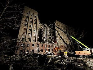
Mykolaiv government building missile strike
Distance: Approx. 976 meters
Latitude and longitude: 46.97487,31.99763
On 29 March 2022, Russian forces carried out a missile strike (supposedly using Kalibr missile) on the Mykolaiv Regional State Administration's headquarters during the battle of Mykolaiv. It resulted in at least 37 deaths and 34 injuries.
Port of Mykolaiv
Port in Ukraine
Distance: Approx. 1807 meters
Latitude and longitude: 46.95066667,32.00475
Mykolaiv Sea Commercial Port (formerly Nikolaev) is one of the leading state enterprises in the transport sector of Ukraine for processing, exports, imports, and cabotage cargo, that provides transit transportation of various cargoes, both general and bulk. According to the Law of Ukraine "About seaports of Ukraine" functions of the Mikolaiv Seaport Authority are carried out by the Mikolaiv branch of the state enterprise of the Ukrainian Sea Ports Authority. In 2013, as a result of the reform of the maritime sector of Ukraine, the state enterprise "Ukrainian Sea Ports Authority" was established to manage state property in seaports and its effective use, create mechanisms to attract investment in the port infrastructure for its development and stable business.
Weather in this IP's area
overcast clouds
6 Celsius
4 Celsius
6 Celsius
6 Celsius
1019 hPa
93 %
1019 hPa
1014 hPa
10000 meters
2.76 m/s
4.75 m/s
102 degree
89 %

