91.237.106.79 - IP Lookup: Free IP Address Lookup, Postal Code Lookup, IP Location Lookup, IP ASN, Public IP
Country:
Region:
City:
Location:
Time Zone:
Postal Code:
IP information under different IP Channel
ip-api
Country
Region
City
ASN
Time Zone
ISP
Blacklist
Proxy
Latitude
Longitude
Postal
Route
Luminati
Country
Region
y
City
kramfors
ASN
Time Zone
Europe/Stockholm
ISP
84 Grams AB
Latitude
Longitude
Postal
IPinfo
Country
Region
City
ASN
Time Zone
ISP
Blacklist
Proxy
Latitude
Longitude
Postal
Route
IP2Location
91.237.106.79Country
Region
vasternorrlands lan
City
kramfors
Time Zone
Europe/Stockholm
ISP
Language
User-Agent
Latitude
Longitude
Postal
db-ip
Country
Region
City
ASN
Time Zone
ISP
Blacklist
Proxy
Latitude
Longitude
Postal
Route
ipdata
Country
Region
City
ASN
Time Zone
ISP
Blacklist
Proxy
Latitude
Longitude
Postal
Route
Popular places and events near this IP address

Kramfors Municipality
Municipality in Västernorrland County, Sweden
Distance: Approx. 1206 meters
Latitude and longitude: 62.93333333,17.8
Kramfors Municipality (Kramfors kommun) is a municipality in Västernorrland County, northern Sweden. Its seat is located in the town Kramfors. The rural municipality of Gudmundrå was in 1947 made one of the last administrative cities of Sweden and got the name Kramfors from an industrial settlement.

Norrland County
Distance: Approx. 5660 meters
Latitude and longitude: 62.9167,17.8833
Norrland County, or Norrlands län, was a county of the Swedish Empire from 1634 to 1645. In 1638 the northern part of the county, Västerbotten and Lappland, were separated and established as the Västerbotten County. On 5 September 1645 the remainder of the county was divided in two parts where the central part became the Härnösand County and the southern part became the Hudiksvall County.

Kramfors
Place in Ångermanland, Sweden
Distance: Approx. 1206 meters
Latitude and longitude: 62.93333333,17.8
Kramfors (Swedish pronunciation: [ˈkrɑ̂ːmfɔʂ]) is a locality and the seat of Kramfors Municipality in Västernorrland County, Sweden. It had a population of 5,990 inhabitants in 2010. The town grew on the western bank of the Ångerman river in the 19th century as harvested logs were floated downriver to be processed at local sawmills and pulp mills.

Ådalen shootings
1931 Swedish anti-labour massacre
Distance: Approx. 7439 meters
Latitude and longitude: 62.88138889,17.87333333
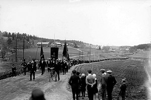
The Ådalen shootings (Swedish: skotten i Ådalen) was a series of events in and around the sawmill district of Ådalen, Kramfors Municipality, Ångermanland, Sweden, in May 1931. During a protest on 14 May, five people were killed by bullets fired by Swedish military personnel called in as reinforcements by the police.
Ådalen
Distance: Approx. 7731 meters
Latitude and longitude: 63,17.75
Ådalen [ˈoːˌdɑlən] is the river valley of the Ångerman River, downstream Junsele, in Sweden. It often refers to the broad, densely populated, fjord-like mouth of the river, in Kramfors Municipality, and is known for the May 1931 Ådalen shootings.

Sandö Bridge
Bridge
Distance: Approx. 7411 meters
Latitude and longitude: 62.8833,17.8771
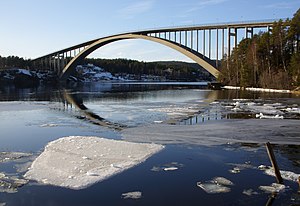
The Sandö Bridge (Swedish: Sandöbron) is a concrete arch bridge crossing the Ångerman River in Kramfors Municipality in northern Sweden. It has a free span of 264 meters and is 42 meters above the water. The surrounding area is often referred to as The High Coast.
Frånö
Place in Ångermanland, Sweden
Distance: Approx. 4547 meters
Latitude and longitude: 62.9,17.83333333
Frånö was a locality situated in Kramfors Municipality, Västernorrland County, Sweden with 640 inhabitants in 2010. Since 2015, it is included in the urban area of Kramfors.
Klockestrand
Place in Ångermanland, Sweden
Distance: Approx. 8251 meters
Latitude and longitude: 62.88333333,17.9
Klockestrand is a locality situated in Kramfors Municipality, Västernorrland County, Sweden with 315 inhabitants in 2010.
Lunde, Sweden
Place in Ångermanland, Sweden
Distance: Approx. 7054 meters
Latitude and longitude: 62.88333333,17.86666667
Lunde is a locality situated in Kramfors Municipality, Västernorrland County, Sweden with 399 inhabitants in 2010.
Lugnvik
Place in Ångermanland, Sweden
Distance: Approx. 6938 meters
Latitude and longitude: 62.94619444,17.90969444
Lugnvik is a locality situated in Kramfors Municipality, Västernorrland County, Sweden with 349 inhabitants in 2010.
Bjärtrå
Parish in Västernorrland County, Sweden
Distance: Approx. 7348 meters
Latitude and longitude: 62.98333333,17.86666667
Bjärtrå is a parish of the province of Ångermanland in Sweden. Since 1974 it has been administered as part of the Kramfors Municipality. The parish has an area of 158 square kilometres, and in the year 2000 there were 1,687 inhabitants.
Norrland (village)
Distance: Approx. 5777 meters
Latitude and longitude: 62.9243,17.8894
Norrland is a part of Lugnvik, and formerly a village in Bjärtrå, Ångermanland, Sweden.
Weather in this IP's area
scattered clouds
-18 Celsius
-24 Celsius
-18 Celsius
-18 Celsius
1029 hPa
85 %
1029 hPa
1010 hPa
10000 meters
2.06 m/s
320 degree
27 %


