91.236.33.53 - IP Lookup: Free IP Address Lookup, Postal Code Lookup, IP Location Lookup, IP ASN, Public IP
Country:
Region:
City:
Location:
Time Zone:
Postal Code:
ISP:
ASN:
language:
User-Agent:
Proxy IP:
Blacklist:
IP information under different IP Channel
ip-api
Country
Region
City
ASN
Time Zone
ISP
Blacklist
Proxy
Latitude
Longitude
Postal
Route
db-ip
Country
Region
City
ASN
Time Zone
ISP
Blacklist
Proxy
Latitude
Longitude
Postal
Route
IPinfo
Country
Region
City
ASN
Time Zone
ISP
Blacklist
Proxy
Latitude
Longitude
Postal
Route
IP2Location
91.236.33.53Country
Region
dolnoslaskie
City
lubin
Time Zone
Europe/Warsaw
ISP
Language
User-Agent
Latitude
Longitude
Postal
ipdata
Country
Region
City
ASN
Time Zone
ISP
Blacklist
Proxy
Latitude
Longitude
Postal
Route
Popular places and events near this IP address

Lubin
Town in Lower Silesia, Poland
Distance: Approx. 502 meters
Latitude and longitude: 51.39722222,16.20555556
Lubin (Polish: [ˈlubin] ; German: Lüben, Silesian: Lubin) is a city in Lower Silesian Voivodeship in south-western Poland. It is the administrative seat of Lubin County, and also of the rural district called Gmina Lubin, although it is not part of the territory of the latter, as the town forms a separate urban gmina. As of 2021, the city had a total population of 70,815.

Lubin County
County in Lower Silesian Voivodeship, Poland
Distance: Approx. 157 meters
Latitude and longitude: 51.4,16.2
Lubin County (Polish: powiat lubiński) (German:Lüben Kreis) is a unit of territorial administration and local government (powiat) in Lower Silesian Voivodeship, south-western Poland. It came into being on January 1, 1999, as a result of the Polish local government reforms passed in 1998. The county covers an area of 712 square kilometres (274.9 sq mi).

Lubin Stadium
Football stadium located in Lubin, Poland
Distance: Approx. 1460 meters
Latitude and longitude: 51.41395,16.19826111
The Lubin Stadium (Polish: Stadion w Lubinie), branded as KGHM Zagłębie Arena for sponsorship reasons, is a football stadium located in Lubin, Poland. It is the home ground of Zagłębie Lubin. The stadium holds 16,068 people.

Lubin-Obora Airfield
Airport in Lubin, Poland
Distance: Approx. 2454 meters
Latitude and longitude: 51.42277778,16.19611111
Lubin Airfield (ICAO: EPLU) is a general aviation public use aerodrome not subject to certification, managed by the local aeroclub Aeroklub Zagłębia Miedziowego, in Lubin, Poland. It is located in the north part of the city around 3 km from its centre. The airport has a paved runway (RWY 31R/13L, 1000 m x 30 m) suitable for turboprop aircraft of the Beech Super King Air or Saab 340 class and small jet aircraft of Cessna Citation class, and two grass runways (RWY 31L/13R, 850 m x 100 m, RWY 11/29, 850 m x 100 m) for gliders and lighter aircraft.
Gmina Lubin
Gmina in Lower Silesian Voivodeship, Poland
Distance: Approx. 157 meters
Latitude and longitude: 51.4,16.2
Gmina Lubin is a rural gmina (administrative district) in Lubin County, Lower Silesian Voivodeship, in south-western Poland. Its seat is the town of Lubin, although the town is not part of the territory of the gmina. The gmina covers an area of 290.15 square kilometres (112.0 sq mi), and as of 2019 its total population is 16,052.
Gola, Lubin County
Village in Lower Silesian Voivodeship, Poland
Distance: Approx. 4199 meters
Latitude and longitude: 51.43833333,16.21027778
Gola [ˈɡɔla] is a village in the administrative district of Gmina Lubin, within Lubin County, Lower Silesian Voivodeship, in south-western Poland.
Miroszowice
Village in Lower Silesian Voivodeship, Poland
Distance: Approx. 2430 meters
Latitude and longitude: 51.38777778,16.22944444
Miroszowice [mirɔʂɔˈvit͡sɛ] is a village in the administrative district of Gmina Lubin, within Lubin County, Lower Silesian Voivodeship, in south-western Poland. The village was first mentioned in Old Polish as Micosivici in a 1267 deed.
Lubin Stadium (1985)
Football stadium in Lubin, Poland
Distance: Approx. 1402 meters
Latitude and longitude: 51.41333333,16.1975
Stadion Zagłębia Lubin (Zagłębie Lubin Stadium) was a football stadium in Lubin, Poland. It served as the home ground of Zagłębie Lubin until the Municipal Stadium opened in 2009. The stadium had a capacity of 32,430 people and opened in 1985.

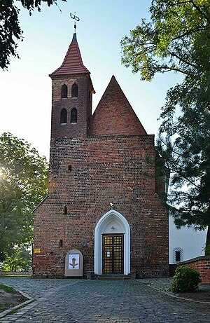
Castle Chapel in Lubin
Castle chapel in Lubin, Poland
Distance: Approx. 690 meters
Latitude and longitude: 51.39635,16.20817
The Castle Chapel in Lubin is located on Mikołaj Pruzio Street on the Castle Hill in Lubin, Poland. The chapel is the only element left from the medieval castle buildings (it originally stood next to the entrance gate in the castle courtyard). The date in the tympanum - 1349 - determines the time of construction.

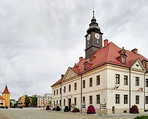
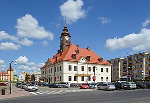
Town hall of Lubin
Local government building in Poland
Distance: Approx. 515 meters
Latitude and longitude: 51.3971,16.2056
The town hall of Lubin in Lubin, Poland, was built in 1768 in Baroque style and rebuilt in the 19th century. The building was destroyed in 1945 and then rebuilt in 1950. Currently the town hall is a seat of the Historical Museum in Lubin, as well as the mayor and the city council.

Lubin Historical Museum
City museum in Lubin, Poland
Distance: Approx. 513 meters
Latitude and longitude: 51.39731958,16.20604701
The Lubin Historical Museum is a local museum in the town of Lubin, Poland. It presents, in particular, Lubin's recent history. It is a local government cultural institution, established in 2016, and opened to the public on 17 May 2018.

Głogów Tower
Distance: Approx. 371 meters
Latitude and longitude: 51.39803,16.20401
The Głogów Tower (German: Pulverturm, Glogauer Torturm) is a Gothic building from the mid-14th century in Lubin, Lower Silesian Voivodeship, Poland, located in the northwestern part of the market square.
Weather in this IP's area
overcast clouds
3 Celsius
3 Celsius
3 Celsius
3 Celsius
1020 hPa
84 %
1020 hPa
1004 hPa
10000 meters
0.94 m/s
0.61 m/s
263 degree
100 %
