Country:
Region:
City:
Latitude and Longitude:
Time Zone:
Postal Code:
IP information under different IP Channel
ip-api
Country
Region
City
ASN
Time Zone
ISP
Blacklist
Proxy
Latitude
Longitude
Postal
Route
Luminati
Country
ASN
Time Zone
Europe/Paris
ISP
VOIP Telecom SAS
Latitude
Longitude
Postal
IPinfo
Country
Region
City
ASN
Time Zone
ISP
Blacklist
Proxy
Latitude
Longitude
Postal
Route
db-ip
Country
Region
City
ASN
Time Zone
ISP
Blacklist
Proxy
Latitude
Longitude
Postal
Route
ipdata
Country
Region
City
ASN
Time Zone
ISP
Blacklist
Proxy
Latitude
Longitude
Postal
Route
Popular places and events near this IP address

Siege of Harfleur
Siege in 1415
Distance: Approx. 1239 meters
Latitude and longitude: 49.49416667,0.13888889
The siege of Harfleur (18 August – 22 September 1415) was conducted by the English army of King Henry V in Normandy, France, during the Hundred Years' War. The defenders of Harfleur surrendered to the English on terms and were treated as prisoners of war. It was the first time that an English army made significant use of gunpowder artillery in the siege of a large urban settlement.

Stade Jules Deschaseaux
Distance: Approx. 2366 meters
Latitude and longitude: 49.50194444,0.17111111
Stade Jules Deschaseaux is a multi-purpose stadium in Le Havre, France. It is used mostly for football matches. The stadium is able to hold 16,400 people and was built in 1932.

Le Havre station
Train station in France
Distance: Approx. 1954 meters
Latitude and longitude: 49.49277778,0.12527778
Le Havre station (French: Gare du Havre) is the main railway station located in Le Havre, Seine-Maritime, France. The station was opened on 22 March 1847 and is located on the Paris–Le Havre railway. The train services are operated by SNCF. The station building was built in 1932 by Henri Pacon for the CF de l'Etat replacing the older building along with a new clock tower.

Dock Océane
Distance: Approx. 1393 meters
Latitude and longitude: 49.491116,0.132641
Dock Océane is an indoor sporting arena located in Le Havre, France. The capacity of the arena is 3,598 people. It is currently home to the Saint Thomas Basket Le Havre basketball team.

Port of Le Havre
Port in France
Distance: Approx. 1695 meters
Latitude and longitude: 49.475,0.13333333
The Port of Le Havre is the Port and port authority of the French city of Le Havre. It is the second-largest commercial port in France in terms of overall tonnage, and the largest container port, with three sets of terminals. It can accommodate all sizes of world cruise liners, and a major new marina is being planned.

Le Havre Normandy University
French university in Le Havre. Founded in 1984.
Distance: Approx. 1867 meters
Latitude and longitude: 49.49583333,0.12944444
Le Havre Normandy University (French: Université Le Havre Normandie) is a French university located in Le Havre. Along with five other schools, Le Havre Normandy University is a member of Normandy University, an association of universities and higher education institutions.

Les Bains Des Docks
Aquatic Complex in Le Havre, France
Distance: Approx. 1665 meters
Latitude and longitude: 49.48708333,0.12708333
Les Bains Des Docks (The Bath by the docks) is an Aquatic Center in the city of Le Havre, France. It was designed by award winning architectural firm Ateliers Jean Nouvel as part of an effort by Le Havre to revitalize its docks and warehouse district.

Le Havre-Graville station
Distance: Approx. 1746 meters
Latitude and longitude: 49.49972222,0.16083333
Le Havre-Graville is a station serving the Graville-Sainte-Honorine quarter of the city of Le Havre. Services are mainly regional rail. It is situated on the Paris–Le Havre railway and the Lézarde Express Régionale line to Rolleville.

U.S. Army ST-488
Distance: Approx. 1846 meters
Latitude and longitude: 49.4862,0.1245
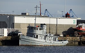
U.S. Army ST-488 is an 86 ft (26 m) harbor tugboat, design 327-A, of the numerical series 885-490 built by J.K. Welding & Co shipyards in Brooklyn, New York in 1944. The Army's ST small tugs ranged generally from about 55 ft (17 m) to 92 ft (28 m) in length as opposed to the larger seagoing LT tugs. ST-488 was delivered May 1944 and served in the United States Army from October 1944 to 1946 in the French port of Le Havre and on the floating docks of the U.S. Mulberry harbour of Arromanches in Normandy.

Stade Océane
Football stadium in Le Havre, France
Distance: Approx. 2046 meters
Latitude and longitude: 49.49888889,0.16972222
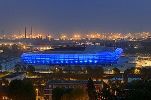
The Stade Océane (or Grand Stade du Havre) is a football stadium in Le Havre, France. Its capacity is 25,178 all-seated and it is the home ground of Ligue 1 club Le Havre AC. It replaced the Stade Jules Deschaseaux as the club's home stadium. Its inauguration was 12 July 2012, with a friendly fixture between Le Havre and Lille.

Canton of Le Havre-3
Canton in Normandy, France
Distance: Approx. 868 meters
Latitude and longitude: 49.49,0.14
The canton of Le Havre-3 is an administrative division of the Seine-Maritime department, in northern France. Its borders were modified at the French canton reorganisation which came into effect in March 2015. Its seat is in Le Havre.

Abbaye de Graville
Museum in Le Havre, France
Distance: Approx. 2264 meters
Latitude and longitude: 49.50333,0.16561031
Abbaye de Graville (Abbey of Graville) is an abbey located in the city of Le Havre, in the Normandy region of France. The architectural complex was founded in the 11th century and consists of a church, conventual buildings, a refectory, a cloister, a garden, and a cemetery. Nowadays, one of the departments of the Museum of Art and History of Le Havre (Musée d'Art et d'Histoire du Havre) is located in the Abbey.
Weather in this IP's area
overcast clouds
12 Celsius
11 Celsius
9 Celsius
12 Celsius
1015 hPa
93 %
1015 hPa
1014 hPa
10000 meters
10.29 m/s
250 degree
100 %
08:15:48
17:13:47