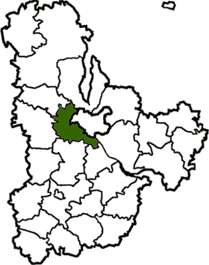
Country:
Region:
City:
Latitude and Longitude:
Time Zone:
Postal Code:
IP information under different IP Channel
ip-api
Country
Region
City
ASN
Time Zone
ISP
Blacklist
Proxy
Latitude
Longitude
Postal
Route
Luminati
Country
Region
32
City
muzychi
ASN
Time Zone
Europe/Kyiv
ISP
Obltelecom LLC
Latitude
Longitude
Postal
IPinfo
Country
Region
City
ASN
Time Zone
ISP
Blacklist
Proxy
Latitude
Longitude
Postal
Route
db-ip
Country
Region
City
ASN
Time Zone
ISP
Blacklist
Proxy
Latitude
Longitude
Postal
Route
ipdata
Country
Region
City
ASN
Time Zone
ISP
Blacklist
Proxy
Latitude
Longitude
Postal
Route
Popular places and events near this IP address
Battle on the Irpin River
Semi-legendary, supposed 1320s battle between Lithuania and Kiev
Distance: Approx. 7498 meters
Latitude and longitude: 50.38333333,30.21666667
The Battle on the Irpin River was a semi-legendary battle between the armies of the Grand Duchy of Lithuania and Principality of Kiev. According to the story, Gediminas, the Grand Duke of Lithuania, conquered Volhynia before turning his attention to Kiev. He was opposed by Prince Stanislav of Kiev allied with the Principality of Pereyaslavl and Bryansk.

Kyiv-Sviatoshyn Raion
Former subdivision of Kyiv Oblast, Ukraine
Distance: Approx. 8962 meters
Latitude and longitude: 50.38972222,30.23472222
Kyiv-Sviatoshyn Raion (Ukrainian: Києво-Святошинський район, romanized: Kyievo-Sviatoshynskyi raion) was a raion (district) in Kyiv Oblast of Ukraine, adjacent to the city of Kyiv which served as the administrative center for the raion. The city of Kyiv itself did not belong to the raion. The raion was abolished on 18 July 2020 as part of the administrative reform of Ukraine, which reduced the number of raions of Kyiv Oblast to seven.
Bilhorod Kyivskyi
Ruined city-castle of Kievan Rus'
Distance: Approx. 7507 meters
Latitude and longitude: 50.383499,30.216672
Bilhorod Kyivskyi (Ukrainian: Білгород-Київський) or Belgorod Kiyevsky (Russian: Белгород Киевский) was a legendary city-castle in Kievan Rus', on the right bank of the Irpin River. The remains of the city is currently located in Kyiv Oblast, Ukraine.

Bilohorodka, Kyiv Oblast
Rural locality in Kyiv Oblast, Ukraine
Distance: Approx. 8986 meters
Latitude and longitude: 50.39416667,30.23138889
Bilohorodka (Ukrainian: Білогородка) is a city in Bucha Raion, Kyiv Oblast of north Ukraine. It hosts the administration of Bilohorodka rural hromada, one of the hromadas of Ukraine, formed on 12 June 12 2020 and including nine neighbouring villages: Bobrytsia, Horenytsia, Myzychi, Sviatopetrivske, Hnativka, Stoianka, Shevchenko, Nehrashi, and Luka. One of the nine component villages, Hnativka, is perhaps better known by its Hebrew and Yiddish name Anatevka, and is the site of a modern-day refugee village which was named after the fictional town of Anatevka from the Sholem Aleichem stories, including Fiddler on the Roof, stories which were set in this same area of the former Kiev Gubernia.

Buzova, Kyiv Oblast
Rural locality in Kyiv Oblast, Ukraine
Distance: Approx. 9376 meters
Latitude and longitude: 50.41666667,30.03333333
Buzova (Ukrainian: Бузова) is a village in Ukraine, in Bucha Raion (district) of the Kyiv Oblast. It belongs to Dmytrivka rural hromada, one of the hromadas of Ukraine. The village has a population of 1,548.
Horenychi
Rural locality in Kyiv Oblast, Ukraine
Distance: Approx. 8924 meters
Latitude and longitude: 50.41666667,30.2
Horenychi (Ukrainian: Гореничі) is a village in Ukraine, in Bucha Raion (district) of Kyiv Oblast. It belongs to Bilohorodka rural hromada, one of the hromadas of Ukraine. The village has a population of 2,551.

Yasnohorodka
Rural locality in Kyiv Oblast, Ukraine
Distance: Approx. 7221 meters
Latitude and longitude: 50.35638889,30.02
Yasnohorodka is a village in Fastiv Raion, Kyiv Oblast, Ukraine. It belongs to Byshiv rural hromada, one of the hromadas of Ukraine. Until 18 July 2020, Yasnohorodka belonged to Makariv Raion.

Anatevka, Ukraine
Anatevka
Distance: Approx. 6854 meters
Latitude and longitude: 50.3869,30.2032
Anatevka (Ukrainian: Анатевка) is a Ukrainian refugee village that provides food, housing, education, and medical support for refugees of the 2014 Russian invasion and the 2022 Russian invasion of Ukraine. The village was established in 2015 and currently houses hundreds of families. The village was established by Harav Moshe Reuven Azman, the chief rabbi of Ukraine and Kyiv.
Weather in this IP's area
scattered clouds
5 Celsius
2 Celsius
5 Celsius
8 Celsius
1011 hPa
71 %
1011 hPa
995 hPa
10000 meters
5.26 m/s
7.85 m/s
265 degree
44 %
07:18:52
16:10:54
