Country:
 Netherlands
Region:
City:
Latitude and Longitude:
Time Zone:
Postal Code:
IP information under different IP Channel
ip-api
Country
Region
City
ASN
Time Zone
ISP
Blacklist
Proxy
Latitude
Longitude
Postal
Route
IPinfo
Country
Region
City
ASN
Time Zone
ISP
Blacklist
Proxy
Latitude
Longitude
Postal
Route
MaxMind
Country
Region
City
ASN
Time Zone
ISP
Blacklist
Proxy
Latitude
Longitude
Postal
Route
Luminati
Country
NLASN
Time Zone
Europe/Amsterdam
ISP
BIT BV
Latitude
Longitude
Postal
db-ip
Country
Region
City
ASN
Time Zone
ISP
Blacklist
Proxy
Latitude
Longitude
Postal
Route
ipdata
Country
Region
City
ASN
Time Zone
ISP
Blacklist
Proxy
Latitude
Longitude
Postal
Route
Popular places and events near this IP address

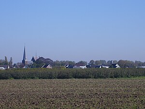
Zevenaar
City and municipality in Gelderland, Netherlands
Distance: Approx. 717 meters
Latitude and longitude: 51.91666667,6.06666667
Zevenaar (Dutch pronunciation: [ˈzeːvənaːr] ) is a municipality and a city in the Gelderland province, in the eastern Netherlands near the border with Germany. In January 2018 the neighbouring municipality of Rijnwaarden was merged with Zevenaar.
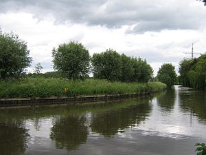
Oude Rijn (Gelderland)
Distance: Approx. 3142 meters
Latitude and longitude: 51.896,6.089
Oude Rijn ("Old Rhine"; not to be confused with the Alter Rhein) is the name of a long former bend in river Rhine in the Dutch province of Gelderland. In summer the bend became too shallow to be navigable, and so between 1701 and 1709 it was cut off from the main waterway near the town of Lobith and replaced by the Pannerdens Kanaal. After the bend was dammed-up at Tolkamer, the Oude Rijn received little water from the Rhine proper.
Helhoek, Gelderland
Hamlet in Gelderland, Netherlands
Distance: Approx. 2523 meters
Latitude and longitude: 51.935,6.04166667
Helhoek is a hamlet in the Dutch province of Gelderland. It is located in the municipality of Duiven, between the towns of Duiven and Zevenaar. It was first mentioned between 1830 and 1855 as Helhoek.

Aerdt
Village in Gelderland, Netherlands
Distance: Approx. 3311 meters
Latitude and longitude: 51.89333333,6.08361111
Aerdt is a village in the Dutch province of Gelderland. It is in the municipality of Zevenaar, about 20 km northeast of the city of Nijmegen, close to the German border. Until it became part of Rijnwaarden in 1985, Aerdt and neighbouring village Herwen constituted a separate municipality Herwen en Aerdt.

Babberich
Village in Gelderland, Netherlands
Distance: Approx. 3228 meters
Latitude and longitude: 51.90611111,6.11111111
Babberich is a village in the Dutch province of Gelderland. It is in the municipality Zevenaar, about 3 km southeast of the centre of Zevenaar. It's located near the border with Germany.

Zevenaar railway station
Railway station located in Zevenaar, Netherlands
Distance: Approx. 109 meters
Latitude and longitude: 51.92305556,6.07277778
Zevenaar is a railway station located in Zevenaar, Netherlands. The station was opened on 15 February 1856 and is located on the Winterswijk–Zevenaar railway and the Oberhausen–Arnhem railway. There used to be a connection to Kleve (Germany) as well (from 1865-1914).

De Buitenmolen, Zevenaar
Tower mill in Zevenaar, Netherlands
Distance: Approx. 573 meters
Latitude and longitude: 51.925411,6.06547
The Buitenmolen (Outer mill) is a tower mill in Zevenaar, Netherlands that was restored to working order in 1970. The mill was built in the beginning of the sixteenth century and is listed as a Rijksmonument, number 40427.

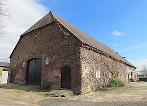
Huize Sevenaer
Castle farm in Zevenaar, the Netherlands
Distance: Approx. 653 meters
Latitude and longitude: 51.9269,6.0777
Huize Sevenaer (Huis Sevenaer, Huize Zevenaar or Huis Seventer) is a castle farm in Zevenaar, the Netherlands. The estate has existed since the 14th century and since 1947 has been the last remaining fully operational castle farm in the country, and one of the few remaining in Europe. The castle has been private property of the van Nispen family since 1785, and is owned and operated by Jonkheer Huub van Nispen van Sevenaer.

Brick Works De Panoven
Dutch brick museum
Distance: Approx. 523 meters
Latitude and longitude: 51.9185,6.0673
The Brick Works De Panoven is a brick museum in Zevenaar, the Gelderland, the Netherlands. The museum is an Anchor point on the European Route of Industrial Heritage. It is also a rijksmonument (number 338309).
Groessen
Village in Gelderland, Netherlands
Distance: Approx. 3284 meters
Latitude and longitude: 51.9305,6.0261
Groessen is a village in the municipality of Duiven in the province of Gelderland, the Netherlands. It was first mentioned in 838 in uilla Gruosna, and means "settlement in grassland". The village developed near the Rhine.

Oud-Zevenaar
Village in Gelderland, Netherlands
Distance: Approx. 1042 meters
Latitude and longitude: 51.9149,6.0815
Oud-Zevenaar (Dutch pronunciation: [ˌʌutˈseːvənaːr]) is a village in the municipality of Zevenaar in the province of Gelderland, the Netherlands. It is located to the south of Zevenaar The village was first mentioned in 1047 as Subenhara. The etymology is unclear.

De Hoop, Oud-Zevenaar
Dutch windmill
Distance: Approx. 1735 meters
Latitude and longitude: 51.915831,6.095058
De Hoop is a gristmill in Oud-Zevenaar, Netherlands. It was owned by the Pijnappel family from 1852 until 2014, at which point it was sold to the Botter family. The current miller is Frits Botter.
Weather in this IP's area
overcast clouds
20 Celsius
21 Celsius
19 Celsius
21 Celsius
1009 hPa
88 %
1009 hPa
1008 hPa
10000 meters
3.85 m/s
10.37 m/s
224 degree
100 %
06:59:36
20:07:22