91.229.86.31 - IP Lookup: Free IP Address Lookup, Postal Code Lookup, IP Location Lookup, IP ASN, Public IP
Country:
Region:
City:
Location:
Time Zone:
Postal Code:
ISP:
ASN:
language:
User-Agent:
Proxy IP:
Blacklist:
IP information under different IP Channel
ip-api
Country
Region
City
ASN
Time Zone
ISP
Blacklist
Proxy
Latitude
Longitude
Postal
Route
db-ip
Country
Region
City
ASN
Time Zone
ISP
Blacklist
Proxy
Latitude
Longitude
Postal
Route
IPinfo
Country
Region
City
ASN
Time Zone
ISP
Blacklist
Proxy
Latitude
Longitude
Postal
Route
IP2Location
91.229.86.31Country
Region
podlaskie
City
augustow
Time Zone
Europe/Warsaw
ISP
Language
User-Agent
Latitude
Longitude
Postal
ipdata
Country
Region
City
ASN
Time Zone
ISP
Blacklist
Proxy
Latitude
Longitude
Postal
Route
Popular places and events near this IP address

Augustów
Town in Podlaskie Voivodeship, Poland
Distance: Approx. 51 meters
Latitude and longitude: 53.84361111,22.97944444
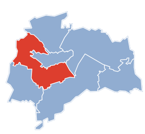
Augustów ([au̯ˈɡustuf] formerly known in English as Augustovo or Augustowo) is a town in north-eastern Poland. It lies on the Netta River and the Augustów Canal. It is the seat of Augustów County and of Gmina Augustów in the Podlaskie Voivodeship.

Augustów County
County in Podlaskie Voivodeship, Poland
Distance: Approx. 1148 meters
Latitude and longitude: 53.85,22.96666667
Augustów County (Polish: powiat augustowski) is a unit of territorial administration and local government (powiat) in Podlaskie Voivodeship, north-eastern Poland, on the border with Belarus. It came into being on 1 January 1999 as a result of the Polish local government reforms passed in 1998. Its administrative seat and largest city is Augustów, which lies 83 kilometres (52 mi) north of the regional capital Białystok.
Augustów Canal
Canal in Poland
Distance: Approx. 2751 meters
Latitude and longitude: 53.86666667,22.96666667
The Augustów Canal (Polish: Kanał Augustowski, [ˈkanau̯ au̯ɡusˈtɔfski], Belarusian: Аўгустоўскі канал, romanized: Aŭhustoŭski kanal) is a cross-border canal built by the Congress Kingdom of Poland in 19th century in the Augustów Voivodeship (present-day Podlaskie Voivodeship of northeastern Poland and Grodno Oblast of western Belarus). From the time it was first built, the canal was described by experts as a technological marvel, with numerous sluices contributing to its aesthetic appeal. It was the first summit level canal in Central Europe to provide a direct link between the two major rivers, Vistula River through the Biebrza River – a tributary of the Narew River, and the Neman River through its tributary – the Czarna Hańcza River, and it provided a link with the Black Sea to the south through the Oginski Canal, Daugava River, Berezina Canal and Dnieper River.

Gmina Augustów
Gmina in Podlaskie Voivodeship, Poland
Distance: Approx. 1148 meters
Latitude and longitude: 53.85,22.96666667
Gmina Augustów is a rural gmina (administrative district) in Augustów County, Podlaskie Voivodeship, in north-eastern Poland. Its seat is the town of Augustów, although the town is not part of the territory of the gmina. The gmina covers an area of 266.52 square kilometres (102.9 sq mi), and as of 2019 its population is 6,764.
Białobrzegi, Podlaskie Voivodeship
Village in Podlaskie Voivodeship, Poland
Distance: Approx. 4587 meters
Latitude and longitude: 53.8025,22.96888889
Białobrzegi [bʲawɔˈbʐɛɡʲi] is a village in the administrative district of Gmina Augustów, within Augustów County, Podlaskie Voivodeship, in north-eastern Poland. It lies approximately 6 kilometres (4 mi) south of Augustów and 78 km (48 mi) north of the regional capital Białystok.
Czarnucha
Village in Podlaskie Voivodeship, Poland
Distance: Approx. 5477 meters
Latitude and longitude: 53.81666667,23.05
Czarnucha [t͡ʂarˈnuxa] is a village in the administrative district of Gmina Augustów, within Augustów County, Podlaskie Voivodeship, in north-eastern Poland. It lies approximately 7 kilometres (4 mi) south-east of Augustów and 79 km (49 mi) north of the regional capital Białystok.
Ponizie
Village in Podlaskie Voivodeship, Poland
Distance: Approx. 5385 meters
Latitude and longitude: 53.8,23.01666667
Ponizie [pɔˈɲiʑɛ] is a village in the administrative district of Gmina Augustów, within Augustów County, Podlaskie Voivodeship, in northeastern Poland. It lies approximately 7 kilometres (4 mi) south-east of Augustów and 77 km (48 mi) north of the regional capital Białystok.
Żarnowo Pierwsze
Village in Podlaskie Voivodeship, Poland
Distance: Approx. 5555 meters
Latitude and longitude: 53.81194444,22.91388889
Żarnowo Pierwsze [ʐarˈnɔvɔ ˈpʲɛrfʂɛ] is a village in the administrative district of Gmina Augustów, within Augustów County, Podlaskie Voivodeship, in north-eastern Poland.
Białobrzegi Lock
Distance: Approx. 4098 meters
Latitude and longitude: 53.806976,22.968698
Białobrzegi Lock - the fourth lock on the Augustów Canal (from the Biebrza River). Located in the village of Białobrzegi in the administrative district of Gmina Augustów, within Augustów County, Podlaskie Voivodeship, in north-eastern Poland. It lies approximately 6 kilometres (4 mi) south of Augustów and 78 km (48 mi) north of the regional capital Białystok.
Augustów Lock
Distance: Approx. 760 meters
Latitude and longitude: 53.841365,22.990948
Augustów Lock – the fifth lock on the Augustów Canal (from the Biebrza River). It is located in Augustów, Poland near National Road No 8 and built between 1825 and 1826 by cf Eng. Konstanty Jodko It was blown up in 1944 by an army of the Third Reich and rebuilt in its present form by "HYDROTREST" in the years 1947–1948 Under a new projectit will use of metal gates with channels of circulation and the gate mechanisms for opening the gates i driven by cranks.

Bystry Canal
Distance: Approx. 2751 meters
Latitude and longitude: 53.86666667,22.96666667
The Bystry Canal (Polish: Kanał Bystry, [ˈkanau̯ bɨstrɨ]), is a feeder canal for the Augustów Canal which was built during the 19th century in the present-day Podlaskie Voivodeship of northeastern Poland (then the Augustów Voivodeship of the Kingdom of Poland).
Białe Augustowskie (lake)
Ribbon lake in Poland
Distance: Approx. 4159 meters
Latitude and longitude: 53.86416667,23.03222222
Białe Augustowskie (Polish: Jezioro Białe Augustowskie; Lithuanian: Baltis) - is a ribbon lake in Augustów. Other names: Białe Lake (White Lake) or Krechowieckie Lake. The lake has an area of about 480 ha (1,200 acres).
Weather in this IP's area
broken clouds
-0 Celsius
-3 Celsius
-0 Celsius
-0 Celsius
1015 hPa
92 %
1015 hPa
999 hPa
10000 meters
1.93 m/s
3.38 m/s
195 degree
54 %


