91.229.85.117 - IP Lookup: Free IP Address Lookup, Postal Code Lookup, IP Location Lookup, IP ASN, Public IP
Country:
Region:
City:
Location:
Time Zone:
Postal Code:
ISP:
ASN:
language:
User-Agent:
Proxy IP:
Blacklist:
IP information under different IP Channel
ip-api
Country
Region
City
ASN
Time Zone
ISP
Blacklist
Proxy
Latitude
Longitude
Postal
Route
db-ip
Country
Region
City
ASN
Time Zone
ISP
Blacklist
Proxy
Latitude
Longitude
Postal
Route
IPinfo
Country
Region
City
ASN
Time Zone
ISP
Blacklist
Proxy
Latitude
Longitude
Postal
Route
IP2Location
91.229.85.117Country
Region
podlaskie
City
suwalki
Time Zone
Europe/Warsaw
ISP
Language
User-Agent
Latitude
Longitude
Postal
ipdata
Country
Region
City
ASN
Time Zone
ISP
Blacklist
Proxy
Latitude
Longitude
Postal
Route
Popular places and events near this IP address

Suwałki Voivodeship
Voivodeship of Poland (1975–1998)
Distance: Approx. 3173 meters
Latitude and longitude: 54.08333333,22.93333333
Suwałki Voivodeship (Polish: województwo suwalskie) was an administrative division and local government in Poland from 1975 to 1998. In 1999 the Voidvodeship was divided in half and reassigned to two other Voivodeships – the eastern half to Podlaskie Voivodeship and the western half to Warmian-Masurian Voivodeship. Its capital city was Suwałki.

Suwałki
City in Podlaskie Voivodeship, Poland
Distance: Approx. 1445 meters
Latitude and longitude: 54.09888889,22.92861111
Suwałki ([suˈvau̯kʲi] ; Lithuanian: Suvalkai; Yiddish: סואוואַלק or סוּוואַלק) is a city in northeastern Poland with a population of 69,206 (2021). It is the capital of Suwałki County and one of the most important centers of commerce in the Podlaskie Voivodeship. Suwałki is the largest city and the capital of the historical Suwałki Region.

Suwałki Region
Historical region in Poland
Distance: Approx. 1323 meters
Latitude and longitude: 54.1,22.933333
Suwałki Region (Polish: Suwalszczyzna[a] [suvalʂt͡ʂɨzna] ; Lithuanian: Suvalkų kraštas, Suvalkija) is a historical region around the city of Suwałki in northeastern Poland near the border with Lithuania. It encompasses the powiats of Augustów, Suwałki, and Sejny, and roughly corresponds to the southern part of the former Suwałki Governorate. The region was disputed between Poland and Lithuania after their re-emergence as independent states following World War I. This dispute along with the Vilnius question was the cause of the Polish-Lithuanian War and the Sejny Uprising.

Suwałki County
County in Podlaskie Voivodeship, Poland
Distance: Approx. 3173 meters
Latitude and longitude: 54.08333333,22.93333333
Suwałki County (Polish: powiat suwalski) is a unit of territorial administration and local government (powiat) in Podlaskie Voivodeship, north-eastern Poland, on the Lithuanian border. It came into being on January 1, 1999, as a result of the Polish local government reforms passed in 1998. Its administrative seat is the city of Suwałki, although the city is not part of the county (it constitutes a separate city county); there are no towns within the county.

Gmina Suwałki
Gmina in Podlaskie Voivodeship, Poland
Distance: Approx. 3173 meters
Latitude and longitude: 54.08333333,22.93333333
Gmina Suwałki is a rural gmina (administrative district) in Suwałki County, Podlaskie Voivodeship, in north-eastern Poland. Its seat is the town of Suwałki, although the town is not part of the territory of the gmina. The gmina covers an area of 264.82 square kilometres (102.2 sq mi), and as of 2006 its total population is 6,388.
Okuniowiec
Village in Podlaskie Voivodeship, Poland
Distance: Approx. 3464 meters
Latitude and longitude: 54.11666667,22.98333333
Okuniowiec [ɔkuˈɲɔvjɛt͡s] is a village in the administrative district of Gmina Suwałki, within Suwałki County, Podlaskie Voivodeship, in north-eastern Poland. It lies approximately 5 kilometres (3 mi) north-east of Suwałki and 112 km (70 mi) north of the regional capital Białystok.
Osinki, Suwałki County
Village in Podlaskie Voivodeship, Poland
Distance: Approx. 3464 meters
Latitude and longitude: 54.11666667,22.98333333
Osinki [ɔˈɕiŋki] is a village in the administrative district of Gmina Suwałki, within Suwałki County, Podlaskie Voivodeship, in north-eastern Poland. It lies approximately 5 kilometres (3 mi) north-east of Suwałki and 112 km (70 mi) north of the regional capital Białystok.
Zielone Kamedulskie
Village in Podlaskie Voivodeship, Poland
Distance: Approx. 3756 meters
Latitude and longitude: 54.08333333,22.9
Zielone Kamedulskie (Polish pronunciation: [ʑɛˈlɔnɛ kamɛˈdulskʲɛ]) is a village in the administrative district of Gmina Suwałki, within Suwałki County, Podlaskie Voivodeship, in north-eastern Poland. It lies approximately 3 kilometres (2 mi) west of Suwałki and 109 km (68 mi) north of the regional capital Białystok.

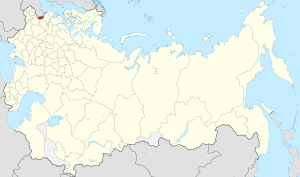
Suwałki Governorate
1867–1914 unit of Poland
Distance: Approx. 3173 meters
Latitude and longitude: 54.08333333,22.93333333
Suwałki Governorate was an administrative-territorial unit (guberniya) of Congress Poland of the Russian Empire, which had its seat in the city of Suwałki. It covered a territory of about 12,300 square kilometres (4,700 sq mi).

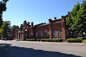
Suwałki railway station
Railway station in Suwałki, Poland
Distance: Approx. 934 meters
Latitude and longitude: 54.10666667,22.94222222
Suwałki railway station is a railway station in Suwałki, Poland. As of 2012, it is served by Przewozy Regionalne (local services) and international trains to and from Lithuania. In 2017, the station served 300–499 passengers per day.
Szwajcaria, Podlaskie Voivodeship
Place in Podlaskie Voivodeship, Poland
Distance: Approx. 3391 meters
Latitude and longitude: 54.1386,22.9556
Szwajcaria [szvajt͡saria] is a former village in the administrative district of Gmina Suwałki, within Suwałki County, Podlaskie Voivodeship, in north-eastern Poland. In 1981 it was incorporated into the city of Suwałki.
Roman Catholic parish cemetery in Suwałki
Cemetery in Suwałki, Poland
Distance: Approx. 1982 meters
Latitude and longitude: 54.09694444,22.91416667
The Roman Catholic parish cemetery in Suwałki is the cemetery serving the Roman Catholic community of Suwałki. The necropolis belongs to the Co-Cathedral Parish of St. Alexander and is located on Zarzecze Street in the western part of the city.
Weather in this IP's area
overcast clouds
1 Celsius
1 Celsius
1 Celsius
1 Celsius
1016 hPa
93 %
1016 hPa
994 hPa
10000 meters
1.25 m/s
1.2 m/s
5 degree
100 %
