91.229.39.47 - IP Lookup: Free IP Address Lookup, Postal Code Lookup, IP Location Lookup, IP ASN, Public IP
Country:
Region:
City:
Location:
Time Zone:
Postal Code:
ISP:
ASN:
language:
User-Agent:
Proxy IP:
Blacklist:
IP information under different IP Channel
ip-api
Country
Region
City
ASN
Time Zone
ISP
Blacklist
Proxy
Latitude
Longitude
Postal
Route
db-ip
Country
Region
City
ASN
Time Zone
ISP
Blacklist
Proxy
Latitude
Longitude
Postal
Route
IPinfo
Country
Region
City
ASN
Time Zone
ISP
Blacklist
Proxy
Latitude
Longitude
Postal
Route
IP2Location
91.229.39.47Country
Region
zilinsky kraj
City
liptovsky mikulas
Time Zone
Europe/Bratislava
ISP
Language
User-Agent
Latitude
Longitude
Postal
ipdata
Country
Region
City
ASN
Time Zone
ISP
Blacklist
Proxy
Latitude
Longitude
Postal
Route
Popular places and events near this IP address

Liptó County
County of the Kingdom of Hungary
Distance: Approx. 505 meters
Latitude and longitude: 49.08333333,19.61666667
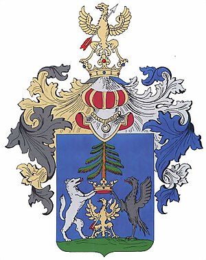
Liptó County (Hungarian: Liptó vármegye, Latin: Comitatus Liptoviensis, Slovak: Liptovská župa, German: Komitat Liptau, Polish: Komitat Liptów) was an administrative county (comitatus) of the Kingdom of Hungary. Its territory is now in northern Slovakia.

Liptovský Mikuláš
Town in Slovakia
Distance: Approx. 1510 meters
Latitude and longitude: 49.08416667,19.60222222
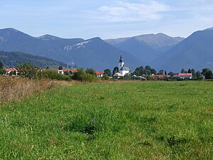
Liptovský Mikuláš (Slovak pronunciation: [ˈliptɔwskiː ˈmikulaːʂ] ; until 1952 Liptovský Svätý Mikuláš, German: Liptau-Sankt-Nikolaus; Hungarian: Liptószentmiklós) is a town in northern Slovakia, on the Váh River, about 285 kilometers (177 mi) from Bratislava. It lies in the Liptov region, in Liptov Basin near the Low Tatra and Tatra mountains. The town, known as Liptovský Svätý Mikuláš (or Liptovský Saint Nicholas) before communist times, is also renowned as a town of guilds and culture.
Liptovský Mikuláš District
District in Žilina Region, Slovakia
Distance: Approx. 5 meters
Latitude and longitude: 49.08055556,19.62222222
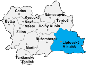
Liptovský Mikuláš District (okres Liptovský Mikuláš) is a district in the eastern part of Žilina Region of central Slovakia. The district was established in the 19th century with its current name and exists within current borders since 1996. Its main cultural and economic center is its seat Liptovský Mikuláš.
Liptovský Mikuláš Ice Stadium
Distance: Approx. 890 meters
Latitude and longitude: 49.08055556,19.61
Zimný štadión Liptovský Mikuláš (Liptovský Mikuláš Winter Sports Stadium) is an arena in Liptovský Mikuláš, Slovakia. It is primarily used for ice hockey, and it is the home arena of MHk 32 Liptovský Mikuláš. It was opened in 1949 and holds 3,680 people.

Bobrovec
Distance: Approx. 4035 meters
Latitude and longitude: 49.11666667,19.61666667
Bobrovec (Hungarian: Nagybobróc) is a village and municipality in Liptovský Mikuláš District in the Žilina Region of northern Slovakia.

Trstené
Distance: Approx. 4035 meters
Latitude and longitude: 49.11666667,19.61666667
Trstené (Hungarian: Nádasd) is a village and municipality in Liptovský Mikuláš District in the Žilina Region of northern Slovakia.

Závažná Poruba
Distance: Approx. 2553 meters
Latitude and longitude: 49.06666667,19.65
Závažná Poruba (Hungarian: Németporuba) is a village and municipality in Liptovský Mikuláš District in the Žilina Region of northern Slovakia.

Liptov
County of the Kingdom of Hungary
Distance: Approx. 0 meters
Latitude and longitude: 49.0806,19.6222
Liptov (Slovak pronunciation: [ˈliptɔw]) is a historical and geographical region in central Slovakia with around 140,000 inhabitants. The area is also known by the German name Liptau, the Hungarian Liptó, the Latin name Liptovium and the Polish Liptów.
Stadium Liptovský Mikuláš
Football stadium in Liptovský Mikuláš, Slovakia
Distance: Approx. 1996 meters
Latitude and longitude: 49.0775,19.64916667
Stadium Liptovský Mikuláš is a home football stadium in Liptovský Mikuláš, Slovakia. It serves as home stadium for football club MFK Tatran Liptovský Mikuláš. The stadium has a capacity of 1,950 (610 seats).

Ondrej Cibak Whitewater Slalom Course
Distance: Approx. 824 meters
Latitude and longitude: 49.0735,19.619
The Ondrej Cibak Whitewater Slalom Course, in Liptovský Mikuláš, Slovakia, is the world's second-oldest artificial whitewater venue for international canoe slalom competition, after the Augsburg Eiskanal. Built in 1978, it diverts water around a small dam on the Váh river. With recent upgrades, including a covered stadium for spectators, it remains a prime site for the sport.
Ploštín
Distance: Approx. 2960 meters
Latitude and longitude: 49.05611111,19.60638889
Ploštín (Hungarian: Plostin) is a settlement and a borough of Liptovský Mikuláš in northern Slovakia, located 3 km south of the city center. In 2009, Ploštín had a population of 481.
Armed Forces Academy of General Milan Rastislav Štefánik
Military Academy in Liptovský Mikuláš, Slovakia
Distance: Approx. 2737 meters
Latitude and longitude: 49.066,19.592
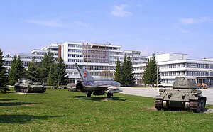
The Armed Forces Academy of General Milan Rastislav Štefánik, located in Liptovský Mikuláš, is Slovakia's only Military academy. It was originally established in 1945, right after the end of World War II, first as a High School and from 1973 as a university. AOS has about 500 students, including 50 PhD students.
Weather in this IP's area
clear sky
1 Celsius
-2 Celsius
1 Celsius
1 Celsius
1028 hPa
88 %
1028 hPa
911 hPa
10000 meters
2.34 m/s
1.69 m/s
144 degree
1 %
