Country:
 Poland
Region:
City:
Latitude and Longitude:
Time Zone:
Postal Code:
IP information under different IP Channel
ip-api
Country
Region
City
ASN
Time Zone
ISP
Blacklist
Proxy
Latitude
Longitude
Postal
Route
IPinfo
Country
Region
City
ASN
Time Zone
ISP
Blacklist
Proxy
Latitude
Longitude
Postal
Route
MaxMind
Country
Region
City
ASN
Time Zone
ISP
Blacklist
Proxy
Latitude
Longitude
Postal
Route
Luminati
Country
PLASN
Time Zone
Europe/Warsaw
ISP
Voxel S.A.
Latitude
Longitude
Postal
db-ip
Country
Region
City
ASN
Time Zone
ISP
Blacklist
Proxy
Latitude
Longitude
Postal
Route
ipdata
Country
Region
City
ASN
Time Zone
ISP
Blacklist
Proxy
Latitude
Longitude
Postal
Route
Popular places and events near this IP address
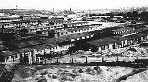
Kraków-Płaszów concentration camp
Nazi concentration camp in Poland
Distance: Approx. 3382 meters
Latitude and longitude: 50.03083333,19.9675
Płaszów (Polish pronunciation: [ˈpwaʂuf]) or Kraków-Płaszów was a Nazi concentration camp operated by the SS in Płaszów, a southern suburb of Kraków, in the General Governorate of German-occupied Poland. Most of the prisoners were Polish Jews who were targeted for destruction by Nazi Germany during the Holocaust. Many prisoners died because of executions, forced labor, and the poor conditions in the camp.

Podgórze
District of Kraków, Poland
Distance: Approx. 3662 meters
Latitude and longitude: 50.04166667,19.98333333
Podgórze (German: Josefstadt) is a district of Kraków, Poland, situated on the right (southern) bank of the Vistula River, at the foot of Lasota Hill. The district was subdivided in 1990 into six new districts, see present-day districts of Kraków for more details. The name Podgórze roughly translates as the base of a hill.

Podgórze Duchackie
Dzielnica of Kraków in Lesser Poland Voivodeship, Poland
Distance: Approx. 2865 meters
Latitude and longitude: 50.01227778,19.96406944
Podgórze Duchackie is one of 18 districts of Kraków, located in the southern part of the city. The name Podgórze Duchackie comes from two villages that are now parts of the district. According to the Central Statistical Office data, the district's area is 9.54 square kilometres (3.68 square miles) and 52 859 people inhabit Podgórze Duchackie.
Bieżanów-Prokocim
Dzielnica of Kraków in Lesser Poland Voivodeship, Poland
Distance: Approx. 2006 meters
Latitude and longitude: 50.01632778,20.03116111
Bieżanów-Prokocim is one of 18 districts of Kraków, located in the southeast part of the city. The name Bieżanów-Prokocim comes from two villages that are now parts of the district. According to the Central Statistical Office data, the district's area is 18.47 square kilometres (7.13 square miles) and 63 029 people inhabit Bieżanów-Prokocim at the density of 3,413 people per square kilometre (8,840 people/sq mi).

Krakus Mound
Prehistoric tumulus in Kraków, Poland
Distance: Approx. 4424 meters
Latitude and longitude: 50.03833333,19.95833333
Krakus Mound or Kopiec Krakusa in Polish, also called the Krak Mound, is a tumulus located in the Podgórze district of Kraków, Poland; thought to be the resting place of Kraków's mythical founder, the legendary King Krakus. It is located on Lasota Hill, approximately 3 kilometres (2 mi) south of Kraków's city centre, at an altitude of 271 metres (889 ft), with a base diameter of 60 metres (197 ft) and a height of 16 metres (52 ft). Together with nearby Wanda Mound, it is one of Kraków's two prehistoric mounds as well as the oldest man-made structure in Kraków.
Czarnochowice
Village in Lesser Poland Voivodeship, Poland
Distance: Approx. 4659 meters
Latitude and longitude: 50,20.06666667
Czarnochowice [t͡ʂarnɔxɔˈvit͡sɛ] is a village in the administrative district of Gmina Wieliczka, within Wieliczka County, Lesser Poland Voivodeship, in southern Poland. It lies approximately 2 kilometres (1 mi) north of Wieliczka and 12 km (7 mi) south-east of the regional capital Kraków.
Grabówki, Lesser Poland Voivodeship
Village in Lesser Poland Voivodeship, Poland
Distance: Approx. 4628 meters
Latitude and longitude: 49.97305556,20.02833333
Grabówki [ɡraˈbufki] is a village in the administrative district of Gmina Wieliczka, within Wieliczka County, Lesser Poland Voivodeship, in southern Poland. It lies approximately 4 kilometres (2 mi) south-west of Wieliczka and 12 km (7 mi) south-east of the regional capital Kraków.
Siercza
Village in Lesser Poland Voivodeship, Poland
Distance: Approx. 4549 meters
Latitude and longitude: 49.98333333,20.05
Siercza [ˈɕɛrt͡ʂa] is a village in the administrative district of Gmina Wieliczka, within Wieliczka County, Lesser Poland Voivodeship, in southern Poland. It lies approximately 2 kilometres (1 mi) south-west of Wieliczka and 12 km (7 mi) south-east of the regional capital Kraków.

Hujowa Górka
Place in Poland, related to Holocaust
Distance: Approx. 3453 meters
Latitude and longitude: 50.03027778,19.96555556
Hujowa Górka ([xuˈjɔ.va ˈɡurka]; sometimes ”Hujarowa Górka” or Chujowa Górka, rarely ”Kozia Górka”) is a place near the site of Kraków-Płaszów concentration camp, where in April 1944 the Nazis exhumed and incinerated the bodies of around ten thousand previously killed Jews, to hide the evidence of the crime before retreating from the area. The place took its name from the surname of Unterscharführer Albert Hujar (also Huyar) who committed and directed the executions. It is also a mockery of Hujar's surname, which is pronounced similarly to a vulgar Polish language expression for "penis" (its English equivalent is "prick"), hence the name is Polish for "Prick Hill", because it could be seen from almost any part of the camp.

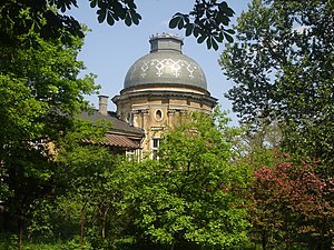
Divine Mercy Sanctuary, Kraków
Church building in Kraków, Poland
Distance: Approx. 4855 meters
Latitude and longitude: 50.02,19.9375
The Divine Mercy Sanctuary (Polish: Sanktuarium Bożego Miłosierdzia) in Kraków, Poland, is a Roman Catholic basilica dedicated to the devotion of the Divine Mercy, and is the resting place of Saint Faustina Kowalska. The new basilica was built between 1999 and 2002, and is located in the District of Łagiewniki at św. Faustyny street.

Swoszowice, Kraków
Dzielnica of Kraków in Lesser Poland Voivodeship, Poland
Distance: Approx. 4394 meters
Latitude and longitude: 49.98637778,19.95686944
Swoszowice is one of 18 districts of Kraków, located in the southern part of the city. The name Swoszowice comes from a village of same name that is now a part of the district. According to the Central Statistical Office data, the district's area is 25.6 square kilometres (9.88 square miles) and 25 608 people inhabit Swoszowice.

Kraków Płaszów railway station
Railway station in Kraków, Poland
Distance: Approx. 3434 meters
Latitude and longitude: 50.03473,19.9723325
Kraków Płaszów railway station is a railway station in Płaszów, a suburb of Kraków (Lesser Poland), Poland. As of 2022, it is served by Koleje Małopolskie (KMŁ),Polregio, and PKP Intercity (EIP, InterCity, and TLK services). The station is located near Kraków-Płaszów concentration camp.
Weather in this IP's area
moderate rain
12 Celsius
12 Celsius
11 Celsius
13 Celsius
1007 hPa
88 %
1007 hPa
979 hPa
4500 meters
1.54 m/s
220 degree
75 %
06:55:41
17:57:18