Country:
 Switzerland
Region:
City:
Latitude and Longitude:
Time Zone:
Postal Code:
IP information under different IP Channel
ip-api
Country
Region
City
ASN
Time Zone
ISP
Blacklist
Proxy
Latitude
Longitude
Postal
Route
IPinfo
Country
Region
City
ASN
Time Zone
ISP
Blacklist
Proxy
Latitude
Longitude
Postal
Route
MaxMind
Country
Region
City
ASN
Time Zone
ISP
Blacklist
Proxy
Latitude
Longitude
Postal
Route
Luminati
Country
CHASN
Time Zone
Europe/Zurich
ISP
Init7 (Switzerland) Ltd.
Latitude
Longitude
Postal
db-ip
Country
Region
City
ASN
Time Zone
ISP
Blacklist
Proxy
Latitude
Longitude
Postal
Route
ipdata
Country
Region
City
ASN
Time Zone
ISP
Blacklist
Proxy
Latitude
Longitude
Postal
Route
Popular places and events near this IP address

Wiesendangen
Municipality in Zürich, Switzerland
Distance: Approx. 732 meters
Latitude and longitude: 47.51666667,8.78333333
Wiesendangen is a municipality in the district of Winterthur in the canton of Zürich in Switzerland. On 1 January 2014 the former municipality of Bertschikon merged into the municipality of Wiesendangen. At the same time the Community Identification Number changed from 0229 to 0298.

Oberwinterthur
District in Zürich, Switzerland
Distance: Approx. 1489 meters
Latitude and longitude: 47.517,8.769
Oberwinterthur is a district in the Swiss city of Winterthur. It is district number 2. The district comprises the quarters Talacker, Guggenbühl, Zinzikon, Reutlingen, Stadel, Grüze, Hegmatten and Hegi.

Guggenbühl
Distance: Approx. 2295 meters
Latitude and longitude: 47.513,8.76
Guggenbühl is a quarter in the district 2 of Winterthur. It was formerly a part of Oberwinterthur municipality, which was incorporated into Winterthur in 1922.

Hegi
Distance: Approx. 2407 meters
Latitude and longitude: 47.503,8.774
Hegi is a quarter in the district 2 of Winterthur. It was formerly a part of Oberwinterthur municipality, which was incorporated into Winterthur in 1922.

Zinzikon
Distance: Approx. 2495 meters
Latitude and longitude: 47.5178,8.7545
Zinzikon is a quarter in the district 2 of Winterthur. It was formerly a part of Oberwinterthur municipality, which was incorporated into Winterthur in 1922.

Stadel (Winterthur)
Distance: Approx. 2294 meters
Latitude and longitude: 47.53416667,8.76138889
Stadel is a quarter in the district 2 of Winterthur. It was formerly a part of Oberwinterthur municipality, which was incorporated into Winterthur in 1922.

Hegmatten
Distance: Approx. 1501 meters
Latitude and longitude: 47.51527778,8.77027778
Hegmatten is a quarter in the district 2 of Winterthur. It was formerly a part of Oberwinterthur municipality, which was incorporated into Winterthur in 1922.

Hegi Castle
Distance: Approx. 1994 meters
Latitude and longitude: 47.50824,8.771393
Hegi Castle (German: Schloss Hegi) is a castle in the city of Winterthur of the canton of Zurich in Switzerland. It is a Swiss heritage site of national significance.
Wiesendangen railway station
Railway station in Wiesendangen, Switzerland
Distance: Approx. 862 meters
Latitude and longitude: 47.525616,8.776172
Wiesendangen is a railway station in the Swiss canton of Zurich and municipality of Wiesendangen. The station is located on the Winterthur–Romanshorn railway line. It is an intermediate stop on Zurich S-Bahn services S24 and S30.
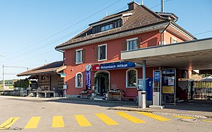
Rickenbach-Attikon railway station
Railway station in Thurgau, Switzerland
Distance: Approx. 1384 meters
Latitude and longitude: 47.535124,8.789309
Rickenbach-Attikon is a railway station in the Swiss canton of Zurich and municipality of Rickenbach. It takes its name from that municipality, and the adjacent village of Attikon, in the municipality of Wiesendangen. The station is located on the Winterthur–Romanshorn railway line.
Winterthur Wallrüti railway station
Railway station in Canton of Zürich, Switzerland
Distance: Approx. 2062 meters
Latitude and longitude: 47.516672,8.760969
Winterthur Wallrüti railway station is a railway station in the Swiss canton of Zurich and city of Winterthur. The station is on the Winterthur to Etzwilen line.
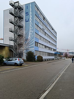
International School Winterthur
Defunct school in Winterthur, Switzerland
Distance: Approx. 2389 meters
Latitude and longitude: 47.5069,8.7655
International School Winterthur (ISW) was an international school in Winterthur, Switzerland, serving ages 3 through 18. It was established in 2001, but closed suddenly on 22 May 2015 after declaring insolvency. ISW's Kindergarten and primary education programs (Primary Years Programms and part of Middle Years Programm) were approved by the bureau for elementary school (Volksschulamt), administration for education (Bildungsdirektion), canton of Zurich.
Weather in this IP's area
light rain
19 Celsius
19 Celsius
19 Celsius
22 Celsius
1011 hPa
74 %
1011 hPa
958 hPa
10000 meters
2.06 m/s
300 degree
75 %
06:53:20
19:51:55