91.228.242.216 - IP Lookup: Free IP Address Lookup, Postal Code Lookup, IP Location Lookup, IP ASN, Public IP
Country:
Region:
City:
Location:
Time Zone:
Postal Code:
ISP:
ASN:
language:
User-Agent:
Proxy IP:
Blacklist:
IP information under different IP Channel
ip-api
Country
Region
City
ASN
Time Zone
ISP
Blacklist
Proxy
Latitude
Longitude
Postal
Route
db-ip
Country
Region
City
ASN
Time Zone
ISP
Blacklist
Proxy
Latitude
Longitude
Postal
Route
IPinfo
Country
Region
City
ASN
Time Zone
ISP
Blacklist
Proxy
Latitude
Longitude
Postal
Route
IP2Location
91.228.242.216Country
Region
england
City
blackwall
Time Zone
Europe/London
ISP
Language
User-Agent
Latitude
Longitude
Postal
ipdata
Country
Region
City
ASN
Time Zone
ISP
Blacklist
Proxy
Latitude
Longitude
Postal
Route
Popular places and events near this IP address

London Internet Exchange
Internet exchange point in London
Distance: Approx. 232 meters
Latitude and longitude: 51.511453,-0.003418
The London Internet Exchange (LINX) is a mutually governed Internet exchange point (IXP) providing peering services and public policy representation to network operators, encompassing over 950 different autonomous systems (ASNs). Established in 1994 in London, LINX operates IXPs in London, Manchester, Scotland, and Wales in the United Kingdom, as well as in Northern Virginia, United States. Founded by a consortium of Internet Service Providers (ISPs) and educational networks, LINX is a founding member of Euro-IX, a Europe-wide alliance of Internet exchanges.

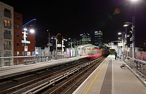
East India DLR station
Docklands Light Railway station
Distance: Approx. 56 meters
Latitude and longitude: 51.5093,-0.0021
East India is a station on Docklands Light Railway (DLR) in Leamouth, east London. It takes its name from the nearby former East India Docks of the Port of London, where ships trading with the Indian subcontinent used to dock. It is on the Beckton and Woolwich Arsenal branches of the DLR, and is in Travelcard Zones 2 and 3.
Telehouse Europe
British telecommunications service provider
Distance: Approx. 213 meters
Latitude and longitude: 51.5116,-0.0013
Telehouse is a major carrier-neutral colocation, information and communications technology services provider based in Docklands, London. Established in 1988, it operates eight facilities in London, Paris and Frankfurt. Part of the global Telehouse network of data centres, the brand has 45 colocation facilities in 26 major cities around the world including Moscow, Istanbul, Johannesburg, Cape Town, Beijing, Shanghai, Hong Kong, Singapore, Vietnam, Seoul, Tokyo, New York and Los Angeles.

East India Docks
Historic docks in Blackwall, London
Distance: Approx. 251 meters
Latitude and longitude: 51.50811111,0.00097222
The East India Docks were a group of docks in Blackwall, east London, north-east of the Isle of Dogs. Today only the entrance basin and listed perimeter wall remain visible.

Blackwall railway station
Former railway station in Tower Hamlets, London
Distance: Approx. 206 meters
Latitude and longitude: 51.50817,0.00007
Blackwall was a railway station in Blackwall, London, that served as the eastern terminus of the Commercial Railway (later the London and Blackwall Railway). It was located on the south side of the East India Docks, near the shore of the River Thames, 3 miles 43 chains (5.7 km) down-line from the western terminus at Fenchurch Street. The station was designed by architect William Tite in an ornate Italianate style.

Blackwall Yard
Former shipyard in Blackwall, London
Distance: Approx. 329 meters
Latitude and longitude: 51.50694444,-0.00333333
Blackwall Yard is a small body of water that used to be a shipyard on the River Thames in Blackwall, engaged in ship building and later ship repairs for over 350 years. The yard closed in 1987.

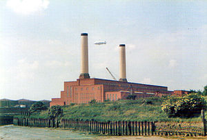
Brunswick Wharf Power Station
Former coal and oil-fired power station
Distance: Approx. 253 meters
Latitude and longitude: 51.5081,0.001
Brunswick Wharf Power Station (also known as Blackwall Power Station) was a coal- and oil-fired power station on the River Thames at Blackwall in London. The station was planned from 1939 by Poplar Borough Council but construction only started in 1947 after the Second World War. It was decommissioned in 1984, and the site was redeveloped.

East India Dock House
Listed building in Tower Hamlets, London
Distance: Approx. 330 meters
Latitude and longitude: 51.5111,-0.0058
East India Dock House is a Grade II* listed building in Poplar and is in the London Borough of Tower Hamlets. It was originally built in 1988 as a printworks for the Financial Times.
Republic (office campus)
Education and Office Campus in London, England
Distance: Approx. 224 meters
Latitude and longitude: 51.509943,-0.004803
Republic is an education and office campus in London, England, situated in the London Borough of Tower Hamlets, near Canary Wharf and Canning Town. It sits on the historic site of the East India Docks and is currently occupied as a multi-use innovation campus with both education and office space.

Blackwall Rock
Reef in the River Thames
Distance: Approx. 369 meters
Latitude and longitude: 51.50638889,-0.00197222
The Blackwall Rock was a reef in the River Thames in East London. The rock provided a useful shelter for moored vessels, but also proved a hazardous obstruction to river navigation. It was removed in the early 19th century following the opening of the adjacent West India Docks.

Mulberry Place
Municipal building in London, England
Distance: Approx. 320 meters
Latitude and longitude: 51.51,-0.0062
Mulberry Place, formerly Tower Hamlets Town Hall, is a building in Nutmeg Lane, Blackwall, London. It was the headquarters of Tower Hamlets London Borough Council from 1992 to 2023, before their relocation to the new Tower Hamlets Town Hall in Whitechapel Road.

Virginia Quay Settlers Monument
Memorial in London
Distance: Approx. 241 meters
Latitude and longitude: 51.50791667,0.00036111
The Virginia Quay Settlers Monument is a public monument in Tower Hamlets, London, to the first settlers of the Colony of Virginia who departed from here in 1606. The monument has its origins in a plaque erected on the Brunswick Dock master's house in 1928. The house was badly damaged by bombing during the Second World War and in 1951 the plaque was incorporated into a monument erected during development of the site into the Brunswick Wharf Power Station.
Weather in this IP's area
overcast clouds
3 Celsius
3 Celsius
3 Celsius
3 Celsius
1020 hPa
71 %
1020 hPa
1016 hPa
10000 meters
0.96 m/s
0.96 m/s
152 degree
96 %