Country:
Region:
City:
Latitude and Longitude:
Time Zone:
Postal Code:
IP information under different IP Channel
ip-api
Country
Region
City
ASN
Time Zone
ISP
Blacklist
Proxy
Latitude
Longitude
Postal
Route
Luminati
Country
ASN
Time Zone
Europe/Lisbon
ISP
Secretaria-Geral Ministerio da Administracao Interna
Latitude
Longitude
Postal
IPinfo
Country
Region
City
ASN
Time Zone
ISP
Blacklist
Proxy
Latitude
Longitude
Postal
Route
db-ip
Country
Region
City
ASN
Time Zone
ISP
Blacklist
Proxy
Latitude
Longitude
Postal
Route
ipdata
Country
Region
City
ASN
Time Zone
ISP
Blacklist
Proxy
Latitude
Longitude
Postal
Route
Popular places and events near this IP address

Lisbon Cathedral
Roman Catholic Cathedral located in Lisbon, Portugal
Distance: Approx. 262 meters
Latitude and longitude: 38.70972222,-9.13305556
The Cathedral of Saint Mary Major (Portuguese: Santa Maria Maior de Lisboa or Sé-Catedral Metropolitana Patriarcal de Santa Maria Maior de Lisboa), often called Lisbon Cathedral or simply the Sé (Sé de Lisboa), is a Roman Catholic cathedral located in Lisbon, Portugal. It is the oldest church in the city, built in 1147 upon the ruins of a mosque. The cathedral has survived many earthquakes and has been modified, renovated and restored several times, resulting in a mix of different architectural styles.

Lisbon Baixa
Neighborhood in Santa Maria Maior, Lisbon
Distance: Approx. 178 meters
Latitude and longitude: 38.71138889,-9.13722222
The Baixa ("Downtown"), also known as the Baixa Pombalina (IPA: [ˈbajʃɐ põbɐˈlinɐ]; "Pombaline Downtown"), is a neighborhood in the historic center of Lisbon, Portugal. It consists of the grid of streets north of the Praça do Comércio, roughly between the Cais do Sodré and the Alfama district beneath the Lisbon Castle, and extends northwards towards the Rossio and Figueira squares and the Avenida da Liberdade, a tree-lined boulevard noted for its tailoring shops and cafes.

São Jorge Castle
Historic castle in Lisbon, Portugal
Distance: Approx. 308 meters
Latitude and longitude: 38.71388889,-9.13361111
São Jorge Castle (Portuguese: Castelo de São Jorge; Portuguese pronunciation: [kɐʃˈtɛlu dɨ sɐ̃w̃ ˈʒɔɾʒɨ]), sometimes known in English as Saint George's Castle, is a historic castle in the Portuguese capital of Lisbon, located in the freguesia of Santa Maria Maior. Human occupation of the castle hill dates to at least the 8th century BC while the oldest fortifications on the site date from the 2nd century BC. The hill on which Saint George's Castle stands has played an important part in the history of Lisbon, having served as the location of fortifications occupied successively by Phoenicians, Carthaginians, Romans, and Moors, before its conquest by the Portuguese in the 1147 Siege of Lisbon. Since the 12th century, the castle has variously served as a royal palace, a military barracks, home of the Torre do Tombo National Archive, and now as a national monument and museum.
Olisipo
Lisbon, Portugal in Roman times
Distance: Approx. 138 meters
Latitude and longitude: 38.7122204,-9.1339731
Municipium Cives Romanorum Felicitas Julia Olisipo (in Latin: Olisippo or Ulyssippo ; in Greek: Ὀλισσιπών, Olissipṓn, or Ὀλισσιπόνα, Olissipóna) was the ancient name of modern-day Lisbon while it was part of the Roman Empire.

Church of Nossa Senhora da Conceição Velha
Church in Lisbon, Portugal
Distance: Approx. 293 meters
Latitude and longitude: 38.70888889,-9.13416667
The Church of Nossa Senhora da Conceição (Portuguese: Igreja de Nossa Senhora da Conceição Velha) is a church in the civil parish of Madalena, in the municipality of Lisbon. The Church of Conceição dos Freires, or Conceição Velha, (known as the Church of the Misericórdia) was not included in the original plans to reconstruct the Lisbon riverfront, even though it was partially ruined. Instead, King Joseph gave the monks from the Church of Nossa Senhora da Conceição (which was destroyed) the location of the Misericórdia church, and ordered Pombaline architect Francisco António Ferreira (with the collaboration of Honorato José Correia) in 1770, to rebuild the structure.

Church of Saint Anthony of Lisbon
Roman Catholic church in Lisbon, Portugal
Distance: Approx. 206 meters
Latitude and longitude: 38.71,-9.13361111
The Church of Saint Anthony of Lisbon (Portuguese: Igreja de Santo António de Lisboa) is a Roman Catholic church located in Lisbon, Portugal. It is dedicated to Saint Anthony of Lisbon (also known in the Christian world as Saint Anthony of Padua). According to tradition, the church was built on the site where the saint was born, in 1195.

Casa dos Bicos
Building in Lisbon
Distance: Approx. 333 meters
Latitude and longitude: 38.70911111,-9.13269444
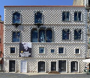
The Casa dos Bicos (Portuguese pronunciation: [ˈkazɐ ðuʒ ˈβikuʃ]; "House of the Beaks/Spikes") is a historical house in the civil parish of Santa Maria Maior, in the Portuguese municipality of Lisbon. The house, built in the early 16th century in the Alfama neighbourhood, has a curious façade of spikes, influenced by Italian Renaissance palaces and Portuguese Manueline styles. It survived the disastrous 1755 Lisbon earthquake that destroyed much of the city, but over time was abandoned as a residence and used as a warehouse.

Madalena, Lisbon
Civil parish in Lisbon, Portugal
Distance: Approx. 161 meters
Latitude and longitude: 38.71,-9.13472
Madalena (English: Magdalene) is a former civil parish (freguesia) in the city and municipality of Lisbon, Portugal. It has a total area of 0.11 km2 and total population of 380 inhabitants (2001); density: 3,423 inhabitants/km2. At the administrative reorganization of Lisbon on 8 December 2012 it became part of the parish Santa Maria Maior.
Igreja da Madalena
Distance: Approx. 126 meters
Latitude and longitude: 38.71027778,-9.135
Church of the Magdalene (Portuguese: Igreja da Madalena) is a church in Lisbon, Portugal. Its portal is classified as a National Monument.

Penafiel Palace
Palace in Santa Maria Maior, Portugal
Distance: Approx. 91 meters
Latitude and longitude: 38.71086111,-9.13438889
The Palace of the Counts of Penafiel (Portuguese: Palácio dos Condes de Penafiel), commonly known as Penafiel Palace (Palácio Penafiel) and also referred as Palace of the Postmaster-General (Palácio do Correio-Mor), is a palace in Portugal, located in the Santa Maria Maior parish, Lisbon. It presently serves as the global headquarters of the Community of Portuguese Language Countries, also known as the Lusophone Community.

Santa Maria Maior, Lisbon
Civil parish in Lisbon, Portugal
Distance: Approx. 192 meters
Latitude and longitude: 38.713,-9.136
Santa Maria Maior (Portuguese pronunciation: [ˈsɐ̃tɐ mɐˈɾi.ɐ mɐˈjɔɾ]) is a freguesia (civil parish) and district of Lisbon, the capital of Portugal. Located in the historic center of Lisbon, Santa Maria Maior is to the west of São Vicente, east of Misericórdia, and south of Arroios and Santo António. It is home to numerous historic monuments, including Lisbon Cathedral, the Rossio, and the Praça do Comércio, as well as famous neighborhoods, such as the Lisbon Baixa, as well as parts of Bairro Alto and Alfama.

José Saramago Foundation
Distance: Approx. 334 meters
Latitude and longitude: 38.7091,-9.1327
The José Saramago Foundation is a cultural private institution located in the Casa dos Bicos, in Lisbon (Portugal). A smaller branch has been opened in Azinhaga do Ribatejo, home village of José Saramago, the Portuguese Nobel Prize in Literature 1998. Founded by the writer in June 2007, its main institutional principles are to defend and spread the Universal Declaration of Human Rights, the promotion of culture in Portugal as well as in all the countries, and particular concerns about environmentalism.
Weather in this IP's area
few clouds
18 Celsius
18 Celsius
17 Celsius
19 Celsius
1018 hPa
78 %
1018 hPa
1010 hPa
10000 meters
1.54 m/s
340 degree
20 %
07:22:34
17:21:18
