91.226.79.165 - IP Lookup: Free IP Address Lookup, Postal Code Lookup, IP Location Lookup, IP ASN, Public IP
Country:
Region:
City:
Location:
Time Zone:
Postal Code:
IP information under different IP Channel
ip-api
Country
Region
City
ASN
Time Zone
ISP
Blacklist
Proxy
Latitude
Longitude
Postal
Route
Luminati
Country
Region
ve
City
pecsely
ASN
Time Zone
Europe/Budapest
ISP
MVM NET Zrt.
Latitude
Longitude
Postal
IPinfo
Country
Region
City
ASN
Time Zone
ISP
Blacklist
Proxy
Latitude
Longitude
Postal
Route
IP2Location
91.226.79.165Country
Region
veszprem
City
tihany
Time Zone
Europe/Budapest
ISP
Language
User-Agent
Latitude
Longitude
Postal
db-ip
Country
Region
City
ASN
Time Zone
ISP
Blacklist
Proxy
Latitude
Longitude
Postal
Route
ipdata
Country
Region
City
ASN
Time Zone
ISP
Blacklist
Proxy
Latitude
Longitude
Postal
Route
Popular places and events near this IP address

Balatonfüred
Town in Veszprém, Hungary
Distance: Approx. 4065 meters
Latitude and longitude: 46.95,17.88333333
Balatonfüred (German: Bad Plattensee, Slovak: Blatenské Teplice) is a resort town in Veszprém county, in Hungary. The town with a population of 13,000 is situated on the northern shore of Lake Balaton. It is considered to be the capital of the Northern lake shore and is a yachting destination.

Tihany
Place in Veszprém, Hungary
Distance: Approx. 927 meters
Latitude and longitude: 46.90891,17.87923
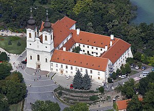
Tihany (Hungarian: [ˈtihɒɲ]) is a village on the northern shore of Lake Balaton on the Tihany Peninsula (Hungary, Veszprém County). The whole peninsula is a historical district. The center of the district is the Benedictine Tihany Abbey, which was founded in 1055 AD by András (Andrew) I, who is buried in the crypt.

Csopak
Place in Veszprém, Hungary
Distance: Approx. 7533 meters
Latitude and longitude: 46.97829,17.91877
Csopak is a village in Veszprém county, Hungary at Lake Balaton. There is a beach in the village.

Aszófő
Place in Veszprém, Hungary
Distance: Approx. 4746 meters
Latitude and longitude: 46.93026,17.83168
Aszófő is a village in Veszprém county, Hungary.

Balatonudvari
Place in Veszprém, Hungary
Distance: Approx. 7006 meters
Latitude and longitude: 46.90079,17.79904
Balatonudvari is a village in Veszprém county.

Örvényes
Place in Veszprém, Hungary
Distance: Approx. 5265 meters
Latitude and longitude: 46.91455,17.81997
Örvényes is a village at lake Balaton, in Veszprém county, Hungary.

Balatonföldvár
Town in Southern Transdanubia, Hungary
Distance: Approx. 6570 meters
Latitude and longitude: 46.85469,17.88797
Balatonföldvár (Hungarian pronunciation: [ˈbɒlɒtoɱføldvaːr], German: Földwahr) is a popular resort town in Somogy County, Hungary, on the southern side of Lake Balaton, approximately 120 km southwest from Budapest and about 23 km southwest from Siófok, the "capital of Balaton". Balatonföldvár is a frequently visited tourist destination among Hungarians and foreign guests (especially Germans and Austrians) because of its natural beauties (like the loess hill and the big flowery parks), historical heritages (such as the Celtic path, the old mansions and villas) or its countless leisure opportunities. The town offer several water sport (sailing, windsurfing, fishing, rowing etc.) and mainland sport (beach volleyball, bicycle pathes, football etc.) activities.
Zamárdi
Town in Somogy, Hungary
Distance: Approx. 5695 meters
Latitude and longitude: 46.88434,17.95051
Zamárdi is a town in Somogy County, Hungary. It is known for its beaches at Lake Balaton and for its music festivals during the summer (e.g. Strand Festival, Balaton Sound etc.).

Szántód
Village in Southern Transdanubia, Hungary
Distance: Approx. 5619 meters
Latitude and longitude: 46.880508,17.944858
Szántód is a village in Somogy county, Hungary situated between Balatonföldvár and Zamárdi on the shore of the Lake Balaton. The village is known for its ferry, ferryboats, views of Tihany from Szántód and the Szántódpuszta Tourist and Cultural Center which is a village museum ("skanzen"). It's apprpximately 13.4 km from Siófok, the major town of the area, 65.8 km from Kaposvár, the capital of Somogy County and 117 km from Budapest, the capital of Hungary.

Balaton Sound
Hungarian electronic music festival
Distance: Approx. 4299 meters
Latitude and longitude: 46.88404167,17.92539722
Balaton Sound (also known as Heineken Balaton Sound between 2007 and 2012 and as MasterCard Balaton Sound since 2013 for sponsorship reasons) is one of Europe's largest open air electronic music festivals. Held annually since 2007 on the southern bank of Lake Balaton, Hungary, it features live acts and DJs from all around the world, from established artists to new names. The event was co-created by the organizers of Sziget Festival.

Tihany Abbey
Benedictine monastery in Hungary
Distance: Approx. 28 meters
Latitude and longitude: 46.91388889,17.88944444
The Tihany Abbey is a Benedictine monastery established in Tihany in the Kingdom of Hungary in 1055. Its patrons are the Virgin Mary and Saint Aignan of Orleans.

Balatonfüred District
Districts of Hungary in Veszprém
Distance: Approx. 5412 meters
Latitude and longitude: 46.96123629,17.87424589
Balatonfüred (Hungarian: Balatonfüredi járás) is a district in southern part of Veszprém County. Balatonfüred is also the name of the town where the district seat is found. The district is located in the Central Transdanubia Statistical Region.
Weather in this IP's area
few clouds
-1 Celsius
-4 Celsius
-1 Celsius
1 Celsius
1022 hPa
95 %
1022 hPa
1003 hPa
10000 meters
2.24 m/s
2.68 m/s
225 degree
14 %
