Country:
 Poland
Region:
City:
Latitude and Longitude:
Time Zone:
Postal Code:
IP information under different IP Channel
ip-api
Country
Region
City
ASN
Time Zone
ISP
Blacklist
Proxy
Latitude
Longitude
Postal
Route
IPinfo
Country
Region
City
ASN
Time Zone
ISP
Blacklist
Proxy
Latitude
Longitude
Postal
Route
MaxMind
Country
Region
City
ASN
Time Zone
ISP
Blacklist
Proxy
Latitude
Longitude
Postal
Route
Luminati
Country
PLRegion
10
City
zdunskawola
ASN
Time Zone
Europe/Warsaw
ISP
IWACOM Sp. z o.o.
Latitude
Longitude
Postal
db-ip
Country
Region
City
ASN
Time Zone
ISP
Blacklist
Proxy
Latitude
Longitude
Postal
Route
ipdata
Country
Region
City
ASN
Time Zone
ISP
Blacklist
Proxy
Latitude
Longitude
Postal
Route
Popular places and events near this IP address

Zduńska Wola
Place in Łódź Voivodeship, Poland
Distance: Approx. 1292 meters
Latitude and longitude: 51.6,18.96666667
Zduńska Wola [ˈzduɲska ˈvɔla] is a city in central Poland with 40,730 inhabitants (2021). It is the seat of Zduńska Wola County in the Łódź Voivodeship. The city was once one of the largest cloth, linen and cotton weaving centres in Poland and is the birthplace of Saint Maximilian Kolbe as well as Maksymilian Faktorowicz, the founder of Max Factor cosmetics company.

Zduńska Wola County
County in Łódź Voivodeship, Poland
Distance: Approx. 1292 meters
Latitude and longitude: 51.6,18.96666667
Zduńska Wola County (Polish: powiat zduńskowolski) is a unit of territorial administration and local government (powiat) in Łódź Voivodeship, central Poland. It came into being on January 1, 1999, as a result of the Polish local government reforms passed in 1998. Its administrative seat and largest town is Zduńska Wola, which lies 41 kilometres (25 mi) south-west of the regional capital Łódź.

Zduńska Wola Karsznice
Distance: Approx. 2697 meters
Latitude and longitude: 51.58944444,18.99444444
Zduńska Wola Karsznice is one of the biggest rail junctions in Poland, located in central part of the country, within the borders of the town of Zduńska Wola (Łódź Voivodeship). It is a station along the Polish Coal Trunk-Line; before 1930 it had been a separate village, but construction of the Trunk-Line resulted in creation of a separate district for rail workers, with numerous condominiums. A few kilometers north of Karsznice, the Trunk-Line crosses the Łódź–Tuplice rail line linking Warsaw through Łódź and Ostrów Wielkopolski to Poznań and Wrocław.
Gmina Zduńska Wola
Gmina in Łódź Voivodeship, Poland
Distance: Approx. 1292 meters
Latitude and longitude: 51.6,18.96666667
Gmina Zduńska Wola is a rural gmina (administrative district) in Zduńska Wola County, Łódź Voivodeship, in central Poland. Its seat is the town of Zduńska Wola, although the town is not part of the territory of the gmina. The gmina covers an area of 111.54 square kilometres (43.1 sq mi), and as of 2006 its total population is 11,256.
Młodawin Dolny
Village in Łódź Voivodeship, Poland
Distance: Approx. 2750 meters
Latitude and longitude: 51.56805556,18.97138889
Młodawin Dolny [mwɔˈdavin ˈdɔlnɨ] is a village in the administrative district of Gmina Zapolice, within Zduńska Wola County, Łódź Voivodeship, in central Poland. It lies approximately 7 kilometres (4 mi) north-east of Zapolice, 4 km (2 mi) south of Zduńska Wola, and 42 km (26 mi) south-west of the regional capital Łódź.

Paprotnia, Zduńska Wola County
Village in Łódź Voivodeship, Poland
Distance: Approx. 2706 meters
Latitude and longitude: 51.57055556,18.93361111
Paprotnia [paˈprɔtɲa] is a village in the administrative district of Gmina Zapolice, within Zduńska Wola County, Łódź Voivodeship, in central Poland. It lies approximately 5 kilometres (3 mi) north-east of Zapolice, 4 km (2 mi) south-west of Zduńska Wola, and 44 km (27 mi) south-west of the regional capital Łódź.
Biały Ług, Łódź Voivodeship
Village in Łódź Voivodeship, Poland
Distance: Approx. 2715 meters
Latitude and longitude: 51.60638889,18.98555556
Biały Ług [ˈbjawɨ ˈwuk] is a village in the administrative district of Gmina Zduńska Wola, within Zduńska Wola County, Łódź Voivodeship, in central Poland. It lies approximately 2 kilometres (1 mi) north-east of Zduńska Wola and 39 km (24 mi) south-west of the regional capital Łódź.
Henryków, Zduńska Wola County
Village in Łódź Voivodeship, Poland
Distance: Approx. 2147 meters
Latitude and longitude: 51.60527778,18.97583333
Henryków [xɛnˈrɨkuf] is a village in the administrative district of Gmina Zduńska Wola, within Zduńska Wola County, Łódź Voivodeship, in central Poland. It lies approximately 40 kilometres (25 mi) south-west of the regional capital Łódź.
Janiszewice
Village in Łódź Voivodeship, Poland
Distance: Approx. 2916 meters
Latitude and longitude: 51.61666667,18.95
Janiszewice [janiʂɛˈvit͡sɛ] is a village in the administrative district of Gmina Zduńska Wola, within Zduńska Wola County, Łódź Voivodeship, in central Poland. It lies approximately 3 kilometres (2 mi) north-west of Zduńska Wola and 41 km (25 mi) south-west of the regional capital Łódź. During the German occupation of Poland (World War II), the Germans operated a Nazi prison in Janiszewice that was subordinate to the prison in Sieradz.
Maciejów, Zduńska Wola County
Village in Łódź Voivodeship, Poland
Distance: Approx. 2953 meters
Latitude and longitude: 51.61722222,18.95638889
Maciejów [maˈt͡ɕɛjuf] is a village in the administrative district of Gmina Zduńska Wola, within Zduńska Wola County, Łódź Voivodeship, in central Poland.

Casimir the Great High School in Zduńska Wola
High school in Zduńska Wola, Łódź Voivodeship, Poland
Distance: Approx. 1746 meters
Latitude and longitude: 51.602192,18.938319
Casimir the Great High School in Zduńska Wola is a public secondary school founded in 1905, and located at 6 Dąbrowskiego Street in Zduńska Wola, Poland.
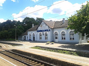
Zduńska Wola railway station
Railway station in Poland
Distance: Approx. 2383 meters
Latitude and longitude: 51.61138889,18.94666667
Zduńska Wola is the main railway station for the town of Zduńska Wola, Łódź Voivodeship. Initially built in early 1900s to serve Warsaw-Kalisz Railway, it is currently an important interchange, serving trains running on Coal Trunk Railway from Karsznice station toward Sieradz and Kalisz. For passenger service, it serves as stopping point for PKP Intercity trains running between Wrocław and Warsaw, PolRegio routes from Łódź to Poznań and Wrocław, and ŁKA services to Sieradz.
Weather in this IP's area
clear sky
4 Celsius
1 Celsius
4 Celsius
6 Celsius
1027 hPa
88 %
1027 hPa
1004 hPa
10000 meters
3.55 m/s
7.63 m/s
141 degree
1 %
07:17:07
17:40:24