91.223.40.40 - IP Lookup: Free IP Address Lookup, Postal Code Lookup, IP Location Lookup, IP ASN, Public IP
Country:
Region:
City:
Location:
Time Zone:
Postal Code:
ISP:
ASN:
language:
User-Agent:
Proxy IP:
Blacklist:
IP information under different IP Channel
ip-api
Country
Region
City
ASN
Time Zone
ISP
Blacklist
Proxy
Latitude
Longitude
Postal
Route
db-ip
Country
Region
City
ASN
Time Zone
ISP
Blacklist
Proxy
Latitude
Longitude
Postal
Route
IPinfo
Country
Region
City
ASN
Time Zone
ISP
Blacklist
Proxy
Latitude
Longitude
Postal
Route
IP2Location
91.223.40.40Country
Region
grand-est
City
mommenheim
Time Zone
Europe/Paris
ISP
Language
User-Agent
Latitude
Longitude
Postal
ipdata
Country
Region
City
ASN
Time Zone
ISP
Blacklist
Proxy
Latitude
Longitude
Postal
Route
Popular places and events near this IP address
Bernolsheim
Commune in Grand Est, France
Distance: Approx. 3502 meters
Latitude and longitude: 48.7567,7.6906
Bernolsheim is a commune in the Bas-Rhin department in Grand Est in northeastern France.

Donnenheim
Commune in Grand Est, France
Distance: Approx. 4398 meters
Latitude and longitude: 48.7186,7.6525
Donnenheim (French pronunciation: [dɔnənaim] ) is a commune in the Bas-Rhin department in Grand Est in north-eastern France. As with other parts of Alsace and Bas-Rhin, Donnenheim has had periods under German rule, and its name is Germanic. Donnenheim has been part of France since 1790, with an interlude of German rule 1871-1919.
Hochstett
Commune in Grand Est, France
Distance: Approx. 3458 meters
Latitude and longitude: 48.7789,7.6772
Hochstett is a commune in the Bas-Rhin department in Grand Est in north-eastern France.

Minversheim
Commune in Grand Est, France
Distance: Approx. 3459 meters
Latitude and longitude: 48.7858,7.6231
Minversheim is a commune in the Bas-Rhin department and Grand Est region of north-eastern France.

Mutzenhouse
Commune in Grand Est, France
Distance: Approx. 4307 meters
Latitude and longitude: 48.7417,7.5894
Mutzenhouse (German: Mutzenhausen) is a commune in the Bas-Rhin department in Grand Est in north-eastern France.
Schwindratzheim
Commune in Grand Est, France
Distance: Approx. 2965 meters
Latitude and longitude: 48.7575,7.6025
Schwindratzheim (French pronunciation: [ʃvindratsaim]; Alsatian: Schwìngelse) is a commune in the Bas-Rhin department in Grand Est in north-eastern France.
Wahlenheim
Commune in Grand Est, France
Distance: Approx. 3246 meters
Latitude and longitude: 48.7647,7.6858
Wahlenheim (French pronunciation: [valənaim]; Alsatian: Wàhle) is a commune in the Bas-Rhin department in Grand Est in north-eastern France.

Waltenheim-sur-Zorn
Commune in Grand Est, France
Distance: Approx. 1496 meters
Latitude and longitude: 48.7472,7.63
Waltenheim-sur-Zorn (German: Waltenheim an der Zorn) is a commune in the Bas-Rhin department in Grand Est in north-eastern France. It lies on the road D332 next to the Marne-Rhine Canal.
Wingersheim
Part of Wingersheim-les-Quatre-Bans in Grand Est, France
Distance: Approx. 3867 meters
Latitude and longitude: 48.7231,7.6367
Wingersheim (French pronunciation: [viŋ(ɡ)ərsaim]; Alsatian: Wìngersche) is a former commune in the Bas-Rhin department in north-eastern France. On 1 January 2016, it was merged into the new commune Wingersheim-les-Quatre-Bans.
Wittersheim
Commune in Grand Est, France
Distance: Approx. 2937 meters
Latitude and longitude: 48.7817,7.6592
Wittersheim is a commune in the Bas-Rhin department in Grand Est in north-eastern France. It has a population of 671 (2019) and an area of 7.05 km2.
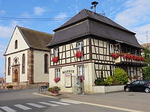
Mommenheim, Bas-Rhin
Commune in Grand Est, France
Distance: Approx. 173 meters
Latitude and longitude: 48.7583,7.645
Mommenheim (French pronunciation: [mɔmənaim]; Alsatian: Mummle) is a commune in the Bas-Rhin department. The department is in the historic Alsace region of France, and is itself within the Grand Est administrative region of north-eastern France.
Wingersheim-les-Quatre-Bans
Commune in Grand Est, France
Distance: Approx. 3995 meters
Latitude and longitude: 48.722,7.636
Wingersheim-les-Quatre-Bans is a commune in the Bas-Rhin department of northeastern France. The municipality was established on 1 January 2016 and consists of the former communes of Gingsheim, Hohatzenheim, Mittelhausen and Wingersheim.
Weather in this IP's area
overcast clouds
-0 Celsius
-3 Celsius
-1 Celsius
-0 Celsius
1023 hPa
84 %
1023 hPa
999 hPa
10000 meters
2.15 m/s
3.48 m/s
56 degree
100 %


