91.223.136.181 - IP Lookup: Free IP Address Lookup, Postal Code Lookup, IP Location Lookup, IP ASN, Public IP
Country:
Region:
City:
Location:
Time Zone:
Postal Code:
IP information under different IP Channel
ip-api
Country
Region
City
ASN
Time Zone
ISP
Blacklist
Proxy
Latitude
Longitude
Postal
Route
Luminati
Country
IPinfo
Country
Region
City
ASN
Time Zone
ISP
Blacklist
Proxy
Latitude
Longitude
Postal
Route
IP2Location
91.223.136.181Country
Region
donetska oblast
City
kostiantynivka
Time Zone
Europe/Kiev
ISP
Language
User-Agent
Latitude
Longitude
Postal
db-ip
Country
Region
City
ASN
Time Zone
ISP
Blacklist
Proxy
Latitude
Longitude
Postal
Route
ipdata
Country
Region
City
ASN
Time Zone
ISP
Blacklist
Proxy
Latitude
Longitude
Postal
Route
Popular places and events near this IP address

Kostiantynivka
City in Donetsk Oblast, Ukraine
Distance: Approx. 955 meters
Latitude and longitude: 48.53333333,37.71666667
Kostiantynivka (Ukrainian: Костянтинівка, IPA: [kosʲtʲɐnˈtɪn⁽ʲ⁾iu̯kɐ] ; Russian: Константиновка, romanized: Konstantinovka) is an industrial city in Donetsk Oblast, eastern Ukraine. It is situated on the Kryvyi Torets river. During the Soviet era, the city developed into a major centre for the production of iron, zinc, steel, and glass.

Kostiantynivka Raion
Former subdivision of Donetsk Oblast, Ukraine
Distance: Approx. 232 meters
Latitude and longitude: 48.52666667,37.70416667
Kostiantynivka Raion (Ukrainian: Костянтинівський район; Russian: Константиновский район) was one of the administrative raions (a district) of Donetsk Oblast in eastern Ukraine. It covered approximately 4.4 percent of the oblast's total area. The raion was created on 7 March 1923 as part of the Ukrainian Soviet Socialist Republic.
Oleksiievo-Druzhkivka
Urban locality in Donetsk Oblast, Ukraine
Distance: Approx. 8986 meters
Latitude and longitude: 48.58055556,37.61472222
Oleksiievo-Druzhkivka (Ukrainian: Олексієво-Дружківка) is an rural settlement in Kramatorsk Raion, Donetsk Oblast, eastern Ukraine. Population: 6,924 (2022 estimate). Until 18 July 2020, Oleksiievo-Druzhkivka was located in Druzhkivka Municipality.

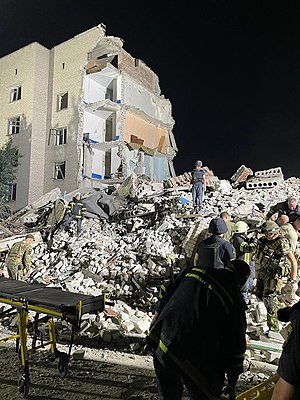
July 2022 Chasiv Yar missile strike
July 2022 Russian missile attack in Ukraine
Distance: Approx. 9159 meters
Latitude and longitude: 48.55665,37.82323
A missile strike on two residential buildings in Chasiv Yar was carried out by the Russian army at 21:17 local time on 9 July 2022, during the ongoing Russian invasion of Ukraine. At least 48 people were killed. Due to the impact, a five-story residential building partially collapsed.
Stinky, Donetsk Oblast
Place in Donetsk Oblast, Ukraine
Distance: Approx. 5941 meters
Latitude and longitude: 48.57722222,37.73694444
Stinky (Ukrainian: Сті́нки) is a rural settlement in eastern Ukraine, located in Kramatorsk Raion, Donetsk Oblast. It had a population of 265 people, as of 2001.
Viroliubivka
Village in Donetsk Oblast, Ukraine
Distance: Approx. 9313 meters
Latitude and longitude: 48.61111111,37.71666667
Viroliubivka (Ukrainian: Віролюбівка; Russian: Веролюбовка) is a village in Kostiantynivka urban hromada, Kramatorsk Raion, Donetsk Oblast, eastern Ukraine. It is located 66.33 kilometres (41.22 mi) north by west (NbW) from the centre of Donetsk city.
Weather in this IP's area
broken clouds
-1 Celsius
-5 Celsius
-1 Celsius
-1 Celsius
1027 hPa
92 %
1027 hPa
1008 hPa
10000 meters
2.65 m/s
5.88 m/s
22 degree
56 %
