Country:
Region:
City:
Latitude and Longitude:
Time Zone:
Postal Code:
IP information under different IP Channel
ip-api
Country
Region
City
ASN
Time Zone
ISP
Blacklist
Proxy
Latitude
Longitude
Postal
Route
Luminati
Country
ASN
Time Zone
Europe/Bratislava
ISP
Kia Slovakia s. r. o.
Latitude
Longitude
Postal
IPinfo
Country
Region
City
ASN
Time Zone
ISP
Blacklist
Proxy
Latitude
Longitude
Postal
Route
db-ip
Country
Region
City
ASN
Time Zone
ISP
Blacklist
Proxy
Latitude
Longitude
Postal
Route
ipdata
Country
Region
City
ASN
Time Zone
ISP
Blacklist
Proxy
Latitude
Longitude
Postal
Route
Popular places and events near this IP address

Strečno
Village in Slovakia
Distance: Approx. 3323 meters
Latitude and longitude: 49.18805556,18.86722222
Strečno (Hungarian: Sztrecsény) is a village and municipality in the Žilina District in the Žilina Region in North Slovakia. It is located by the Váh River in the Malá Fatra Mts. Situated 7 km east from Žilina, Strečno is most famous for its gothic castle ruins.

Belá, Žilina District
Village and municipality in Slovakia
Distance: Approx. 4811 meters
Latitude and longitude: 49.23527778,18.94555556
Belá (Hungarian: Bella) is a village and municipality in Žilina District in the Žilina Region of northern Slovakia.

Lysica
Village and municipality in Slovakia
Distance: Approx. 4456 meters
Latitude and longitude: 49.25,18.91666667
Lysica (Hungarian: Trencsénladány) is a village and municipality in Žilina District in the Žilina Region of northern Slovakia.

Nededza
Village and municipality in Slovakia
Distance: Approx. 3922 meters
Latitude and longitude: 49.21666667,18.83333333
Nededza (Hungarian: Vágnedec) is a village and municipality in Žilina District in the Žilina Region of northern Slovakia.

Nezbudská Lúčka
Village and municipality in Slovakia
Distance: Approx. 3818 meters
Latitude and longitude: 49.18333333,18.86666667
Nezbudská Lúčka (Hungarian: Óváralja) is a village and municipality in Žilina District in the Žilina Region of northern Slovakia.

Krasňany
Village and municipality in Slovakia
Distance: Approx. 951 meters
Latitude and longitude: 49.21666667,18.9
Krasňany (Hungarian: Karasznyán) is a village and municipality in Žilina District in the Žilina Region of northern Slovakia.

Dolná Tižina
Village and municipality in Slovakia
Distance: Approx. 2152 meters
Latitude and longitude: 49.21666667,18.91666667
Dolná Tižina (Hungarian: Alsótizsény) is a village and municipality in Žilina District in the Žilina Region of northern Slovakia.

Mojš
Village and municipality in Slovakia
Distance: Approx. 5391 meters
Latitude and longitude: 49.2,18.81666667
Mojš (Hungarian: Majosfalva) is a village and municipality in Žilina District in the Žilina Region of northern Slovakia.

Gbeľany
Distance: Approx. 2842 meters
Latitude and longitude: 49.21222222,18.84833333
Gbeľany (Hungarian: Egbelény) is a village and municipality in Žilina District in the Žilina Region of northern Slovakia.

Stráža
Village and municipality in Slovakia
Distance: Approx. 1904 meters
Latitude and longitude: 49.225,18.90833333
Stráža (Hungarian: Nemesőr) is a village and municipality in Žilina District in the Žilina Region of northern Slovakia.

Varín
Village in Slovakia
Distance: Approx. 1682 meters
Latitude and longitude: 49.2,18.88333333
Varín (Hungarian: Várna) is a village and municipality in Žilina District in the Žilina Region of northern Slovakia. It is located at the Malá Fatra National Park and also serves as a tourist resort.

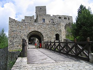
Strečno Castle
Distance: Approx. 4584 meters
Latitude and longitude: 49.17694444,18.86277778
The Strečno Castle (Slovak: Strečniansky hrad)(also called Strechun, Strechyn, Streczen, Streczan alebo Strežín) is a reconstructed ruin of a medieval castle of an irregular plan located in northern Slovakia, 12 km east of Žilina. The castle stands on a 103-metre-high (338 ft) calcite cliff above the international road E50 and village Strečno. Along with the Old castle (Slovak: Starhrad) constitutes a significant landscape landmark of the Upper Váh region.
Weather in this IP's area
fog
2 Celsius
2 Celsius
1 Celsius
2 Celsius
1027 hPa
97 %
1027 hPa
979 hPa
300 meters
1.03 m/s
100 %
06:56:42
16:02:06