91.219.55.38 - IP Lookup: Free IP Address Lookup, Postal Code Lookup, IP Location Lookup, IP ASN, Public IP
Country:
Region:
City:
Location:
Time Zone:
Postal Code:
IP information under different IP Channel
ip-api
Country
Region
City
ASN
Time Zone
ISP
Blacklist
Proxy
Latitude
Longitude
Postal
Route
Luminati
Country
Region
23
City
zaporizhzhya
ASN
Time Zone
Europe/Kyiv
ISP
Kozobrod Andriy Anatoliyovich
Latitude
Longitude
Postal
IPinfo
Country
Region
City
ASN
Time Zone
ISP
Blacklist
Proxy
Latitude
Longitude
Postal
Route
IP2Location
91.219.55.38Country
Region
zaporizka oblast
City
rostushche
Time Zone
Europe/Zaporozhye
ISP
Language
User-Agent
Latitude
Longitude
Postal
db-ip
Country
Region
City
ASN
Time Zone
ISP
Blacklist
Proxy
Latitude
Longitude
Postal
Route
ipdata
Country
Region
City
ASN
Time Zone
ISP
Blacklist
Proxy
Latitude
Longitude
Postal
Route
Popular places and events near this IP address

Zaporizhzhia International Airport
Airport in Zaporizhzhia Oblast, Ukraine
Distance: Approx. 7031 meters
Latitude and longitude: 47.86694444,35.31583333
Zaporizhzhia International Airport (IATA: OZH, ICAO: UKDE) (Ukrainian: Міжнародний аеропорт «Запоріжжя») is the international airport that serves Zaporizhzhia, Ukraine, one of three airfields around the city. The aircraft engine factory Motor Sich has its base here. In May 2020, the airport was extended with a new terminal with a capacity of 400 passengers.

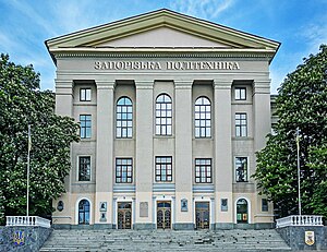
Zaporizhzhia Polytechnic National University
Public university in Zaporizhzhia, Ukraine
Distance: Approx. 7626 meters
Latitude and longitude: 47.8175,35.18444444
Zaporizhzhia Polytechnic National University is a Ukrainian university in Zaporizhzhia in Ukraine.

Classic Private University
Private university in Ukraine
Distance: Approx. 8317 meters
Latitude and longitude: 47.82416667,35.17694444
The Classic Private University is a university in Ukraine. It was founded as Zaporizhzhia Institute of State and Municipal Administration (ZIDMU) in 1992. In November 2007, it changed its name from the "Humanitarian University "ZIDMU" to the "Classical Private University".

Zaporizhzhia National University
Public university in Zaporizhzhia, Ukraine
Distance: Approx. 7875 meters
Latitude and longitude: 47.82,35.1817
Zaporizhzhia National University (ZNU) is a State-sponsored university in Zaporizhzhia, Ukraine. Its full name is "Zaporizhzhia National University of the Ministry of Education, Youth and Sports of Ukraine." On August 11, 1930, Sovnarkom Ukraine approved the list of 27 institutes and departments, including the Zaporizhzhia Institute of Education. In 1931, the Institute of Education was renamed the Pedagogical Institute of Vocational Education.
Zaporizhzhia Governorate
Distance: Approx. 7412 meters
Latitude and longitude: 47.84,35.199
Zaporizhzhia Governorate (Ukrainian: Запорізька губернія, romanized: Zaporizka huberniia) was a territorial division or gubernia of the Ukrainian SSR (Ukraine) that was created in April 1920. The new governorate was temporarily established in place of the Tavria Okruha. Soon after the Ukrainian SSR joined the Soviet Union, the governorate was merged into the Yekaterinoslav Governorate.
Ivano-Hannivka
Rural settlement in Zaporizhzhia Oblast, Ukraine
Distance: Approx. 8361 meters
Latitude and longitude: 47.85027778,35.37694444
Ivano-Hannivka (Ukrainian: Івано-Ганнівка) is a rural settlement in the Zaporizhzhia Raion (district) of Zaporizhzhia Oblast in southern Ukraine. Its population was 96 in the 2001 Ukrainian Census. Administratively, it belongs to the Natalivka Rural Council, a local government area.
Rostushche
Rural settlement in Zaporizhzhia Oblast, Ukraine
Distance: Approx. 373 meters
Latitude and longitude: 47.81027778,35.28333333
Rostushche (Ukrainian: Ростуще) is a rural settlement in the Zaporizhzhia Raion (district) of Zaporizhzhia Oblast in southern Ukraine. Its population was 139 in the 2001 Ukrainian Census. Administratively, it belongs to the Stepne Rural Council, a local government area.
Balabyne
Urban locality in Zaporizhzhia Oblast, Ukraine
Distance: Approx. 8538 meters
Latitude and longitude: 47.74416667,35.22027778
Balabyne (Ukrainian: Балабине; Russian: Балабино) is a rural settlement in Zaporizhzhia Raion, Zaporizhzhia Oblast, southern Ukraine. Balabyne is the administrative center of the Balabyne Council, a local government area. It belongs to Kushuhum settlement hromada, one of the hromadas of Ukraine.

Komunarskyi District
City district of Zaporizhzhia, Ukraine
Distance: Approx. 7939 meters
Latitude and longitude: 47.77694444,35.18916667
The Komunarskyi District (Ukrainian: Комунарський район, romanized: Komunarskyi raion) is one of seven administrative urban districts (raions) of the city of Zaporizhzhia, located in southern Ukraine. Its population was 139,222 in the 2001 Ukrainian Census, and 134,465 as of 2012. The raion contains the informal Pivdennyi (Southern) and Kosmichnyi (Cosmic) residential neighborhoods within its boundaries.
Teplychne, Zaporizhzhia
Former urban-type settlement in Ukraine
Distance: Approx. 7270 meters
Latitude and longitude: 47.87166667,35.26972222
Teplychne (Ukrainian: Тепличне) was an urban-type settlement (and constituent unit of its own settlement council) of the Shevchenkivskyi District (urban district) of the Zaporizhzhia Municipality in southern Ukraine. Its population was 2,630 in the 2001 Ukrainian Census.

Zaporizhzhia-1 railway station
Railway station in Zaporizhzhia, Ukraine
Distance: Approx. 7438 meters
Latitude and longitude: 47.795,35.1875
Zaporizhzhia-1 railway station (Ukrainian: Запоріжжя I) is the main train station in Zaporizhzhia, Ukraine. The station is located on an electrified Synelnykove — Zaporizhzhia — Fedorivka line and is one of the four railway stations in the city. The station opened during the construction of Lozova — Sevastopol railway on 5 November 1873.

Shevchenkivskyi District, Zaporizhzhia
City district of Zaporizhzhia, Ukraine
Distance: Approx. 5210 meters
Latitude and longitude: 47.84888889,35.25361111
The Shevchenkivskyi District (Ukrainian: Шевченківський район, Shevchenkivsʹkyi raion) is one of seven administrative urban districts (raions) of the city of Zaporizhzhia, located in southern Ukraine. Its population was 157,000 in the 2001 Ukrainian Census.
Weather in this IP's area
scattered clouds
8 Celsius
6 Celsius
8 Celsius
8 Celsius
1020 hPa
80 %
1020 hPa
1011 hPa
10000 meters
2.9 m/s
3.07 m/s
106 degree
42 %