Country:
 Ukraine
Region:
City:
Latitude and Longitude:
Time Zone:
Postal Code:
IP information under different IP Channel
ip-api
Country
Region
City
ASN
Time Zone
ISP
Blacklist
Proxy
Latitude
Longitude
Postal
Route
IPinfo
Country
Region
City
ASN
Time Zone
ISP
Blacklist
Proxy
Latitude
Longitude
Postal
Route
MaxMind
Country
Region
City
ASN
Time Zone
ISP
Blacklist
Proxy
Latitude
Longitude
Postal
Route
Luminati
Country
UARegion
23
City
zaporizhzhya
ASN
Time Zone
Europe/Kyiv
ISP
Fop Tereshchenko Oleksandr Trohumovich
Latitude
Longitude
Postal
db-ip
Country
Region
City
ASN
Time Zone
ISP
Blacklist
Proxy
Latitude
Longitude
Postal
Route
ipdata
Country
Region
City
ASN
Time Zone
ISP
Blacklist
Proxy
Latitude
Longitude
Postal
Route
Popular places and events near this IP address
Khortytsia
River island and national park in Ukraine
Distance: Approx. 4681 meters
Latitude and longitude: 47.82,35.1
Khortytsia (Ukrainian: Хортиця, pronounced [ˈxɔrtɪtsʲɐ]) is the largest island on the Dnieper River, and is 12.5 km (7.77 mi) long and up to 2.5 km (1.55 mi) wide. The island forms part of the Khortytsia National Reserve. This historic site is located within the city limits of Zaporizhzhia, Ukraine.
Zaporizhzhia State Medical University
Public medical university in Zaporizhzhia, Ukraine
Distance: Approx. 6689 meters
Latitude and longitude: 47.83619,35.11502
Zaporizhzhia State Medical and Pharmaceutical University (ZSMPhU) is a medical university in the small city of Zaporizhzhia, Ukraine. Zaporizhzhia State Medical and Pharmaceutical University is a modern, multi-profile higher education institution of the 4th level of accreditation with the right of autonomous management.

Zaporizhzhia Raion
Subdivision of Zaporizhzhia Oblast, Ukraine
Distance: Approx. 6456 meters
Latitude and longitude: 47.73976111,35.02612778
Zaporizhzhia Raion (Ukrainian: Запорізький район, romanized: Zaporiz'kyi raion) is one of the five raions (districts) of Zaporizhzhia Oblast in southeast Ukraine. Its administrative center is Zaporizhzhia. Population: 840,866 (2022 estimate).
Baburka
Village in Zaporizhzhia Oblast, Ukraine
Distance: Approx. 919 meters
Latitude and longitude: 47.79666667,35.06111111
Baburka (Ukrainian: Бабурка) is a village (a selo) in the Zaporizhzhia Raion (district) of Zaporizhzhia Oblast in southern Ukraine. Its population was 362 in the 2001 Ukrainian Census.

Khortytskyi District
City district of Zaporizhzhia, Ukraine
Distance: Approx. 2344 meters
Latitude and longitude: 47.81638889,35.05472222
The Khortytskyi District (Ukrainian: Хортицький район, Khortyts'kyi raion) is one of seven administrative urban districts (raions) of the city of Zaporizhzhia, located in southern Ukraine. Its population was 122,575 in the 2001 Ukrainian Census, and 117,871 as of 2012.
Novoslobidka
Village in Zaporizhzhia Oblast, Ukraine
Distance: Approx. 3606 meters
Latitude and longitude: 47.81166667,35.00694444
Novoslobidka (Ukrainian: Новослобідка; literally, New Sloboda) is a village (a selo) in the Zaporizhzhia Raion (district) of Zaporizhzhia Oblast in southern Ukraine. Its population was 548 in the 2001 Ukrainian Census. The settlement was first founded in 1859 as Rosengarten (Ukrainian: Розенгартен) by German-speaking Mennonites settling the Chortitza Colony; it was renamed to Novoslobidka in 1920.

Zaporizhzhia Arch Bridge
Bridge in Zaporizhzhia, Ukraine
Distance: Approx. 7408 meters
Latitude and longitude: 47.86166667,35.06194444
Zaporizhzhia Arch Bridge (Ukrainian: Арковий міст у Запоріжжі) is the longest arch bridge in Ukraine. The bridge connects the west bank area of Zaporizhzhia with the north side of Khortytsia Island by spanning the smaller eastern branch of the River Dnieper.
Yunist Palace of Sports
Distance: Approx. 7086 meters
Latitude and longitude: 47.835023,35.123444
Palace of Sports "Yunist" (Ukrainian: Палац спорту «Юність») is an indoor arena in the eastern Ukrainian city Zaporizhia. Rebuilt in 2018, it has a seating capacity for 3,200 people and is a home arena of HC Motor Zaporizhzhia.
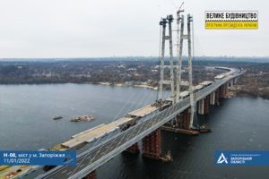
New Zaporizhzhia Dniper Bridge
Bridge in Zaporizhzhia, Ukraine
Distance: Approx. 5894 meters
Latitude and longitude: 47.8426,35.0855
The New Zaporizhzhia Dniper Bridge is a controlled-access highway bridge currently under construction in Zaporizhzhia, Ukraine. Construction of the bridge began in August 2004 with the first span of the bridge opened for public vehicular use in January 2022 after several years of delays. The bridge was opened in a public ceremony on 22 January 2022, by President Volodymyr Zelensky.

Voznesenivskyi District
City district of Zaporizhzhia, Ukraine
Distance: Approx. 2344 meters
Latitude and longitude: 47.81638889,35.05472222
Voznesenivskyi District (Ukrainian: Вознесенівський район) is an administrative-territorial unit within the city of Zaporizhzhia, Ukraine named after the historical village of Voznesenky. The economic and symbolic center of the city and the Zaporizhzhia metropolitan area, it is Zaporizhzhia's oldest district and home to many of region's cultural, financial, educational and historical landmarks including Zaporizhzhia Regional Administration, Krytyy Market and Festival Square. The district was formed on January 21, 1939, as Ordzhonikidzevskyi District in honor of Sergo Ordzhonikidze.
Khortytsia, Zaporizhzhia Oblast
Village in Zaporizhzhia Oblast, Ukraine
Distance: Approx. 6489 meters
Latitude and longitude: 47.84944444,35.01527778
Khortytsia (Ukrainian: Хортиця) is a village (a selo) in the Zaporizhzhia Raion (district) of Zaporizhzhia Oblast in southern Ukraine.

Staryi Dnipro
Anabranch of the Dniper river in Ukraine
Distance: Approx. 7736 meters
Latitude and longitude: 47.86388889,35.06888889
The Staryi Dnipro (Ukrainian: Старий Дніпро, lit. 'Old Dnieper') is a anabranch of the Dnieper near Zaporizhzhia that is separated by the island of Khortytsia from the mainstream.
Weather in this IP's area
overcast clouds
6 Celsius
2 Celsius
6 Celsius
6 Celsius
1025 hPa
83 %
1025 hPa
1015 hPa
10000 meters
5.55 m/s
8.33 m/s
19 degree
100 %
07:04:45
17:44:23