Country:
Region:
City:
Latitude and Longitude:
Time Zone:
Postal Code:
IP information under different IP Channel
ip-api
Country
Region
City
ASN
Time Zone
ISP
Blacklist
Proxy
Latitude
Longitude
Postal
Route
Luminati
Country
ASN
Time Zone
Europe/Brussels
ISP
SD Worx Sociaal Secretariaat VZW
Latitude
Longitude
Postal
IPinfo
Country
Region
City
ASN
Time Zone
ISP
Blacklist
Proxy
Latitude
Longitude
Postal
Route
db-ip
Country
Region
City
ASN
Time Zone
ISP
Blacklist
Proxy
Latitude
Longitude
Postal
Route
ipdata
Country
Region
City
ASN
Time Zone
ISP
Blacklist
Proxy
Latitude
Longitude
Postal
Route
Popular places and events near this IP address
Het Steen
Fortress in Antwerp, Belgium
Distance: Approx. 646 meters
Latitude and longitude: 51.2227,4.3974
Het Steen is a medieval fortress in the old city centre of Antwerp, Belgium, one of Europe's biggest ports. The surviving structure was built between 1200 and 1225 as a gateway to a larger castle of the Dukes of Brabant which was demolished in the 19th century. As the first stone fortification (city wall) of Antwerp, Het Steen is Antwerp's oldest building and used to be part of its oldest urban centre.

University of Antwerp
University in Antwerp, Belgium
Distance: Approx. 663 meters
Latitude and longitude: 51.22277778,4.41
The University of Antwerp (Dutch: Universiteit Antwerpen) is a major Belgian university located in the city of Antwerp. The official abbreviation is UAntwerp. The University of Antwerp has about 20,000 students, which makes it the third-largest university in Flanders.
Royal Academy of Fine Arts (Antwerp)
Art academy in Antwerp
Distance: Approx. 477 meters
Latitude and longitude: 51.2234,4.4069
The Royal Academy of Fine Arts Antwerp (Dutch: Koninklijke Academie voor Schone Kunsten van Antwerpen) is an art academy located in Antwerp, Belgium. It is one of the oldest of its kind in Europe. It was founded in 1663 by David Teniers the Younger, painter to the Archduke Leopold Wilhelm and Don Juan of Austria.

Letterenhuis
Distance: Approx. 486 meters
Latitude and longitude: 51.222809,4.404728
The Letterenhuis ("House of Literature") is a Belgian non-profit organization located in Antwerp. The Letterenhuis collects and archives information of Flemish artists, musicians, and writers, as well as portraits concerning Flemish culture as from 1750. The Letterenhuis fulfills two tasks: on the one hand it is an archiving and documentation centre and on the other hand it is a museum.
Institute of Development Policy and Management
Distance: Approx. 612 meters
Latitude and longitude: 51.22349,4.41007
The Institute of Development Policy (IOB) is an independent institute of the University of Antwerp in Antwerp, Belgium. The institute is involved in academic teaching, scientific research and service to the community in the area of economic, political and social aspects of development policy and management. The institute offers three master programs in Development Evaluation and Management, Governance and Development, and Globalisation and Development.

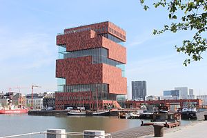
Museum aan de Stroom
Museum in Antwerp, Belgium
Distance: Approx. 231 meters
Latitude and longitude: 51.229,4.4048
The Museum aan de Stroom (MAS; Dutch for: Museum by the Stream) is a museum located along the river Scheldt in the Eilandje district of Antwerp, Belgium. It opened in May 2011 and is the largest museum in Antwerp.

St. Charles Borromeo Church, Antwerp
Church in Antwerp, Belgium
Distance: Approx. 677 meters
Latitude and longitude: 51.22105556,4.40447222
St. Charles Borromeo Church (Dutch: Sint-Carolus Borromeuskerk) is a Roman Catholic church in central Antwerp, Belgium, located on the Hendrik Conscienceplein. It was built in 1615–1621 as the Jesuit church of Antwerp, which was closed in 1773.

Vleeshuis
Museum and former guildhall in Antwerp, Belgium
Distance: Approx. 572 meters
Latitude and longitude: 51.2227,4.3992
The Vleeshuis (Butcher's Hall, or literally Meat House) in Antwerp, Belgium, is a former guildhall. It is now a museum located between the Drie Hespenstraat, the Repenstraat and the Vleeshouwersstraat. The slope where the Drie Hespenstraat meets the Burchtgracht used to be known as the Bloedberg or Blood Mountain.

St. Paul's Church, Antwerp
Distance: Approx. 383 meters
Latitude and longitude: 51.22391667,4.40136111
St. Paul's Church (Dutch: Sint-Pauluskerk) is a Roman Catholic church located at the Veemarkt in Antwerp, Belgium. Its exterior is mainly Gothic with a Baroque tower while the interior is characterised by its rich Baroque decoration.
Café d'Anvers (Club)
Nightclub in Antwerp, Belgium
Distance: Approx. 107 meters
Latitude and longitude: 51.2262,4.404
Café d'Anvers was a nightclub in Antwerp, Belgium. In 2011 it was voted number 38 in DJ Magazine's "Top 100 Clubs in the World" poll. In April 2019, the club assistant-manager announced the immediate closing of the club, before its 30th birthday.

Snijders&Rockox House
Museum in Antwerp, Belgium
Distance: Approx. 629 meters
Latitude and longitude: 51.2217,4.4061
The Snijders&Rockox House (Dutch: Snijders&Rockoxhuis) is a museum in Antwerp, Belgium. It is located in two neighbouring townhouses formerly owned by the artist Frans Snyders (1579–1657) and the mayor Nicolaas Rockox (1560–1640). It is owned by KBC Bank and showcases a collection of 16th and 17th century Flemish art.

Artesis Plantijn University College of Antwerp
Distance: Approx. 652 meters
Latitude and longitude: 51.22166667,4.40694444
AP University of Applied Sciences and Arts Antwerp , founded in 2012, is a non-profit public higher education institution located in the city of Antwerp and created as a merger between Artesis Hogeschool Antwerpen and Plantijn Hogeschool [1] [2]. In the 2023–2024 academic year, the University of Applied Sciences and Arts started with 26 bachelor programs, 17 associate programs, 9 master programs and 16.000 students. AP Hogeschool is a member of AUHA, the Antwerp University Association.
Weather in this IP's area
drizzle
8 Celsius
8 Celsius
8 Celsius
9 Celsius
1027 hPa
98 %
1027 hPa
1026 hPa
2300 meters
1.03 m/s
220 degree
100 %
07:44:24
17:07:40

