91.214.85.117 - IP Lookup: Free IP Address Lookup, Postal Code Lookup, IP Location Lookup, IP ASN, Public IP
Country:
Region:
City:
Location:
Time Zone:
Postal Code:
ISP:
ASN:
language:
User-Agent:
Proxy IP:
Blacklist:
IP information under different IP Channel
ip-api
Country
Region
City
ASN
Time Zone
ISP
Blacklist
Proxy
Latitude
Longitude
Postal
Route
db-ip
Country
Region
City
ASN
Time Zone
ISP
Blacklist
Proxy
Latitude
Longitude
Postal
Route
IPinfo
Country
Region
City
ASN
Time Zone
ISP
Blacklist
Proxy
Latitude
Longitude
Postal
Route
IP2Location
91.214.85.117Country
Region
kyivska oblast
City
brovary
Time Zone
Europe/Kiev
ISP
Language
User-Agent
Latitude
Longitude
Postal
ipdata
Country
Region
City
ASN
Time Zone
ISP
Blacklist
Proxy
Latitude
Longitude
Postal
Route
Popular places and events near this IP address

Brovary
City in Kyiv Oblast, Ukraine
Distance: Approx. 1415 meters
Latitude and longitude: 50.51111111,30.79
Brovary (Ukrainian: Бровари, IPA: [browɐˈrɪ] ; Yiddish: בראָוואַר, romanized: Brovar) is a city in Kyiv Oblast, northern Ukraine, situated to the east of the capital Kyiv and part of the Kyiv metropolitan area. It serves as the administrative centre of Brovary Raion. Brovary hosts the administration of Brovary urban hromada, one of the hromadas of Ukraine.
Bykivnia graves
Memorial and mass grave for Soviet dissidents in Kyiv, Ukraine
Distance: Approx. 9481 meters
Latitude and longitude: 50.46666667,30.7
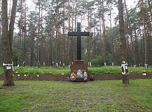
The Bykivnia graves (Ukrainian: Биківнянські могили) are a National Historic Memorial next to the former village of Bykivnia (Ukrainian: Биківня, Polish: Bykownia) within Kyiv woodland, Bykivnia Forest. During the Stalinist period in the Soviet Union, it was one of the unmarked mass grave sites where the NKVD, the Soviet secret police, disposed of thousands of executed "enemies of the Soviet state". Bykivnia as a residential place still exists as a locality with the same Bykivnia Forest.

Desnianskyi District, Kyiv
Urban district in Kyiv in Ukraine
Distance: Approx. 7376 meters
Latitude and longitude: 50.53,30.70416667
Desnianskyi District is an administrative raion (district or borough) of the city of Kyiv, the capital of Ukraine. It is located in the north-eastern part of the city on the Left Bank of the Dnieper River and is the most populous district of Kyiv. It is also the second largest district, with the total area of ca.

Brovary railway station
Distance: Approx. 612 meters
Latitude and longitude: 50.51438889,30.81308333
Brovary (Ukrainian: Бровари) is a railway station located in Brovary, Ukraine.

Kalynivka, Brovary Raion, Kyiv Oblast
Rural locality in Kyiv Oblast, Ukraine
Distance: Approx. 4684 meters
Latitude and longitude: 50.55916667,30.82111111
Kalynivka (Ukrainian: Калинівка) is a rural settlement in Brovary Raion (district) of Kyiv Oblast (province) in northern Ukraine. It hosts the administration of Kalynivka settlement hromada, one of the hromadas of Ukraine. Its population is 6,178 as of the 2001 Ukrainian Census.
Kniazhychi
Distance: Approx. 6402 meters
Latitude and longitude: 50.4625,30.78361111
Kniazhychi (Ukrainian: Княжичі; Russian: Княжичи; Polish: Kniażyci) is a village in the Kyiv Oblast (province) of northern Ukraine. The village has a population of 5202. The total area of land within the administrative boundaries of Kniazhychi village council is 3669.3 hectares.

Bykivnia Forest
Urban forest stretching from the eastern side of Kyiv from the National Park of Zalissia
Distance: Approx. 7886 meters
Latitude and longitude: 50.4738,30.7198
Bykivnia Forest (Ukrainian: Биківнянський ліс) is an urban forest consisting mostly of pine trees (90%), and stretching on the eastern side of Kyiv from the National Park Zalissia in southern direction towards Bortnychi, creating a green belt. It is primarily associated with the Memorial Park Bykivnia Graves, which is located within it. On 19th century maps, the western outskirts of Bykivnia Forest show that it once reached the Dnieper.

Kyiv Theological Seminary of the Three Holy Hierarchs
Seminary school in Kniazhychi, Ukraine
Distance: Approx. 8014 meters
Latitude and longitude: 50.45788889,30.74466667
Kyiv Theological Seminary of the Three Holy Hierarchs is seminary of the Ukrainian Greek Catholic Church near Kyiv, Ukraine, which is jointly administered by the Ukrainian Catholic Archeparchy of Kyiv and the missionary exarchates of Lutsk, Kharkiv, Odesa, and Donetsk. When the Ukrainian Greek Catholic Church was banned in the Russian Empire in the 19th century, the Church existed only in Western Ukraine and the diaspora. After Ukraine declared independence from the Soviet Union in 1991, the UGCC began to return to Central and Eastern Ukraine.
Battle of Brovary
Battle in the 2022 invasion of Ukraine
Distance: Approx. 1382 meters
Latitude and longitude: 50.51138889,30.79027778
During the Russian invasion of Ukraine, a military engagement took place at Brovary, an eastern suburb of Kyiv, the capital city of Ukraine. Russian forces advanced west from southern Chernihiv Oblast and were engaged by Ukrainian forces. Russian forces withdrew from the area by 1-2 April 2022.

2023 Brovary helicopter crash
Transport disaster in Kyiv Oblast, Ukraine
Distance: Approx. 464 meters
Latitude and longitude: 50.52027778,30.80111111
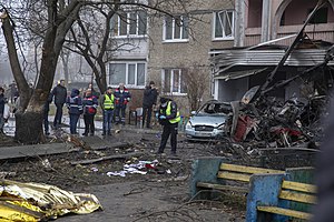
On 18 January 2023, a Ukrainian Eurocopter EC225 Super Puma carrying ten people, including Ukrainian Minister of Internal Affairs Denys Monastyrsky, his deputy Yevhen Yenin, and State Secretary Yurii Lubkovych, crashed into a kindergarten in Brovary, a suburb of Kyiv, Ukraine. The crash killed fourteen people, including Monastyrsky, Yenin, and Lubkovych. Four of the victims were killed on the ground, including one child.
Weather in this IP's area
overcast clouds
4 Celsius
3 Celsius
4 Celsius
4 Celsius
1024 hPa
82 %
1024 hPa
1009 hPa
10000 meters
1.99 m/s
4.56 m/s
192 degree
100 %
